Hiking the Eagle Creek Trail
If you have seen one photograph of a Pacific Northwest waterfall, there is a good chance it was Punchbowl Falls. The 33-foot plunge sits two miles up the Eagle Creek Trail, and for most of the last century it was the easiest dramatic waterfall in Oregon to walk to. The trail itself, hand-blasted into basalt cliffs above an emerald creek, is more remarkable than the destination.
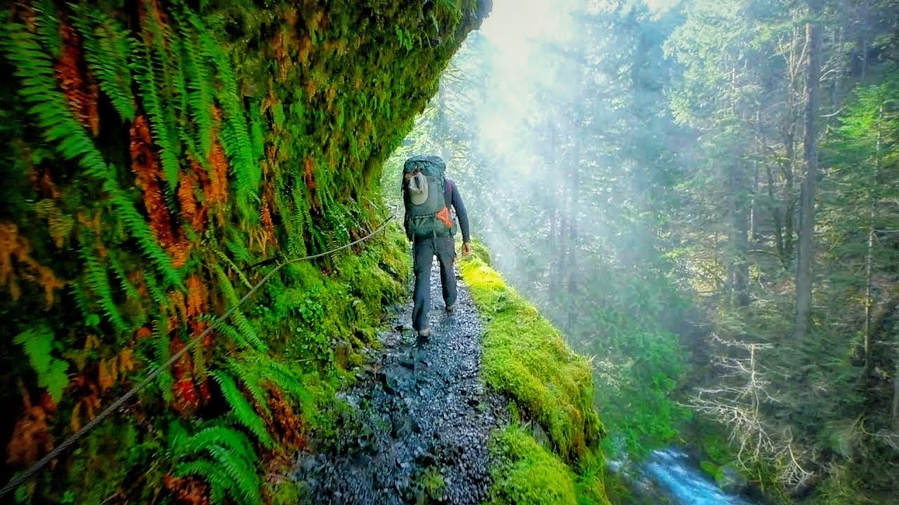
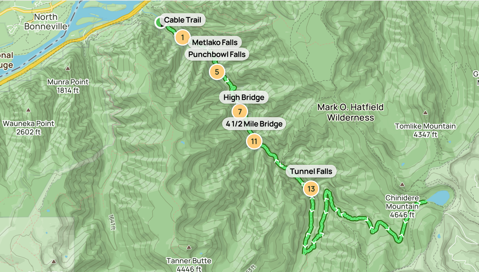
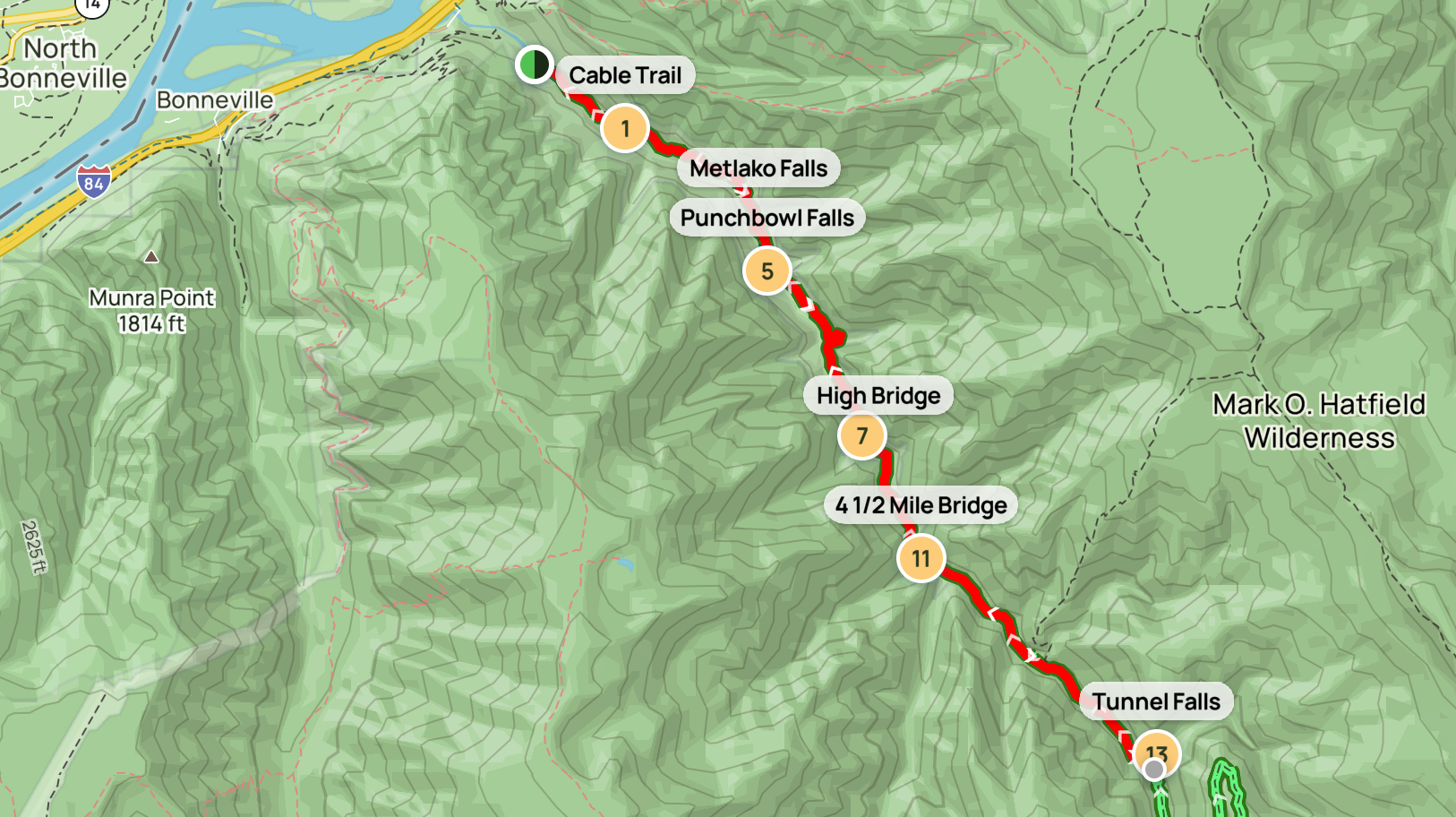
Eagle Creek Trail #440 is the 12.9-mile route past eight named waterfalls, including the iconic Punchbowl and the 175-foot Tunnel Falls, where the trail passes literally behind the cascade through a hand-cut tunnel. Forest Service crews blasted the original grade into the cliffs between 1910 and 1916, fitting cable handrails along sections where the path narrows to two feet wide above lethal drops.
The bigger story now is what the trail has survived, and what it has not survived yet. We are tracking three converging realities on this page: when (and whether) the trail reopens, what the route looks like when it does, and where to redirect a Gorge waterfall trip in the meantime. For broader context, see our Columbia River Gorge hikes hub and the Oregon waterfalls map.

Eagle Creek Trail #440 is closed indefinitely
A USFS Forest Order took effect January 21, 2026 and remains in force through October 31, 2026 (or until rescinded), prohibiting entry under 36 CFR 261.55(a). The closure was issued after December 2025 atmospheric-river storms triggered multiple landslides and complete trail-tread washouts across the cliffside route. Locked gates and signage are in place at the trailhead.
Violations carry fines up to $5,000 for individuals and $10,000 for organizations, plus potential imprisonment. The Pacific Crest Trail Association is coordinating volunteer work parties for restoration. Check the official USFS alert page for current status.
The closure, in detail
The simple version: Eagle Creek Trail #440 is closed and will not reopen in 2026. The longer version, which matters because hikers keep showing up at the locked gate, is worth reading before you make a drive out from Portland.
What happened
In mid-December 2025, an atmospheric-river system parked over the western Cascades for nearly a week, dropping a season’s worth of rain in five days. The Eagle Creek drainage, already destabilized by the 2017 fire and a 2018 landslide, took the brunt of it. By the time the rain stopped, Forest Service ground assessments documented multiple landslides, complete trail-tread washouts on at least three cliffside sections, and severe damage to bridges and stair structures higher in the canyon.
The Forest Order
On January 21, 2026, the Columbia River Gorge National Scenic Area issued a Forest Order under 36 CFR 261.55(a) closing the trail to all foot traffic. The same order also closed the nearby Wahclella Falls Trail #436, which suffered comparable damage. The order is signed for the period through October 31, 2026, but USFS communications make clear that the closure will be extended if repairs are not complete.
We have seen multiple social-media posts of hikers reaching Punchbowl in 2026 despite the closure. This is not a soft closure. Fines reach $5,000 per individual under 36 CFR 261.55, and the trail genuinely has missing tread above lethal drops. Wait for the reopening.
What reopening will look like
Eagle Creek does not reopen all at once. Based on how the 2017 post-fire reopening played out, expect a staged process: the Forest Service first reopens the lower trail to roughly the High Bridge area, with the upper trail (Tunnel Falls and beyond) following months or years later. The 2017 fire took until summer 2021 to result in a full reopening. The 2025 storm damage is reportedly worse in some sections than the fire damage was.
The Pacific Crest Trail Association has begun coordinating volunteer trail-restoration work parties along the lower section. If you want to be part of bringing this trail back, their volunteer program is the route in.
The 2017 fire scorched the entire drainage. The 2018 cliff collapse reshaped Lower Punchbowl. The 2025 storms have pushed the trail past its limit. Hike it when you can. Will, Oregon Tails
Vitals and route options
Eagle Creek is rarely hiked end-to-end. Most visitors pick a turnaround point based on their fitness, time, and tolerance for cliff exposure. Here is the standard menu.
| Turnaround | Round trip | Elev. gain | Time | Difficulty |
|---|---|---|---|---|
| Metlako Falls overlook | 3.0 mi | 400 ft | 1.5–2 hr | Easy |
| Punchbowl Falls (lower) | 3.8 mi | 500 ft | 2–3 hr | Moderate |
| High Bridge | 6.6 mi | 800 ft | 4–5 hr | Moderate |
| Tunnel Falls | 12.0 mi | 1,200 ft | 6–8 hr | Difficult (exposure) |
| Wahtum Lake (full trail) | 25.8 mi | ~3,800 ft | 2–3 days | Backpacking |
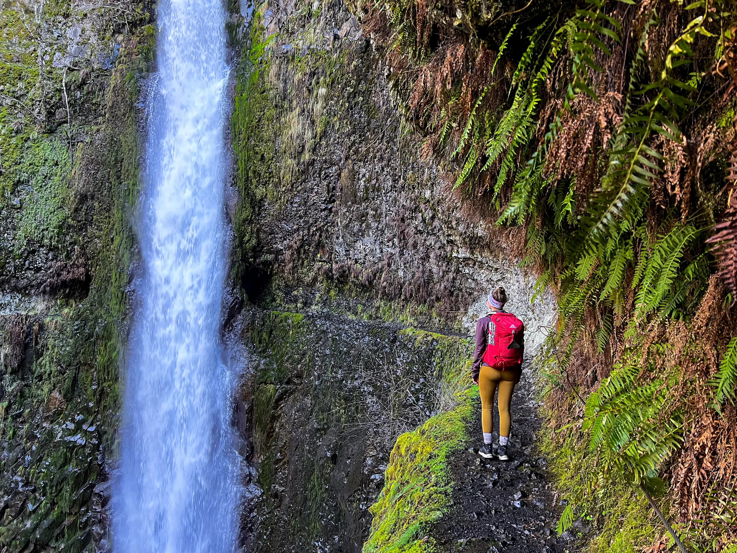
The “moderate” rating is misleading on flat-ground terms. Elevation gain is gentle by Oregon standards, with no sustained climb steeper than 10 percent until the Tunnel Falls switchbacks. What makes Eagle Creek difficult is exposure: long sections of trail run two to three feet wide along cliffs with thirty- to eighty-foot drops to the creek. Cable handrails are bolted into the rock at the worst sections, but they are no substitute for sure footing.
Punchbowl Falls at 3.8 miles round trip. You see Metlako on the way, get the iconic Punchbowl photo, and turn back before the trail’s most exposed sections. Tunnel Falls is the more dramatic destination, but the cable-handrail traverse beyond Punchbowl rewards experience.
Mile by mile
This is what you experience when the trail is open, working from the Eagle Creek Trailhead at the parking area off Exit 41 of Interstate 84.
Mile 0 to 1: The cliff start
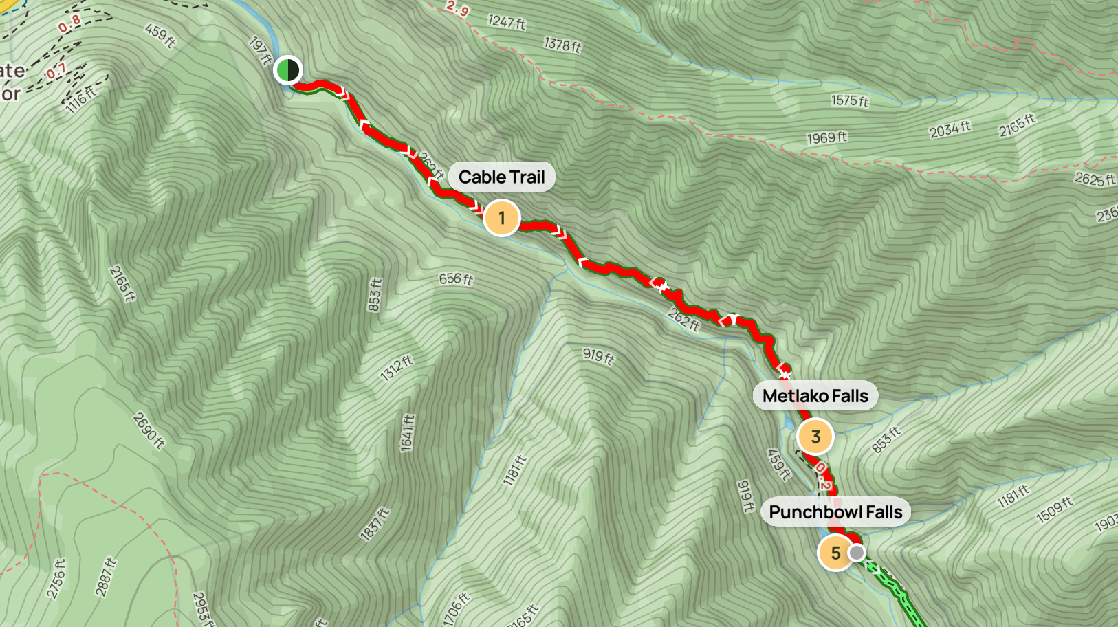
The trail leaves the parking area gently, climbing through second-growth Douglas fir along a wide path. Within about half a mile, the route turns abruptly into the canyon and the cliffs begin. This is where the historic blasted-grade work becomes obvious: the trail tread is literally cut into the rock face, with cable handrails on the outside edge. Drops below the trail run thirty to fifty feet to the creek. This first stretch is also where most of the December 2025 damage occurred.
Mile 1.5: Metlako Falls overlook
A short spur leads to a wooden viewing platform where you can see Metlako Falls, a 100-foot plunge into a deep amphitheater. The original platform collapsed in 2016, and the view from the rebuilt overlook is partially obscured. Many guidebooks still describe the older, dramatic view; the current view is good but not great.
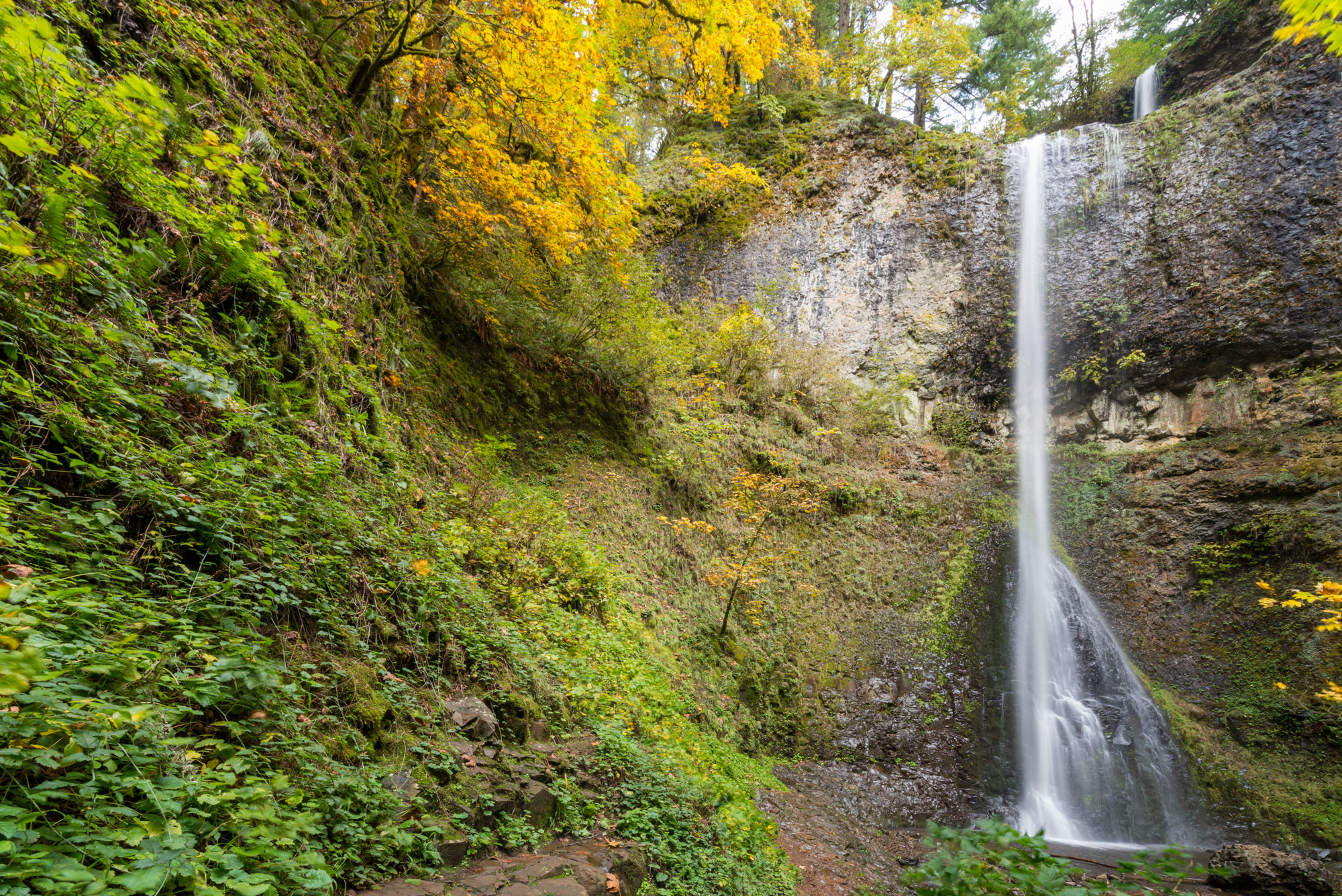
Mile 1.9: Punchbowl Falls (Lower viewpoint)
A clearly marked side trail descends about 200 feet to the lower viewpoint, where the creek widens into a gravel bar opposite the falls. This is the photograph you have seen: a 33-foot plunge into a circular pool, walls of basalt rising on three sides. The pool itself was more than ten feet deeper before the 2018 cliff collapse partially filled it with debris.
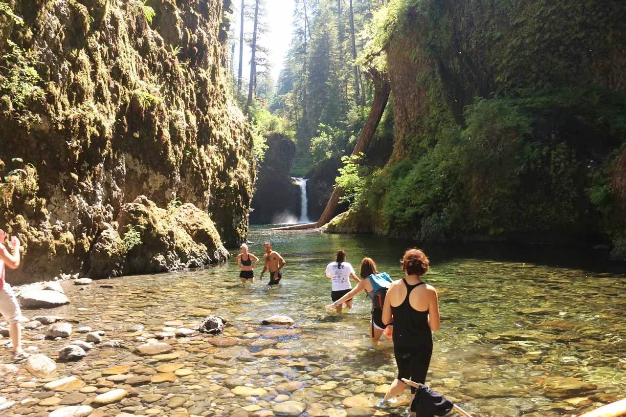
Don’t jump at Punchbowl
Punchbowl has a long history of fatalities from cliff jumping. Diving from the rim into the pool is illegal, and the water depth and submerged debris make it genuinely lethal. The lower viewpoint is the destination. The pool below is for looking at.
Mile 3.3: High Bridge
Beyond Punchbowl, the trail traverses some of its most exposed cable-handrail sections, then crosses Eagle Creek on High Bridge, a 100-foot wooden span 80 feet above the water. This is a strong alternative turnaround point if you want a longer hike without committing to the upper trail. Loowit Falls is visible just downstream from the bridge.
Mile 4.5 to 5.5: The middle waterfalls
The trail above High Bridge eases somewhat, with fewer cliff sections but longer climbs. You pass Skoonichuk Falls (mile 4.5), then climb through a series of switchbacks past Grand Union Falls and several unnamed cascades. Backcountry campsites along this stretch are the standard first-night stop for Wahtum Lake backpackers.
Mile 6.0: Tunnel Falls
The upper Eagle Creek Trail’s signature feature. Tunnel Falls is a 175-foot single-drop waterfall, and the trail passes literally behind the falling water through a tunnel that early Forest Service crews hand-blasted into the cliff. The tunnel is roughly 12 feet long and dripping wet; the rock is slippery; the floor angles outward toward a railing-protected drop. There is nothing else like it in Oregon.
Mile 6.2: Twister Falls
Just beyond Tunnel Falls, Twister Falls drops in a corkscrew shape that gives the falls its name. Most hikers visit Twister as a brief detour and then turn around at this point, making the full out-and-back 12.4 miles.
Mile 12.9: Wahtum Lake
The full trail eventually climbs out of the Eagle Creek drainage and connects to the Pacific Crest Trail near Wahtum Lake, a glacial cirque at 3,732 feet. The Eagle Creek route is the famous “PCT alternate,” historically used by thru-hikers who wanted to substitute the waterfall scenery for the standard PCT route over Indian Mountain.
Built, burned, collapsed, rebuilt
Eagle Creek’s story is the story of how trails get destroyed, reopened, and destroyed again. The current closure is the third major closure in nine years, and the pattern is worth understanding.
-
1910–1916
Forest Service crews hand-blast the original route into the cliffs as part of the Columbia River Highway construction era. Cable handrails are installed at the worst sections. The Tunnel Falls tunnel is cut by hand.
-
1930s
Civilian Conservation Corps crews stabilize and improve the trail, building masonry retaining walls, the wooden bridges, and the campsites at Tenas, Blue Grouse, and Wahtum Lake. Many of the structures still in use date from this period.
-
September 2017
A 15-year-old throws a firework into Eagle Creek canyon during a windy late-summer day. The Eagle Creek Fire burns 48,861 acres across the Columbia River Gorge over the next three months, including the entire Eagle Creek drainage. The trail closes and remains closed for years.
-
January 2018
A massive cliff collapse at Punchbowl Falls drops thousands of cubic yards of rock into the lower pool, partially filling it and reshaping the iconic viewpoint. The destabilization is attributed to fire-killed root systems no longer holding the cliffs together.
-
2018–2021
Phased reopenings. The lower trail to High Bridge reopens in summer 2018 with restrictions; full reopening to Tunnel Falls and Wahtum Lake follows in summer 2021 after extensive bridge and tread repairs by USFS and PCTA volunteers.
-
December 2025
A multi-day atmospheric-river storm dumps unprecedented rainfall on the still-fragile drainage. Multiple landslides, complete trail-tread washouts, and bridge damage close the trail again. The Forest Order takes effect January 21, 2026.
The geology behind the canyon
The cliffs that make Eagle Creek dramatic are also why it keeps falling apart. The canyon walls are stacked layers of Columbia River basalt: massive lava flows that covered roughly 50,000 square miles of Eastern Washington, Eastern Oregon, and Idaho between 17 and 10 million years ago. The flows reached depths of up to a mile in places and rerouted the ancient Columbia River north to its current channel. What you see along the trail are the cooled edges of those flows, exposed by millennia of water erosion.
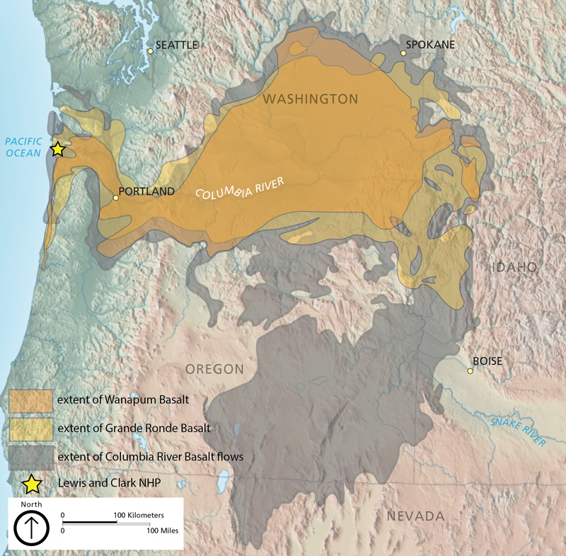
This stacked structure is what gives Eagle Creek its character: water cuts down through softer interflow zones while the harder flow centers form the cliffs. The same structure is also what makes the trail unstable. When fire kills the root systems anchoring the soil between flow units, and atmospheric rivers saturate everything, the bands separate and slide. The 2018 Punchbowl collapse and the 2025 storm damage are both this geology in action.
Permits, fees & parking
When the trail is open, Eagle Creek has one of the simpler permit setups in the Gorge.
Day-use pass
A Northwest Forest Pass ($5/day or $30/year) or America the Beautiful interagency pass is required at the Eagle Creek Trailhead. Passes are sold at the trailhead kiosk (cash or check) or online through the Forest Service. There is no quota or timed-entry permit for day hikers, even on the busiest summer weekends.
Wilderness permit
The upper trail enters the Mark O. Hatfield Wilderness. Day hikers do not need a separate permit. Backpackers staying overnight in the wilderness should self-register at the trailhead board and follow the standard wilderness regulations: groups of 12 or fewer, no fires above 4,500 feet, pack out all waste.
Parking
The trailhead parking lot off Exit 41 holds about 50 cars. On summer weekends, it fills before 8 a.m. and overflow parking lines the access road for half a mile. There is no shuttle service to Eagle Creek (unlike Multnomah Falls). Plan to arrive early or accept a long walk from your car. Vehicle break-ins have been a recurring problem at this trailhead. Take valuables with you.
From Portland, the trailhead is about 41 miles east on I-84, roughly a 44-minute drive in light traffic. Take Exit 41 (Eagle Creek Recreation Area), turn right at the bottom of the off-ramp, and follow the access road to the trailhead lot.
If the main lot is full, drive 0.4 miles east to the Eagle Creek Overlook viewpoint, which has a smaller lot and a 0.4-mile spur trail that connects to the main route. It rarely fills.
Season & conditions
Eagle Creek is a low-elevation trail (the trailhead sits at 145 feet, Punchbowl at about 400 feet) and is technically hikeable year-round, but conditions vary dramatically by season.
Every cascade runs at maximum volume, and canyon walls drip with seeps that disappear by July. Trade-offs: mud, slick rock, and high creek levels. Best season for waterfall photography by a wide margin.
Trailhead parking fills by 8 a.m. on weekends. Water levels drop and cliff-edge sections become safer. Smoke from regional wildfires can affect visibility late July through September.
Bigleaf maple and vine maple turn yellow and red along the canyon. Crowds drop to a fraction of summer numbers. October weekends are arguably the best time on Eagle Creek if you can hit a dry window.
Low-elevation enough to stay snow-free, but ice forms on the spray-coated rock. Microspikes essential past mile 1. The cable-handrail sections become genuinely dangerous in freezing temperatures.
Safety on Eagle Creek
Eagle Creek has one of the highest fatality counts of any trail in Oregon. Most are preventable. The four hazards worth understanding:
Cliff exposure
The cable-handrail sections look more dramatic than they are dangerous, but they account for the majority of falls. The rock is glacially polished, the cables are at adult waist height (not knee-height for kids), and there is no margin for a slip. Keep children leashed by hand or harnessed, never let them run, and step aside for uphill traffic at narrow sections.
Cliff diving
Punchbowl’s pool depth varies year to year and contains submerged debris from the 2018 collapse. People still jump despite signage and despite a documented fatality history. The water is opaque enough that you cannot see what you are landing on. Do not jump.
Dogs
Eagle Creek is technically dog-permitted on leash, but the cable-handrail sections are not safe for dogs. Several dogs have died here; the cable spacing does not stop a dog from going over the edge. Limit dogs to the first mile, and use a chest harness rather than a collar leash.
Trail damage and runoff
Even when the trail is officially open, sections may be damaged from recent storms. Watch for trail tread that has slumped toward the edge, missing cable segments, and creek-crossing bridges that may have shifted. If something looks wrong, turn around. The Forest Service updates conditions weekly during the active season.
What to pack
Eagle Creek is a low-elevation, tree-shaded trail with reliable water access (the creek runs alongside the trail for most of the route). Your pack list reflects that.
- Sturdy hiking footwear. The wet rock sections demand grip. Trail runners with aggressive lugs work for short hikes; full hiking boots are better for the cable-handrail traverses. See our guide to choosing hiking boots.
- Trekking poles. Worth the weight for the long downhills back from Tunnel Falls. They take pressure off knees and provide a third point of contact on slick rock. See are trekking poles worth it.
- 2 liters of water minimum. The creek is right there, but it requires filtration. Bring a filter or chemical treatment; do not drink straight from Eagle Creek.
- Rain shell. Even on dry-forecast days, the spray near Tunnel Falls and the seasonal seeps along the cliffs will soak you.
- Layers. The canyon stays cool even in summer (shaded, often 15°F below the surrounding open areas).
- The Ten Essentials. Cell coverage is spotty in the canyon. Carry a paper map, headlamp, first aid, and emergency shelter for any hike beyond Punchbowl.
For the multi-day Wahtum Lake trip, add a water filter rated for North American backcountry, a bear-resistant food storage system (bear canisters are recommended in Hatfield Wilderness), and a stove. Campfires are restricted above 4,500 feet and during summer fire bans.
Gear that handles Gorge trails
Eagle Creek punishes underbuilt gear. Wet rock, cable-handrail sections, and long damp days call for traction, support, and weatherproofing. Independent reviews of what we’d actually pack for this trail.


Where to hike instead
While Eagle Creek is closed, four alternatives capture different parts of what makes it special. None is a perfect substitute, but together they cover the bases.
For waterfall density: Trail of Ten Falls (Silver Falls State Park)
The closest thing Oregon has to an Eagle Creek replacement. Ten waterfalls in 7.2 miles, four of which the trail passes behind, including the 177-foot South Falls. Fully open, well-maintained, and family-friendly without Eagle Creek’s cliff exposure. Read our Silver Falls trail guide.
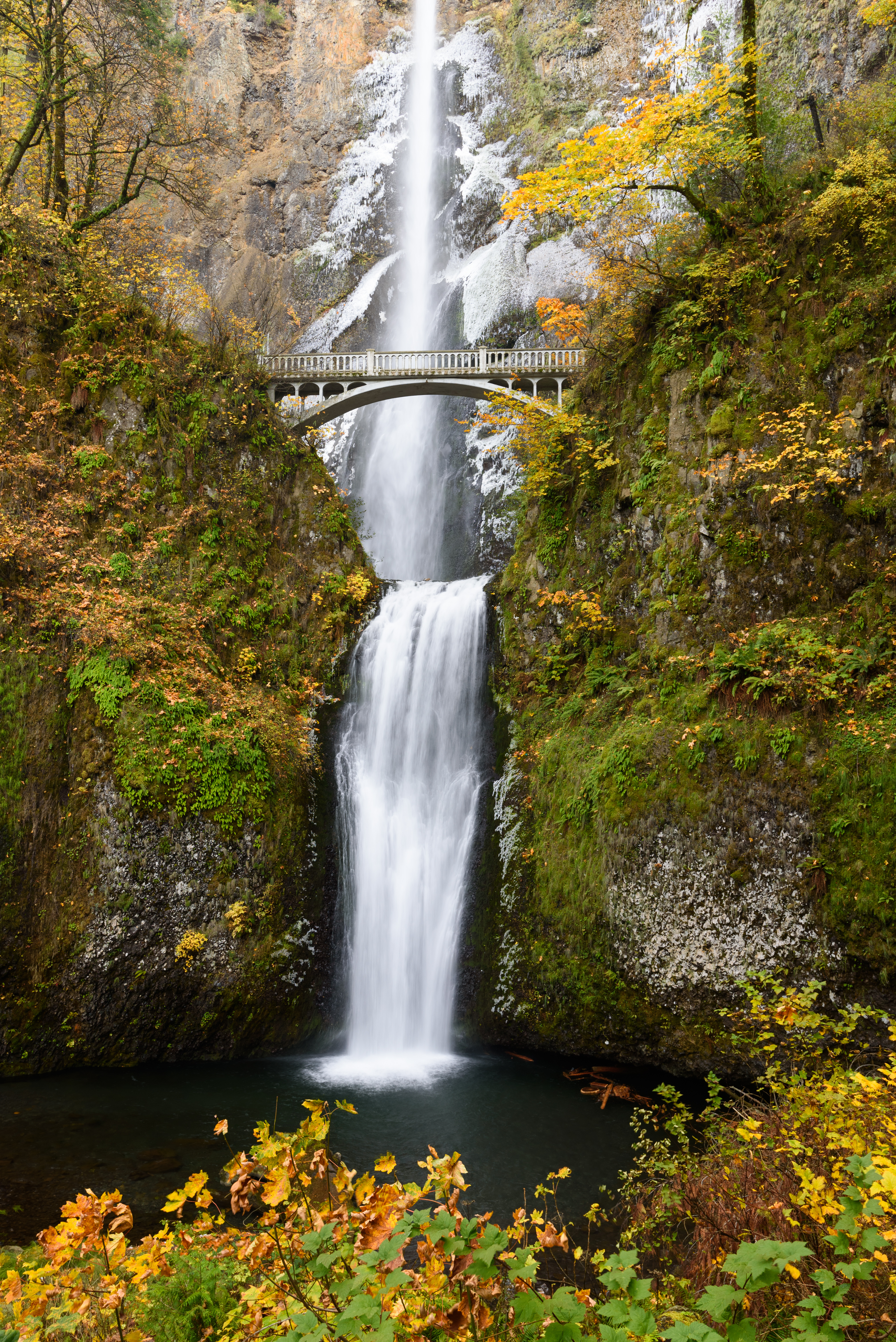
For a short Gorge alternative: Latourell Falls
A 2.4-mile loop in the western Gorge featuring the 224-foot Latourell Falls, easily one of the prettiest single-drop waterfalls in Oregon. Easy grade, no cable handrails, family-suitable. Latourell Falls guide.
For dramatic cliff exposure: Oneonta Trail to Triple Falls
3.6 miles round trip, moderate, with a similar cliff-trail feel to Eagle Creek but more open. Triple Falls is a 135-foot triple-channel cascade that photographs beautifully. The Lower Oneonta Falls log-jam route remains closed indefinitely after the 2017 fire, but the upper trail is open.
For a backpacking trip: PCT to Wahtum Lake (north approach)
You can still reach Wahtum Lake by the standard PCT route from the south or from Wahtum Lake Trailhead itself, just not through Eagle Creek. The connector to the PCT and beyond is the long-distance route Eagle Creek backpackers will pivot to.
For a full ranking, see our roundup of the best waterfall hikes in Oregon.
Eagle Creek, answered
No. Eagle Creek Trail #440 is closed under a USFS Forest Order effective January 21, 2026 through October 31, 2026 (or until rescinded). The closure was issued after December 2025 atmospheric-river storms triggered multiple landslides that destroyed sections of the historic cliffside route. Locked gates and signage are in place at the trailhead. Violations carry fines up to $5,000 for individuals and $10,000 for organizations under 36 CFR 261.55(a).
The full trail is 12.9 miles one way to Wahtum Lake, but most hikers turn around earlier. Common turnaround points: Punchbowl Falls (3.8 miles round trip, 2 to 3 hours), High Bridge (6.6 miles round trip, 4 to 5 hours), and Tunnel Falls (12 miles round trip, 6 to 8 hours). The trail is rated moderate to difficult primarily because of cliffside exposure rather than elevation gain.
Swimming at the lower viewpoint pool has historically been popular, but cliff diving from the canyon walls is illegal and has caused multiple fatalities at Punchbowl over the years. After the 2017 fire and 2018 cliff collapse, the wade-up route to the upper falls became hazardous due to logjams and debris. When the trail reopens, expect signage prohibiting jumping and use extreme caution if entering the water.
Dogs are technically permitted on leash, but Eagle Creek is one of the worst dog hikes in Oregon. The narrow cliffside sections with cable handrails and exposed drops are genuinely dangerous for dogs, who don’t understand edge awareness the way humans do. Several dogs have died on this trail. If you must bring a dog when the trail reopens, turn around at the first cliff section, well before Punchbowl.
When open, a Northwest Forest Pass ($5 day or $30 annual) or America the Beautiful interagency pass is required at the trailhead. No quota or timed-entry permit is needed for day hiking. Backpackers heading deeper into Hatfield Wilderness should check current wilderness permit requirements with the Columbia River Gorge National Scenic Area before their trip.
Tunnel Falls is the iconic destination of the upper Eagle Creek Trail: a 175-foot cascade where the trail passes literally behind the falling water through a hand-cut tunnel blasted into the cliff. It sits roughly 6 miles from the trailhead, making it a 12-mile round trip with about 1,200 feet of elevation gain. The route is moderate but exposed, with multiple cable-handrail sections. Most hikers consider Tunnel Falls the most spectacular waterfall payoff in Oregon.
The current closure follows December 2025 atmospheric-river storms that triggered multiple landslides across the trail, including complete tread washouts in several cliffside sections. This is the latest in a series of disasters: the 2017 Eagle Creek Fire (started by a teenager with fireworks) burned the entire drainage, a 2018 cliff collapse reshaped Lower Punchbowl, and recurring storms have steadily eroded the historic cliffside grade. The Pacific Crest Trail Association is coordinating volunteer work parties for restoration, but reopening will require significant federal funding.
For a similar Gorge waterfall experience, consider the Trail of Ten Falls at Silver Falls State Park (10 falls in 7.2 miles, fully open). For shorter Gorge alternatives, try Latourell Falls (2.4 miles, easy) or Oneonta Trail #424 to Triple Falls (3.6 miles, moderate). Wahclella Falls Trail is also currently closed under the same Forest Order. None match Tunnel Falls for sheer drama, but Silver Falls comes closest in waterfall density.
More Columbia Gorge hikes


Hand-built, hard-loved, still standing
Eagle Creek will reopen. The lower trail to High Bridge first, the upper trail to Tunnel Falls eventually, the way it always has. When that happens, the route will be on borrowed time again. Hike it when you can.