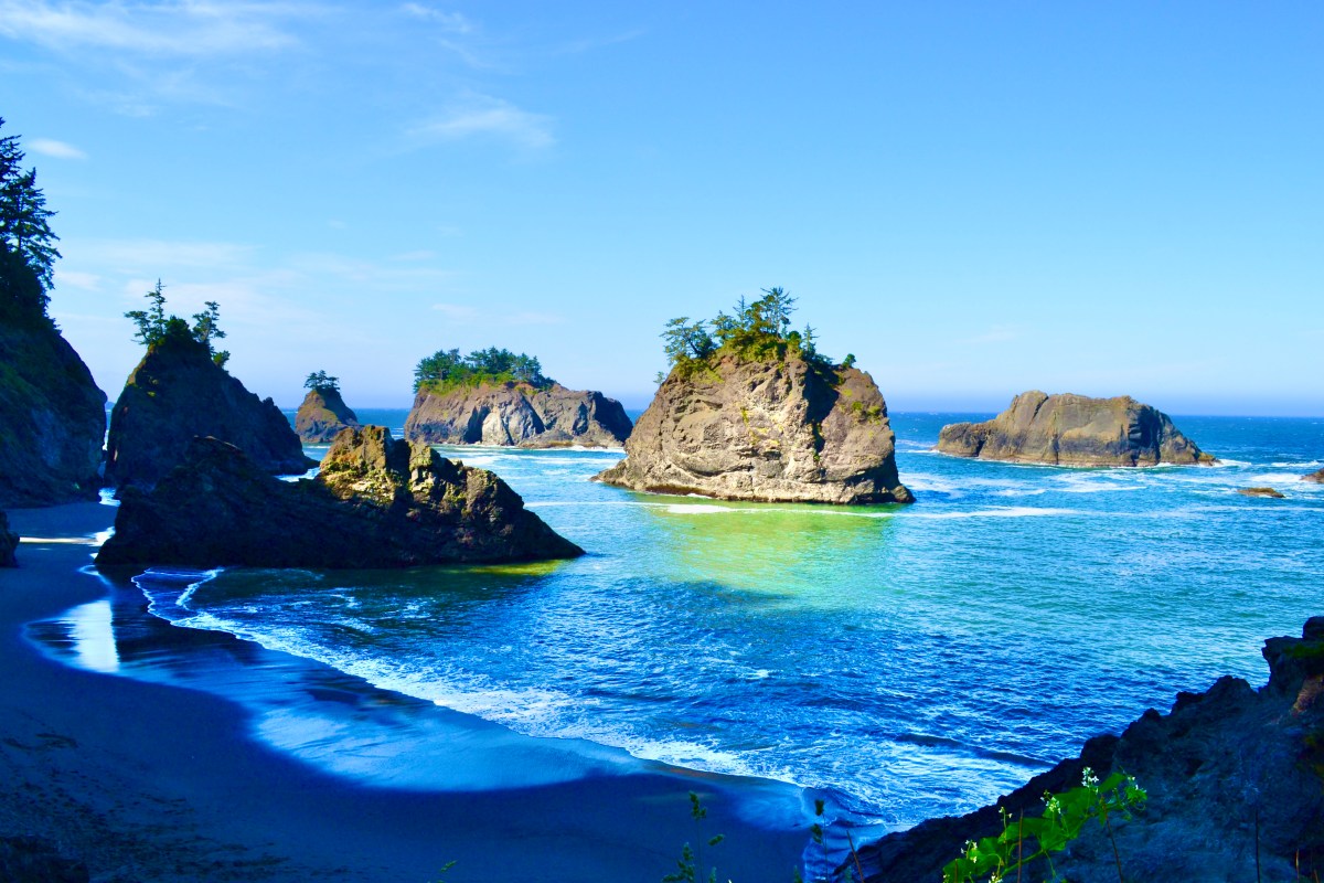
Secret Beach Oregon
A short descent from Highway 101 to a hidden cove in Samuel H. Boardman, where Miller Creek pours over the sand into the Pacific and basalt sea stacks shelter the beach from the wind.

At a Glance
Short Route
0.5 mi
Round trip
Full Trail
1.56 mi
With Thunder Rock
Elevation
30-374 ft
Short or full
Difficulty
Easy
Steep at end
Fee
Free
No pass required
Dogs
Allowed
On leash
Best Tide
Low
Check before going
Season
Year-Round
Open all year
The hike to Secret Beach Oregon is a short out-and-back trail in the Samuel H. Boardman State Scenic Corridor, roughly 0.5 miles round trip on the direct route, leading to a sheltered cove with a creek waterfall, basalt sea stacks, and frequent seal sightings. The trailhead sits on Highway 101 about 6 miles north of Brookings and 2 minutes north of the Natural Bridges pullout. Despite the name, this is one of the most consistently delivering coastal stops on the southern Oregon Coast.
What makes Secret Beach worth the trip is the geometry of the cove itself. Miller Creek tumbles over the cliff face directly onto the sand and into the surf, sea stacks rise 50 to 200 yards offshore, and the cliffs on either side wrap the beach into something that feels enclosed and private even on busy summer afternoons. Come at low tide and the experience expands dramatically: tidepools open up, sand bridges connect to additional pocket coves, and Thunder Rock Cove, just south, becomes accessible.
Should you hike Secret Beach?
Yes if
Skip it if
About Secret Beach
Secret Beach is a pocket cove on the southern Oregon Coast inside the Samuel H. Boardman State Scenic Corridor. What makes it different from the dozens of other turnouts along this stretch of Highway 101 is the combination of features in a single small space: a sand beach, a creek waterfall pouring directly off the cliff onto the sand, basalt sea stacks anchored offshore, and headlands that wrap the cove and shelter it from the prevailing wind.
The waterfall comes from Miller Creek, which runs out of the coastal forest above and tumbles over a short ledge of basalt before meeting the surf. In the right light you can watch the creek water mix with the Pacific in stark gradients of green and blue. The sea stacks sit between 50 and 200 yards offshore, breaking up the wave action and giving the beach a more enclosed, private feel than its open size would suggest.
Secret Beach gets a fraction of the visitors that better-known stops further north on the Oregon Coast pull in. On weekday mornings outside summer, you can have it almost entirely to yourself.

Where Is Secret Beach in Oregon?
Secret Beach is in Curry County on the southern Oregon Coast, inside the Samuel H. Boardman State Scenic Corridor. The trailhead pullout sits directly on Highway 101, about 6 miles north of Brookings and roughly 26 miles south of Gold Beach. The Natural Bridges pullout is about 2 minutes south on the same road.
If you are coming from Portland, plan on around 6.5 hours of driving (roughly 380 miles). The most scenic option is Highway 101 the whole way down. The faster option is I-5 south to Grants Pass, then Highway 199 through the redwoods to Crescent City, and finally Highway 101 north into Oregon. From Medford, it is about 2.5 hours over Highway 199. From Eugene, plan on around 4 hours.
GPS Coordinates: 42.1942, -124.3734
Not to be confused with: there are several other beaches called “Secret Beach” along the U.S. coast, most notably one in northern California south of Crescent City and one in Kauai. The Oregon Secret Beach is in Samuel H. Boardman corridor between Brookings and Gold Beach. If your search results mention sea cliffs and the Big Sur coast, that is a different beach in California.
Secret Beach Oregon Map
Getting There and Parking
The Secret Beach pullout is on the west side of Highway 101 (the ocean side), and it is small. It fits roughly 6 to 8 cars and there is no overflow lot. On summer weekends and during low-tide windows, it can fill quickly. Early morning, late afternoon, and weekdays are reliably easier.
On Google Maps, search “Secret Beach” with Oregon specified and the directions are accurate. Oregon’s southern coast does have spotty cell coverage in places, so it is worth downloading offline maps before you leave Brookings or Gold Beach.
Pro tip: there is no restroom at the Secret Beach pullout. Use the facilities in Brookings, at the Arch Rock Wayside, or at the Whaleshead Beach turnoff before you arrive.

The Secret Beach Trail
Trail Intel: Full Loop (1.56 mi)
Elevation Profile
From the pullout, the trail drops into coastal forest of Sitka spruce, salal, and salmonberry before opening onto the cliff above the cove. There is a fork early in the trail, and which way you take determines whether you do the short 0.5-mile route straight down to the beach or the full 1.56-mile loop that visits additional headland viewpoints and the descent to Thunder Rock Cove. The Secret Beach Trail listing on AllTrails covers the full route with current user reports.
I have done both routes more than once. The full loop is genuinely worth it if you have the time and the legs for the elevation, especially at low tide. The short route is the right call if you are short on time, traveling with kids, or just want the beach without committing to a longer hike.
Will, Oregon TailsShort Route: 0.5 miles, 30 ft elevation
The direct route down. Take the trail spur that drops straight toward the cove. The descent gets steep near the bottom and the last 50 feet onto the sand can be slick after rain. Most visitors do this version. From parking to standing on Secret Beach is about 10 minutes at a normal pace.
Full Trail: 1.56 miles, 374 ft elevation
The longer loop follows the headland trail north before circling back down. It adds a few overlook points, the access trail to Thunder Rock Cove, and noticeably more elevation change. Allow about an hour if you stop at the viewpoints. This is the version to do at low tide, when the cove access opens up.

For either route, good footwear and trekking poles matter more than they look like they should. The trail is steep at the bottom, and after coastal rain the dirt surface turns into slick mud that lasts for days. I have done it in trail runners and regretted it. Waterproof boots and a pair of poles make the descent comfortable instead of sketchy.
Gear for This Hike


Best Time to Visit Secret Beach Oregon
Secret Beach is open year-round, but two factors shape the experience more than season: tides and weather. Low tide is the single biggest variable. At low tide, the beach connects through to additional sea stacks and tidepools, the waterfall pools are walkable, and Thunder Rock Cove becomes accessible. At high tide, you get the main beach and the sea stacks but a lot of the wider experience disappears under water.
Spring (Mar-May)
Coastal wildflowers along the headland and a steady creek flow over the waterfall. Variable weather but consistently low crowds, especially on weekdays. The air is crisp and the rock colors are saturated after rain.
Summer (Jun-Aug)
The busiest season. Warmer, drier, and the small pullout can fill on weekend afternoons. Arrive before 10am or in the last few hours before sunset for easier parking and softer light. Miller Creek runs lower in late summer.
Fall (Sep-Nov)
Arguably the best balance. Crowds drop sharply after Labor Day, the light is golden by mid-afternoon, and storm systems start delivering dramatic ocean conditions. The waterfall recovers as rains return.
Winter (Dec-Feb)
Storm watching at its most cinematic, with the strongest waterfall flow of the year. Bring layers and waterproof boots. Trail can be slick. The pullout is rarely full and the beach often empty.
Tide tip: check a tide chart before you go. The Brookings-Chetco Cove tide forecast covers this stretch of coast accurately. Aim for a window within roughly 2 hours of low tide on either side. Anything below a 2-foot tide opens up the full corridor between the main beach, the offshore stacks, and Thunder Rock Cove. Stay aware of the incoming tide once you are on the beach. The cliffs at the back of the cove are not climbable, so getting cut off by a rising tide turns into a real problem.
How to read a tide chart for Secret Beach
Tides cycle every ~6 hours from peak to trough. To maximize beach time, arrive 1 to 2 hours before low tide and start your climb out roughly 90 minutes after the low. Free tide apps that work offline include Tide Charts and NOAA Tides.
Permits, Rules, and What’s Allowed
Secret Beach is part of Oregon’s state park system, which means a clear set of rules governs what you can and cannot do. The good news: most of the activities people associate with a coastal day trip are explicitly permitted.
Permits & Regulations
For current fishing seasons, shellfish biotoxin closures, and any temporary closures of the Boardman corridor, check Oregon Department of Fish & Wildlife and Oregon State Parks.
Wildlife at Secret Beach
The combination of low foot traffic and offshore sea stacks makes Secret Beach a dependable wildlife stop. Two species in particular are common enough that I would not be surprised to see them on any visit:
- Harbor seals hunt and rest in and around the offshore stacks. They are curious and will often pop their heads out of the surf to watch you. Keep at least 100 yards away if you can. Federal Marine Mammal Protection Act guidance applies along the entire Oregon Coast.
- Sea otters have been making a slow comeback along the southern Oregon Coast and are sometimes spotted in this stretch. They are smaller and more compact than seals and tend to float on their backs while feeding.
- Marine birds: black oystercatchers, cormorants, gulls, and the occasional bald eagle perched on the headland trees.
- Whales during gray whale migration windows (December–January and March–April). The headland viewpoints along the full loop trail are the better spots for whale watching than the beach itself.

Photography Tips for Secret Beach Oregon
Secret Beach is one of the most layered photography locations on the Oregon Coast, with beach, waterfall, sea stacks, headland, and wildlife all in a single small frame. A few things I’ve found that help:
- Go at low tide. The compositional opportunities at low tide are dramatically better. Reflections form in the wet sand, the waterfall pool widens, and you can shoot the sea stacks framed by the cove.
- The waterfall wants a slow shutter. A 1/4-second to 1-second exposure smooths the falling water and the wave action without losing the texture in the basalt. Bring a small tripod or a beanbag.
- Golden hour delivers. The cove faces roughly west. The 60 minutes before sunset light up the sea stacks and rim the headlands in warm orange. Plan your descent for an hour before sunset and stay through dusk.
- Drones are permitted in Samuel H. Boardman and the cove geometry rewards aerial perspective. The waterfall, beach, sea stacks, and headland all line up cleanly from 100 feet up.
- A polarizer matters here. The wet basalt around the waterfall and the surface of the offshore stacks both respond well to a polarizing filter, especially in afternoon light.
Nearby Hikes and Attractions
Secret Beach sits in the middle of the Samuel H. Boardman State Scenic Corridor. If you have a half day, several stops nearby pair naturally with this one. The most common pairing is Natural Bridges, just 2 minutes south, but they offer very different experiences:

Natural Bridges Oregon
2 minutes south on Hwy 101. A 50-foot walk to a viewpoint over multiple sea arches in a single cove. Best paired with Secret Beach as a half-day stop.

Samuel H. Boardman Corridor
The full corridor guide: Arch Rock, Whaleshead Beach, Indian Sands, Thunder Rock Cove, and more. One of the most scenic coastal drives in Oregon.
If you only have time for one additional stop, make it Natural Bridges. It is 2 minutes south on Highway 101 and the viewpoint is roughly 50 feet from the parking area.
Brookings Essentials: Eat, Stay, Refuel
Brookings is the closest town to Secret Beach (about 6 miles south) and the natural base for an overnight or a long day trip. The town has a working harbor, a small downtown, and the southern Oregon Coast’s “banana belt” microclimate, which is noticeably milder than the rest of the coast. Here are the spots people consistently come back to.
Eat
Where to grab a meal
- Black Trumpet Bistro
- Pacific Sushi & Grill
- Khun Thai
- Zola’s on the Water
- Oxenfrē Public House
Stay
Where to sleep
- Beachfront Inn
- Wild Rivers Motorlodge
- Brookings Inn Resort
- Tu Tu’ Tun Lodge (Gold Beach)
Practical
Fuel, coffee, supplies
- Gas
- Coffee
- Groceries
- Cell signal
Information cross-checked against the Oregon State Parks Samuel H. Boardman page and current tide tables from tide-forecast.com.
Last verified: Trail conditions, parking, tide guidance, and route details verified on the ground by Will, Oregon Tails (May 2026).
Oregon Tails Hiking
Hiking in Oregon
Trail guides, gear advice, and how-to articles for hiking across the state.
Browse hiking guidesGear Guide
Best Trekking Poles (2026)
Stability on steep, muddy terrain like this. Top picks reviewed and ranked.
See top picksFrequently Asked Questions
Secret Beach is in Curry County on the southern Oregon Coast, within the Samuel H. Boardman State Scenic Corridor. The trailhead is on Highway 101 about 6 miles north of Brookings, Oregon, and 2 minutes north of the Natural Bridges pullout.
From Highway 101, look for the small pullout on the west side of the road between Brookings and Gold Beach. Search Google Maps for Secret Beach. The trail descends through coastal forest, then opens onto the cove. Parking is limited to a small pullout that fits about 6 to 8 cars.
The short route to Secret Beach is approximately 0.5 miles round trip with about 30 feet of elevation change. The full Secret Beach Trail, which extends to additional viewpoints and Thunder Rock Cove, is 1.56 miles round trip with around 374 feet of elevation gain.
You can reach the main beach at high tide, but high tide significantly limits exploration. At low tide, the beach connects to Thunder Rock Cove and additional sea stacks become accessible. Plan your visit around low tide for the best experience and check tide tables before going.
Verified May 2026 · Oregon TailsNo, there is no entrance or parking fee. Secret Beach is part of the Samuel H. Boardman State Scenic Corridor, which is free to access year-round.
Yes, dogs are allowed on leash. Be mindful of seals and sea otters frequently spotted in the surf, and the steep, sometimes muddy trail down to the beach can be challenging for smaller dogs.
Drones are currently permitted in Samuel H. Boardman State Scenic Corridor, including Secret Beach. The cove and sea stacks make this a strong drone photography location, particularly at low tide and golden hour.
The closest town to Secret Beach is Brookings, Oregon, about 6 miles to the south. Gold Beach is approximately 26 miles to the north. The nearest major city inland is Medford, about 90 miles east over the Siskiyou Mountains.
Secret Beach is approximately 380 miles from Portland, about a 6.5 hour drive via Highway 101 along the coast, or via I-5 south then Highway 199 through the redwoods. It is often combined with a stay in Brookings or Gold Beach.
Wading and tidepooling are common, but full swimming is not recommended. The Pacific surf in this area is powerful and unpredictable, water temperatures are cold year-round, and rogue waves are a real risk along the rocky cove.