
Hiking God’s Thumb, Oregon Coast
A 4.3 mile out-and-back from a Lincoln City neighborhood through coastal forest and meadow to a basalt headland that hangs over the Pacific. The view is the easy part. The final scramble, the parking situation, and the rescue calls are why this guide exists.
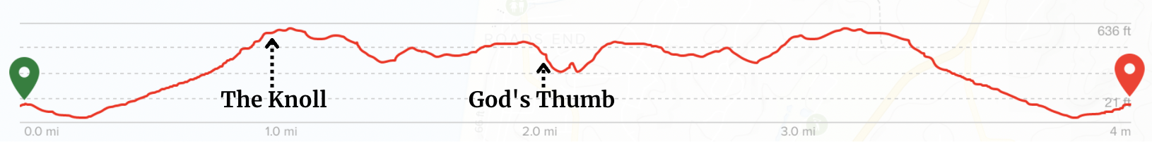
Trail Stats
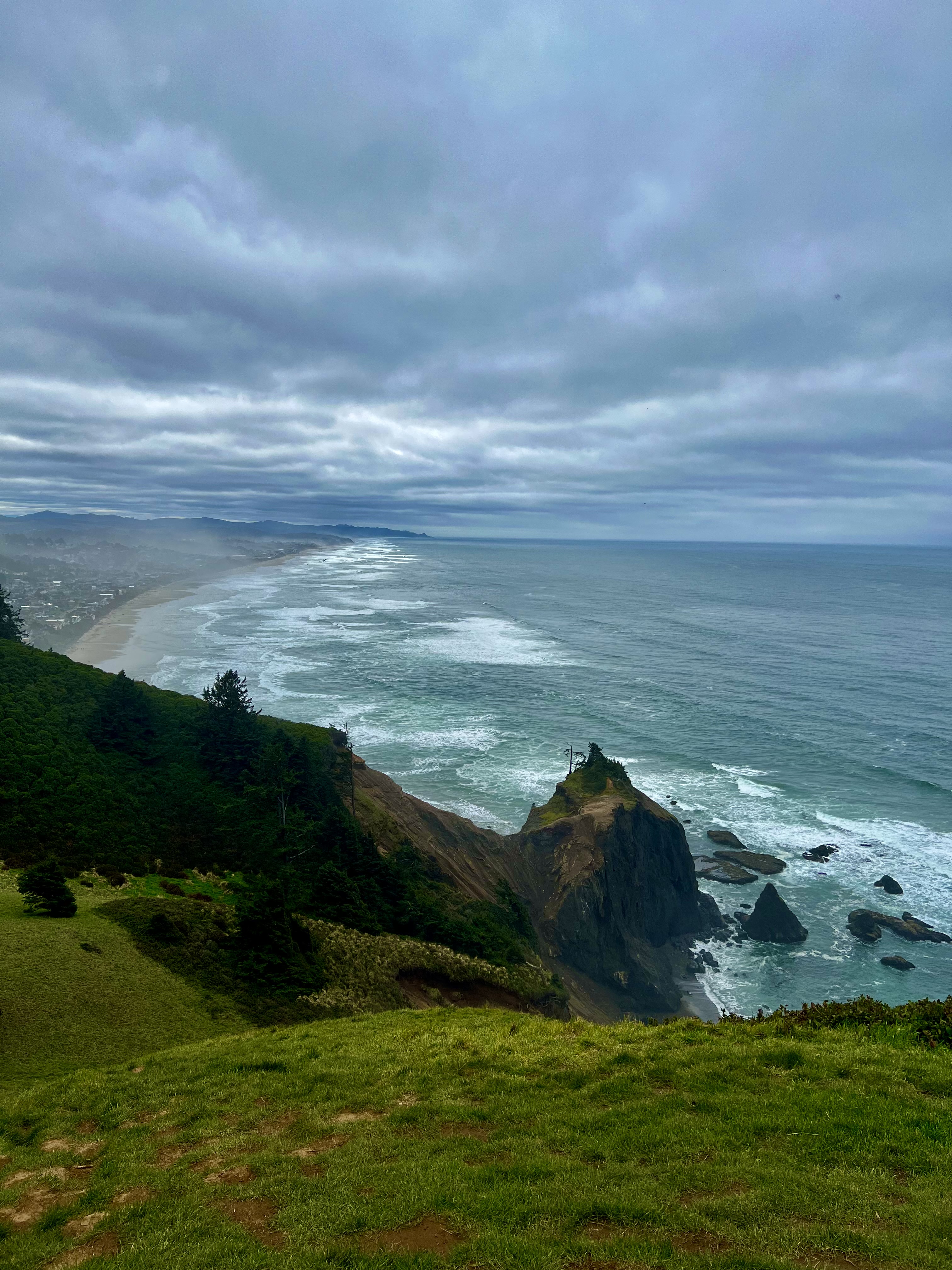
God’s Thumb is the kind of view that ruins other Oregon Coast hikes. A grass-topped basalt headland punching up out of the Pacific at the north edge of Lincoln City, with Cascade Head to the north, the entire Lincoln City coastline to the south, and a scatter of sea stacks below that look like the future of The Thumb itself. People hike it for sunset and remember it for years.
The trail is 4.3 miles round trip from the official trailhead at the end of NE Devils Lake Boulevard, with about 1,000 feet of cumulative elevation gain. Most of it is a gentle forest walk on the City of Lincoln City’s Knoll Trail. The last few hundred yards are a different animal: a steep, exposed, eroded scramble on what the Forest Service literally calls a “user-made” path. People get hurt up there. The Coast Guard has hoisted hikers off the cliff face. This guide treats that part with the seriousness it deserves.
A late-Eocene basalt dike, slowly becoming a sea stack
The Thumb is the southern remnant of a basalt dike formed during the late Eocene, roughly 38 to 34 million years ago. A vertical sheet of magma forced its way up through the surrounding rock, cooled into hard basalt, and stayed put. The cove and beach below were carved out when the dike was breached and wave action began gouging out the much softer siltstones and claystones of the Nestucca Formation that the dike had been protecting (per the Oregon Hikers Field Guide). The scattered stacks and pinnacles you can see in the surf below the summit are the same story still in progress.
Eventually The Thumb itself will share that fate. Wave erosion is slowly working through the softer rock at its base. The headland you stand on will be cut off from the mainland and become an isolated sea stack on a long enough timescale. The whole headland sits inside the Cascade Head Scenic Research Area, a 9,670-acre federally designated tract managed by the Siuslaw National Forest. The basalt formation has no official name; “God’s Thumb” and “The Thumb” are both colloquial. Locals have started using “The Thumb” by recommendation of the area’s trails-and-access proposal.
Getting there & parking
God’s Thumb is at the north end of Lincoln City, Oregon, on a mix of City of Lincoln City open space, private land, and Siuslaw National Forest within the Cascade Head Scenic Research Area. The trailhead sits inside a residential neighborhood. Public transit is not an option. Cell signal is reliable in town and gets spotty on the trail itself, so download offline maps before you leave the parking lot.
Drive times to the trailhead
God’s Thumb sits at the north end of Lincoln City inside the Cascade Head Scenic Research Area
Driving directions
From Highway 101 to the official trailhead
- From Highway 101 in Lincoln City, drive to the north end of town near Roads End State Recreation Site.
- Turn east on NE Devils Lake Boulevard. The turn is a few blocks north of NE Logan Road.
- Follow Devils Lake Boulevard about 1.2 miles all the way to the end. The road dead-ends in a residential cul-de-sac.
- This is the Villages at Cascade Head Trailhead, also called the official Knoll trailhead. Park along the curb. There is a port-a-potty at the trailhead.
- Do not block driveways. The neighborhood is the only reason this trail still has public access. Be quiet, pack out everything, walk on the road, not the lawns.
Three trailhead options, ranked:
Parking options for God’s Thumb. The cul-de-sac at the end of NE Devils Lake Boulevard is the recommended trailhead.
- NE Devils Lake Boulevard cul-de-sac (recommended). The official trailhead per godsthumb.info, the partnership site between the City of Lincoln City and the Forest Service. The cul-de-sac itself was originally built for a residential development that went into foreclosure; the City of Lincoln City bought over 500 acres of the surrounding land in 2013 to protect The Knoll. Parking here adds the full Knoll Trail to your route. About 4.3 miles round trip total.
- NE Sal La Sea Drive (limited, residential). A handful of legal curb spots about a mile shy of the Devils Lake lot. Shaves about 1 mile off the round trip but the neighborhood gets overrun on busy weekends. Park only in marked spots, do not block driveways. Locals have been pushing for stronger enforcement and access could be limited further.
- NE Logan Road shortcut (do not use). The trail from the end of Logan Road crosses private property and is no longer an authorized access route. There is no public parking on Logan Road outside the Roads End State Recreation Site, and using it risks both trespass and a tow.
GPS coordinates: 44.97398°N, 124.01287°W (the summit of The Thumb).
Restrooms: None at any of the trailheads. Closest public restrooms are at Roads End State Recreation Site on NE Logan Road, about a five minute drive from the Devils Lake trailhead.
Cell service: Reliable in the residential area at the trailhead. Drops out in the forest sections and at The Thumb depending on carrier.
Fees: None. No Northwest Forest Pass required.
Trail walkthrough, mile by mile
The hike is long enough to feel like a real outing but easy enough that the navigation matters more than the fitness. The trail is unsigned for The Thumb itself; you are looking for The Knoll, then continuing past it. Here is what each section feels like, from the cul-de-sac on Devils Lake Boulevard to the basalt summit.
Trailhead to The Knoll
From the cul-de-sac at the end of NE Devils Lake Boulevard, the Knoll Trail starts at the gate. Take the trail at the first turn-off and follow the wide path through forest. At the first split, go right for The Knoll and The Thumb. The trail climbs gently through second-growth coastal forest with mossy spruce and fern understory until it opens onto a wide grassy ridge. This is The Knoll. The view here is already excellent, with Devils Lake and the entire Lincoln City coastline laid out below. Many hikers turn around here, and there is no shame in it. Watch for elk in the early morning.
The forest descent and bluff
Past The Knoll the trail is no longer USFS-maintained. It dips back into spruce and alder, descends through an alder-meadow section that holds mud well into summer, then climbs again toward an open bluff overlooking the ocean. This is the natural turnaround point if conditions are wet, windy, or you are hiking with kids. The view here covers most of what you came for: Cascade Head to the north, the Salmon River estuary, and the Lincoln City beaches stretching south. The Thumb itself is visible from here.

The narrow ridge approach
From the bluff, the trail traces a narrow eroded ridge toward the base of The Thumb. Loose dirt, slick spots, and no railing. The right side of the trail drops steeply toward the cove. Take it slow, especially in wind. Stay on the established tread, narrow as it is. Cutting around it makes the erosion worse, and the Forest Service has signage explicitly asking hikers not to widen the path. By the end of this stretch you arrive at the saddle below the final climb.
The final scramble
The last few hundred feet are the hardest part of the hike, and the part that has produced multiple cliff rescues. The path is steep, eroded, and exposed. Several deep grooves are cut into the dirt where the trail has eroded under heavy use. The summit itself is a flat grass-topped headland that can hold maybe five people at a time without anyone feeling crowded. There are no fences. The drop on the north and west sides is hundreds of feet to rocks and surf. Stay back from the edges. Sit down to enjoy the view; do not stand at the perimeter.

Best time to visit
God’s Thumb is open year-round, but the trail is more seasonal than the calendar suggests. The forest sections hold mud well into early summer and the user-made section to The Thumb gets dangerous in wet conditions. The wrong week can mean a soaked bluff hike at best, a slip-and-fall on the final scramble at worst.
| Season | Months | Conditions | Verdict |
|---|---|---|---|
| Spring | Apr – May | Wildflowers in the meadows and on The Knoll. Mud lingers on the user-made trail well into May. Final scramble can still be slick. Generally open with caution. | |
| Summer | Jun – Sep | Driest tread, longest light, and the trail’s signature sunset window. Crowds peak on weekends. The single best season for a first visit. | |
| Fall | Oct – Nov | Quieter trails, lower light, dramatic skies. Storms roll in fast off the Pacific. Watch the forecast and be prepared to turn around at the bluff. | |
| Winter | Dec – Mar | Mud-soaked Knoll Trail and a final scramble that becomes legitimately dangerous when wet. Wind on the summit can be punishing. The hike to The Knoll is fine; the push to The Thumb often is not. |
Sunset is the trail’s signature time of day. The headland faces west into the Pacific, the meadow lights up gold in the last hour, and the sea stacks below catch silhouette light. Plan to arrive at the summit at least 30 minutes before sunset, account for the descent in fading light, and bring a headlamp. The final scramble is not somewhere to rush in twilight.
Safety: the final scramble and the rescue calls
This is the part of the hike that produces helicopter rescues.
The Coast Guard and North Lincoln Fire and Rescue have hoisted multiple hikers off the cliff face below The Thumb in recent years, including a teen rescued in March 2026, two teens plus a stuck firefighter in July 2025, and reports of six similar emergency calls between mid-2024 and mid-2025 alone. People slip on loose rock, fall partway down the north face, and break bones. The trail itself is fine. The final climb and the unfenced summit edges are where the danger lives.
The Hebo Ranger District has signage on the user-made trail explicitly warning that it is “not to code” and used at your own risk. Stay on the established tread, no matter how narrow. Never trust loose rocks, vegetation, or branches as handholds. Stay back from the edges of the summit and never lean out for a photo.
Three things that filter the bad days from the rescue days: turn around at the bluff if it is wet or windy, hike with at least one other person, and tell someone your route and return time. There is spotty cell service on the final ridge depending on carrier, and the closest paramedic response is a 15-minute drive away.
Trail access etiquette is its own kind of safety. The Devils Lake Boulevard trailhead exists because the surrounding neighborhood tolerates it. Park only in legal spots, do not block driveways, keep noise down, pack out everything including dog waste, and walk on the road rather than the lawns. The faster the neighborhood feels overrun, the more likely access tightens. The Logan Road shortcut is private property, has no public parking, and is not an alternative.
Hiking with dogs
Dogs are welcome on a leash on both the Knoll Trail (City of Lincoln City open space) and the user-made trail to The Thumb. Most of the route is a comfortable forest walk that fit dogs handle easily. The catch is the final scramble: it is too steep, too eroded, and too exposed for most dogs to climb safely, and there is no leash position that gives you control if your dog slips on the upper section.
The honest answer for most dog owners is to turn around at the bluff overlook on the approach ridge. The view from there is excellent. If you are committed to summiting with a partner, leave one person and the dog at the bluff while the other climbs. At any point on the trail, keep dogs leashed for elk encounters in The Knoll meadow and to keep paws off the eroded user-made tread.
Photographer’s notes
God’s Thumb is a sunset hike disguised as a daytime trail. The light, the headland geometry, and the layered coastline all line up for the last hour of the day. A few things that make the difference between a good photo and the photo people remember.
- Shoot the panorama from the bluff, not the summit. The classic God’s Thumb photo (the one in our hero) is taken from the approach ridge looking back at the headland with the surf below. The summit itself is the place to be; the bluff is the place to shoot the headland from.
- Sunset is the assignment. The west-facing summit catches the entire setting sun. Aim to arrive 45 to 60 minutes before sunset, set up on the bluff, then move to the summit when the color starts breaking. Stay through afterglow.
- Go wide, then go tight. A 16 to 24mm full-frame equivalent captures the headland and the coastline in one frame. Switch to 70 to 100mm for compressed shots of the sea stacks below The Thumb that show the future of the headland.
- Include the texture. The grass on the summit, the basalt edges, and the alder meadow on the approach all give scale and foreground when paired with the open ocean. Get low, foreground something.
- Drone with restraint. The trail crosses City of Lincoln City open space and Siuslaw National Forest land that allows recreational drone use, but the area is heavily used and the Forest Service has signage discouraging off-trail activity. Fly only when the summit is empty, fly low, finish in five minutes, and stop immediately if anyone asks. This is not the trail to be the drone person.
What to pack for God’s Thumb
This is a short hike with a few pieces of gear that genuinely earn their spot. Treat the mud and the sunset finish as the two design constraints.
Nearby trails to combine
The north Lincoln City coast has more than enough to fill a long weekend. If you have driven this far, stack at least one other stop on the trip.
Frequently asked questions
How long is the God’s Thumb hike?
How hard is the God’s Thumb hike?
Where is the official God’s Thumb trailhead?
Can I park on Sal La Sea Drive instead?
Why can’t I use the Logan Road trail?
Are there bathrooms at the trailhead?
Is there cell service on the God’s Thumb trail?
Is God’s Thumb dog friendly?
How dangerous is God’s Thumb?
When is the best time to hike God’s Thumb?
What is The Knoll versus God’s Thumb?
Can you fly a drone at God’s Thumb?
Is God’s Thumb worth the hike?
What is God’s Thumb made of?
Last updated: May 2026 · Trail conditions, parking access, and trailhead etiquette can change quickly. The Knoll Trail is City of Lincoln City open space; the trail to The Thumb is a user-made route inside the Cascade Head Scenic Research Area. For current trailhead and access info, check godsthumb.info, the partnership site between the City of Lincoln City and the Forest Service.