Oregon Hikes · Waterfall Guide
The Best Oregon Waterfall Hikes
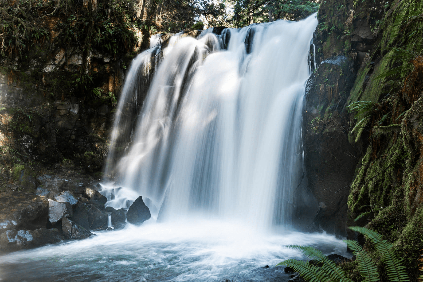
Twenty-four waterfalls worth the drive, from the 620-foot drop of Multnomah to the hidden cathedrals of the Coast Range. Stats, permits, current trail status, and our honest favorites.
Oregon has more than 1,000 named waterfalls. Most of them in the Cascade Range and Columbia Gorge, with a smaller cluster of giants in the Coast Range. The list below covers the 24 best waterfall hikes worth the drive, organized roughly by name recognition and ranked from “must-see” to “off-the-beaten-path.” Every entry includes verified distance, height, difficulty, and current trail status.
A note on closures: the December 2025 atmospheric-river storms and the lingering effects of the 2017 Eagle Creek and 2020 Beachie Creek fires have closed several trails on this list. We’ve flagged each one prominently. Always check the U.S. Forest Service alerts for the relevant national forest before you drive.
If you want a single drive that strings together more than a dozen waterfalls in one shot, see our companion guide to Oregon’s Waterfall Highway on Highway 138 in the southern Cascades.
The List
The Best Waterfall Hikes in Oregon, 2026
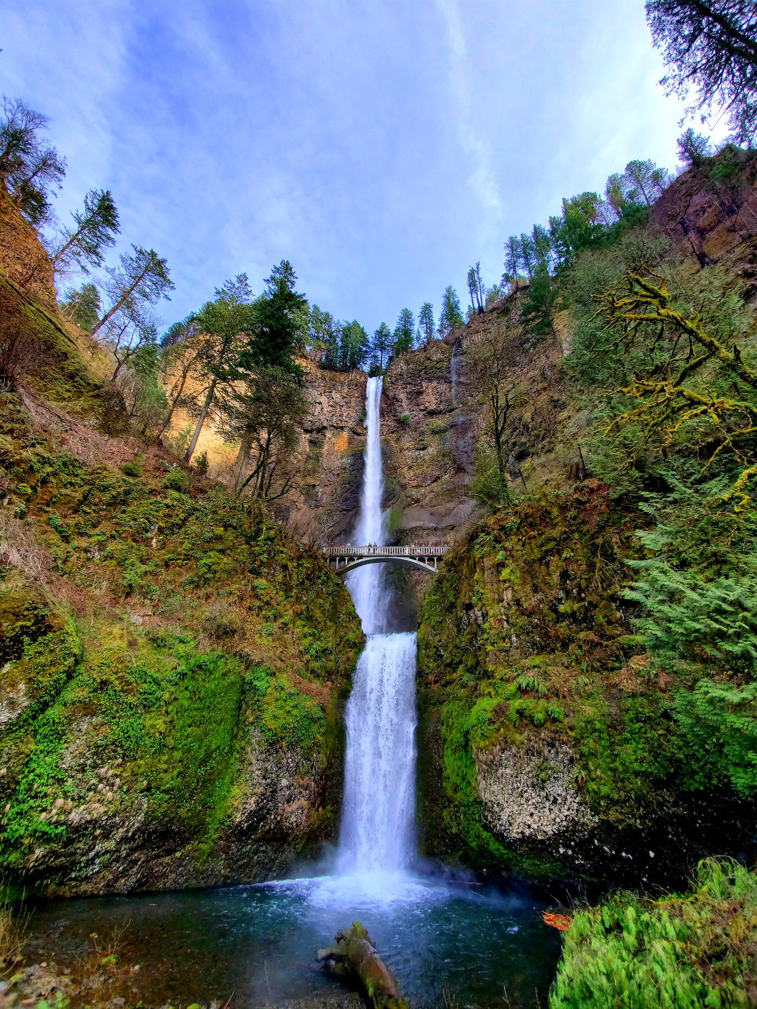
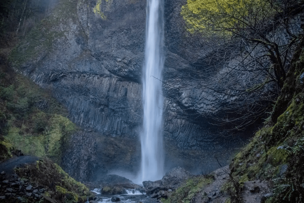
Multnomah Falls
Oregon’s tallest waterfall and most-visited natural attraction in the Pacific Northwest.
Timed Entry Permit Required May 22 to Sept 7, 2026
A $2 Multnomah Falls timed use permit is required to park in the I-84 Exit 31 lot between 9 AM and 6 PM. Reserve up to 14 days ahead on Recreation.gov. The Historic Columbia River Highway east of Multnomah is closed for viaduct repairs through spring 2026.
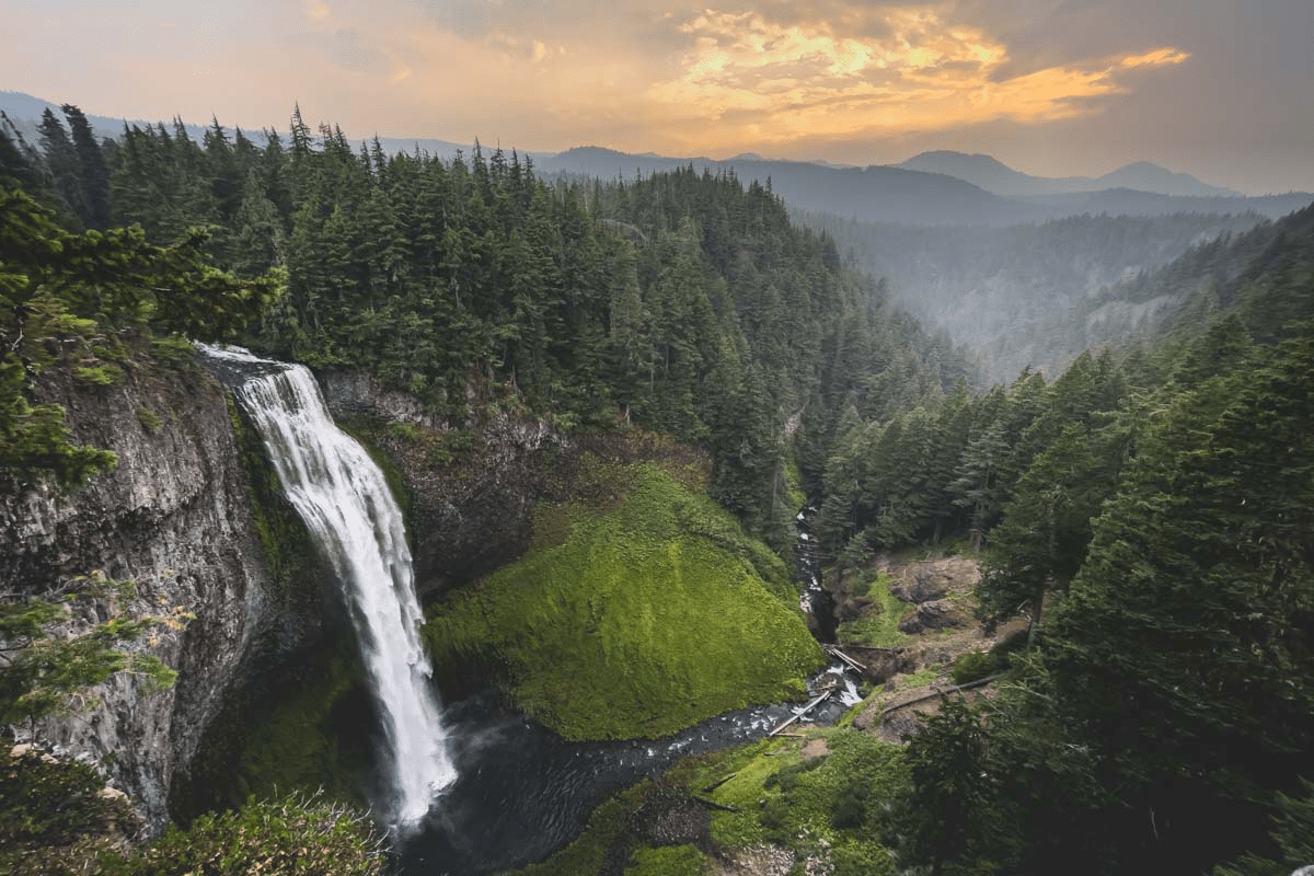
Multnomah Falls is the centerpiece of any Oregon waterfall list. The two-tiered plunge drops 542 feet in the upper falls, 9 feet in a connecting cascade, and 69 feet in the lower falls, for 620 feet total of water hurling off basalt cliffs east of Portland. Two million people visit each year, and the Forest Service credits it as the second-tallest year-round waterfall in the United States, although the World Waterfall Database disputes that ranking.
The flat, paved approach from the I-84 lot to the lower viewpoint takes minutes. The Benson Bridge sits 105 feet above the lower cascade and offers the iconic view straight up the upper falls. From there, eleven switchbacks climb 1.2 miles and 800 feet to the overlook at the top, a steep but well-graded round trip of 2.4 miles. Photographers love March and April, when winter rain and snowmelt drive peak flow; February sometimes brings dramatic ice formations on the cliff face.
Parking fills early. The Columbia Gorge Express bus from Portland’s Gateway Transit Center runs to Multnomah Falls without requiring a permit, and a free shuttle connects from Bridal Veil. So does arriving by bicycle. If you skip the permit and the bus, plan to come before 8 AM or after 7 PM during permit season.
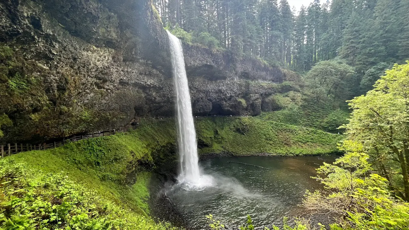
Silver Falls
The Trail of Ten Falls: the most concentrated waterfall hike in Oregon.
Silver Falls State Park is the crown jewel of the Oregon State Park system, and the Trail of Ten Falls is the reason. The 7.2-mile loop visits ten waterfalls in a single basalt-lined canyon, four of which the trail passes behind. South Falls (177 feet) is the headliner and the most photographed; Lower South, Lower North, North, Twin, Middle North, Drake, Double, and Winter round out the list.
Parking at the South Falls Day Use Area requires the standard $5 day-use fee or an Oregon State Parks annual pass. Restrooms, a café, and a historic CCC-built lodge sit at the trailhead. Dogs are allowed on the Rim Trail but not on the Canyon Trail. That rule is worth respecting because the canyon trail is heavily eroded and slick.
Spring and early summer deliver peak water; fall brings yellow bigleaf maples lining the gorge. Winter visits are spectacular when the falls partially freeze, but the Canyon Trail can be treacherous in icy conditions and may be closed.
Proxy Falls
A 226-foot ribbon falling over a moss-draped lava cliff in the Three Sisters Wilderness.
Three Permits Required, Plus Seasonal Road Closure
From June 15 to Oct 15: a Central Cascades Wilderness Day-Use Permit (book at Recreation.gov), a free self-issue trailhead permit, and a $5 NW Forest Pass at the parking area. McKenzie Highway 242 closes in winter, typically late October through late June, making the trailhead inaccessible by car.
Proxy Falls is the most photogenic short hike in central Oregon. The 1.6-mile loop crosses an old lava field on the western edge of the Three Sisters Wilderness before forking to two viewpoints: the upper splits down a wider apron, while the lower drops in a single 226-foot ribbon over moss-coated basalt. Water from the pool below mysteriously vanishes into the porous lava bed, with no visible outlet.
The trail’s biggest issue isn’t difficulty. It’s logistics. The Central Cascades Wilderness Permit system is designed to limit crowds during peak season, and day-use permits release in 10-day and 2-day rolling windows on Recreation.gov. Set an alarm. The trailhead also sits along Highway 242, a winding McKenzie Pass byway that closes in winter and usually doesn’t reopen until late June.
Once you’re there, plan an hour for the loop and another half hour for photographs. Late June through July offers strong flow; by September the falls thin considerably.
Wahclella Falls
A thunderous gorge waterfall pouring out of a slot canyon in the Columbia Gorge.
Trail Closed Indefinitely by Forest Order
Wahclella Falls Trail #436 was severely damaged in the December 2025 atmospheric-river storms. Two trail bridges sustained heavy damage and approximately 150 feet of trail tread washed out across multiple sections. The trail will likely remain closed for months. Check the USFS Columbia River Gorge alerts page before planning a visit.
Wahclella Falls is one of the Columbia Gorge’s most powerful cascades, pouring out of a narrow basalt slot into a semicircular amphitheater. The U.S. Forest Service cites the combined height at 350 feet, with the lower horsetail tier dropping about 60 feet into a churning splash pool; the upper tier (15-25 feet) is partly hidden in the chasm. Other authoritative surveys put the figure closer to 127 feet. The discrepancy comes down to whether you count the hidden upper tier.
Under normal conditions, the lollipop trail covers 1.8 miles round trip with mild elevation gain along Tanner Creek. The path passes Munra Falls, a slim cascade tumbling right next to the bridge, before opening into the Wahclella amphitheater.
Once Trail #436 reopens, plan around a $5 day-use fee at the trailhead (or an interagency pass). The 2017 Eagle Creek Fire burned hot in this drainage, so flash-flood and rockfall risks remain elevated for several years following heavy rain or snow.
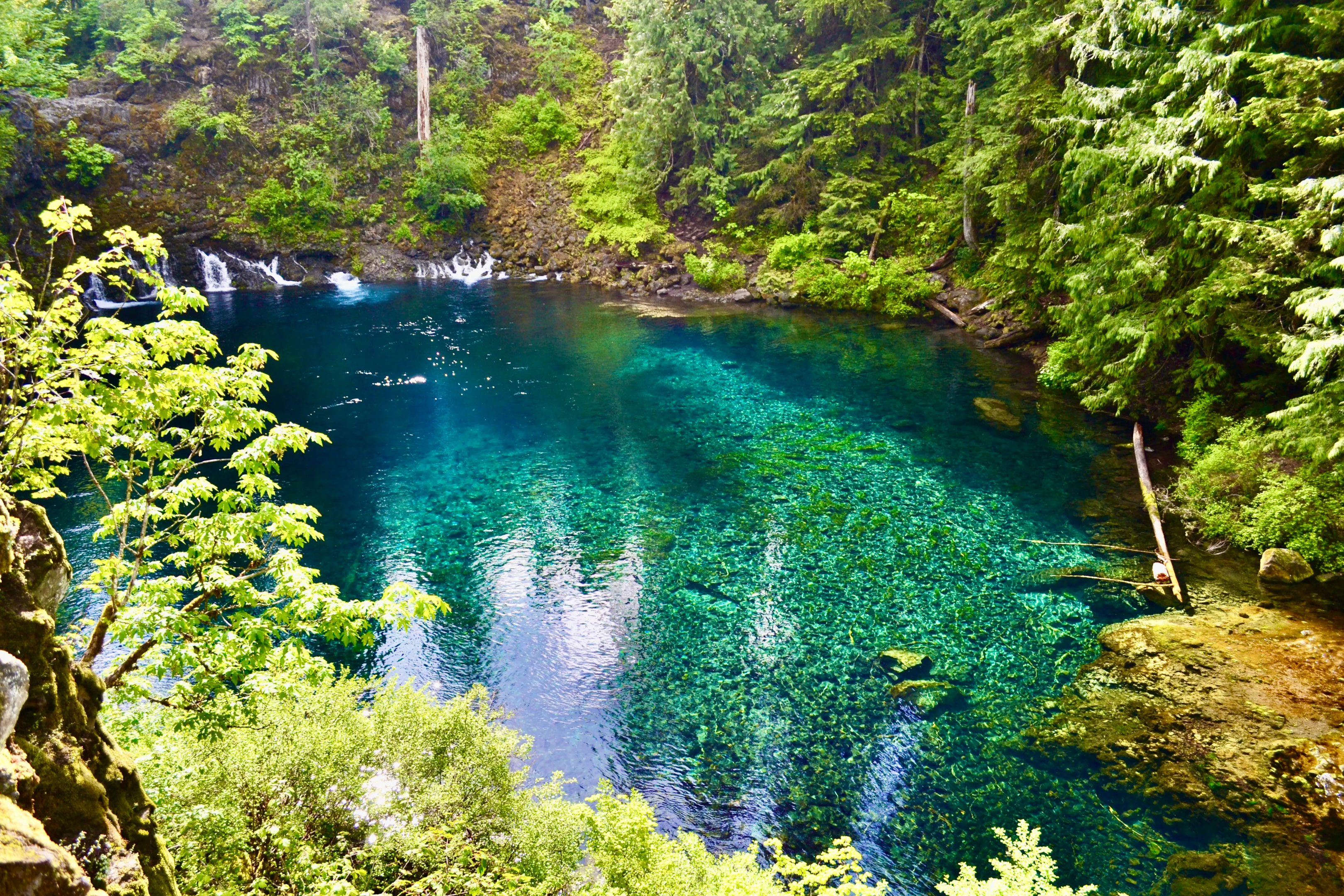
Tamolitch Falls (Blue Pool)
A turquoise spring-fed pool where the McKenzie River reemerges from underground.
Hypothermia and Cliff-Diving Hazards
Water temperature stays at 37 to 42°F year-round and the pool is 30 feet deep at the center. Multiple deaths and serious injuries have occurred from cliff jumping. The pool is not a swimming hole; even brief immersion can cause cold-shock incapacitation.
Blue Pool is one of those places that doesn’t quite look real. The McKenzie River disappears into a 1,600-year-old lava flow north of Carmen Reservoir and reemerges through underground springs at the base of a dry basalt cliff. Tamolitch Falls only flows after exceptionally wet winters. The water that fills the pool below is so clear and so cold it appears to glow turquoise from above.
The standard route is a 4.2-mile out-and-back from the McKenzie River Trailhead at Trail Bridge Reservoir. The path follows the river through old-growth Douglas-fir and incense cedar before climbing onto the lava bed itself. Footing gets tricky on the rocky last half-mile. No permits are required, but the small lot fills early on summer weekends; a second access from Carmen Reservoir adds distance but offers solitude.
Photograph from the cliffs above. Stay on the trail. Treat the pool with the seriousness it deserves.
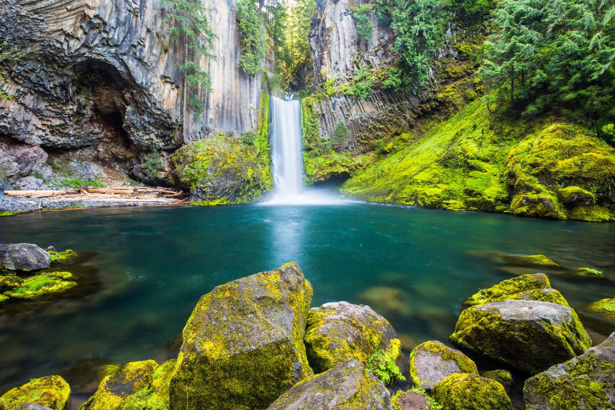
Toketee Falls
A two-tiered plunge framed by columnar basalt, one of Oregon’s most photographed falls.
Stay Behind the Fence
200+ stairs lead to a single elevated viewing platform. A user-cut path drops to the base, but it’s behind a clearly marked fence and there has been a fatality from a hiker descending the unofficial route. The view from the platform is the view.
Toketee, the Chinook word for graceful, earns the name. The North Umpqua carved a perfect amphitheater out of layered lava flows, and the river drops in two stages: a 28-foot upper tier into a deep alcove, then an 85-foot plunge into the pool below. Hexagonal basalt columns frame both tiers like a cathedral.
The trail is short (under a mile round trip) but built almost entirely as constructed wooden stairs and walkways through old-growth Douglas-fir and red cedar. Count on roughly 200 stairs each way. The viewing platform is unique among Oregon waterfalls: you look down at the upper falls rather than up.
A massive wooden penstock pipeline, leaking rainbow-tinged spray, sits in the parking lot itself: it diverts much of the North Umpqua’s flow to a downstream powerhouse, which is why Toketee runs at consistent volume year-round. No permit fees apply. Restrooms are at the trailhead.
Abiqua Falls
A 92-foot plunge into a basalt amphitheater, the reward for a rough drive and steep scramble.
Private Land, Public Sale Pending
Abiqua Falls sits on private property currently owned by the Abbey Foundation of Oregon. Public access is allowed but not guaranteed. As of March 2026, the State of Oregon is moving to purchase the land via Senate Bill 5701. Reaching the trailhead requires a high-clearance 4WD vehicle. Without one, parking at Crooked Finger OHV Area adds about 3.5 miles each way. The descent requires fixed ropes.
Abiqua sits at the bottom of a circular basalt amphitheater, dropping 92 feet over a sharp lip of columnar rock. It’s one of Oregon’s most cinematic waterfalls and one of its hardest to reach.
From the upper trailhead, the hike is just 0.7 miles round trip, but those miles are nearly vertical, with multiple fixed ropes anchored along the steepest sections to help hikers descend the loose, root-covered slope. Bring sturdy traction, gloves, and hiking poles. Wear clothes you don’t mind getting muddy. The final approach involves walking up the creek bed itself.
Do not bring children, dogs, or anyone with mobility limitations. Stay on the established route. Landowners’ continued tolerance of public access depends on hikers respecting boundaries.
Sahalie & Koosah Falls
Two thundering waterfalls a half-mile apart on the upper McKenzie River.
Sahalie (heaven, in Chinook Jargon) and Koosah (sky) sit a half-mile apart on the upper McKenzie River, both products of basaltic-andesite lava flows that dammed the river roughly 3,000 years ago. Sahalie is the upper of the pair: a 100-foot cascade of pure white foam pouring over a natural lava dam. Koosah, downstream, drops 70 feet into a wide amphitheater with multiple viewpoints.
The 2.6-mile Waterfalls Loop connects both, crossing the river on a sturdy footbridge above Sahalie and looping back along the McKenzie River Trail. Sahalie’s main viewing platform is wheelchair-accessible from the parking lot; the rest of the loop has stairs and exposed roots. No permits required. Parking at Sahalie fills first; Koosah’s lot is usually less crowded.
The McKenzie runs hard year-round thanks to underground springs, so you’ll never catch these two with low flow. Sahalie also stars in the 1993 Disney film Homeward Bound, if you need a piece of trivia for the trailhead.
Latourell Falls
A 224-foot column of water plunging over chartreuse-lichen basalt, the closest major Gorge falls to Portland.
Latourell is the first major waterfall east of Portland on the Historic Columbia River Highway, and the only one where the basalt cliff itself becomes part of the photograph: an unmistakable wall of bright chartreuse lichen glows around the falls like a reflective surface.
Lower Latourell drops 224 feet in a single columnar plunge, just steps from the parking lot. The 2.4-mile loop continues uphill to Upper Latourell, a smaller two-tiered cascade, and returns through Guy W. Talbot State Park‘s grassy picnic area beneath the historic 1914 highway bridge. Trail conditions are wet most of the year and the rocks at the base of the lower falls turn slippery quickly.
No permits are required and no fees apply. The parking lot is small for a state park trailhead this close to Portland, so weekday mornings or late afternoons are far easier. Spur trails to the lip of the falls have been closed in recent years for safety reasons.

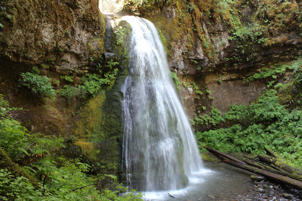
Tamanawas Falls
A wide curtain falling into an amphitheater on the east side of Mount Hood.
Main Trail Closed, Detour Available
Tamanawas Falls Trail #650A is closed indefinitely after multiple slides and a complete trail washout in the December 2025 storms. The East Fork Trail #650 also has a bridge washout. Detour: start from Polallie Trailhead, hike Elk Meadows Trail #645, then take Tamanawas Tie Trail #650B to the falls. The detour is roughly 4 miles round trip, longer and more challenging than the standard route.
Tamanawas (Chinook for guardian spirit) is one of the few major Mount Hood waterfalls visible from below. Cold Spring Creek pours over a 100-foot lava ledge into a wide amphitheater that visitors can walk right up to in summer or hike behind a curtain of ice in winter. The basalt is massive, the spray is fierce, and the talus field beneath the falls makes the final approach a careful step-by-step exercise.
Until the December 2025 washouts, the standard route ran 3.6 miles round trip from the Tamanawas Falls Trailhead on Highway 35. That trail is now blocked by multiple slides. The Polallie detour delivers hikers via Elk Meadows Trail #645 and a connection through the Tamanawas Tie #650B; expect a steeper grade and rougher tread until repairs are completed.
Year-round Recreation Pass required at the Tamanawas Falls Trailhead. Sno-Park Permit required November 1 through April 30. Microspikes are essential for winter visits. The spray freezes thick over the rocks.
Punchbowl Falls
An iconic emerald pool below cliffside falls on the Eagle Creek Trail.
Eagle Creek Trail #440 Closed Indefinitely
The entire Eagle Creek Trail to Punchbowl Falls is closed under USFS Forest Order due to extensive December 2025 storm damage. Multiple landslides have completely blocked the trail; locked gates and signage are in place at the trailhead. The Pacific Crest Trail Association is coordinating volunteer work parties for restoration.
Punchbowl Falls is the photo at the head of nearly every Oregon hiking guide: a 33-foot plunge into a perfectly round emerald pool, walls of basalt rising on three sides. The standard 3.8-mile round-trip route follows the historic Eagle Creek Trail #440, blasted into cliffsides by Civilian Conservation Corps crews a century ago, with cable handrails along the most exposed sections.
The trail has had a hard decade. The 2017 Eagle Creek Fire scorched the entire drainage. A 2018 landslide reshaped the lower pool. The December 2025 atmospheric-river storms then took out additional sections entirely. Even when reopened, this trail is not for unleashed dogs, small children, or anyone uncomfortable with exposed cliffside footing.
When access returns, expect a $5 NW Forest Pass at the trailhead. Cliff diving is prohibited at Punchbowl and has long been the cause of fatalities here.

Drift Creek Falls
A 75-foot waterfall viewed from Oregon’s longest pedestrian suspension bridge.
Drift Creek Falls is the closest thing the Oregon Coast Range has to a theme-park experience that nature put together itself. The trail descends gently through Sitka spruce and big-leaf maple to a 240-foot suspension bridge, the longest pedestrian suspension bridge in Oregon, strung 100 feet above the creek bed. Looking right from the deck, the 75-foot waterfall plunges off a basalt cliff into a rocky bowl below.
The hike is 3 miles round trip with about 480 feet of elevation gain. It’s downhill on the way in, uphill on the way back. A short spur after the bridge drops to the base of the falls, where a fallen-log picnic table sits in the spray zone. The bridge itself is sturdy enough to support 165,000 pounds and incorporates a stiffening truss for stability, but it sways noticeably underfoot.
$5 NW Forest Pass required at the trailhead. The drive in winds along narrow gravel forest service roads. Leave navigation downloaded ahead of time, because cell service vanishes about 10 miles before the parking area.
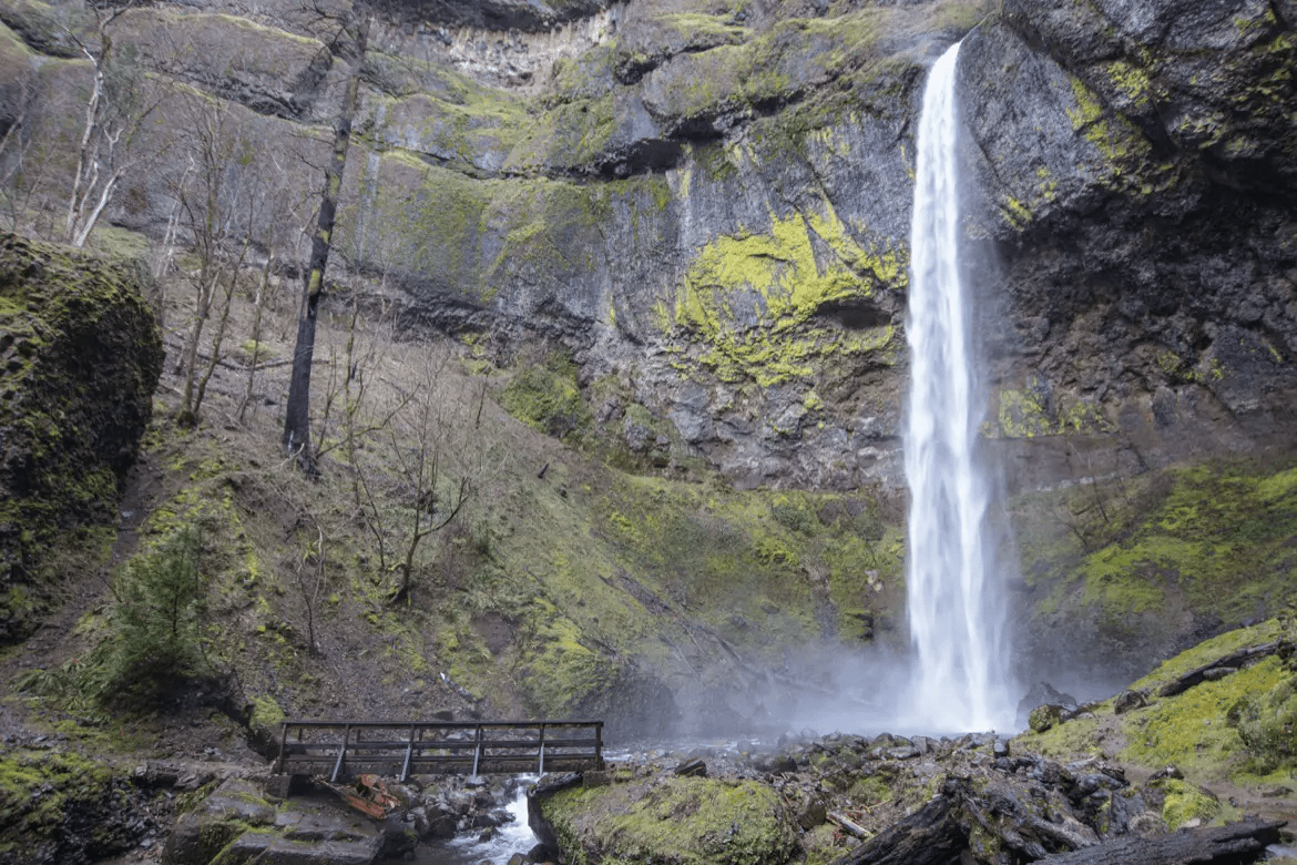
Elowah Falls
A 213-foot plunge into a moss-walled amphitheater, the quiet alternative to Multnomah.
Elowah is the underrated counterpart to Multnomah. The 213-foot plunge drops into a circular amphitheater so coated in moss it appears almost upholstered, and the trailhead at John B. Yeon State Park sees a fraction of the traffic 15 miles to the west. The 2017 Eagle Creek Fire burned through this drainage but the regrowth is well underway, and the trail itself was rebuilt in stages between 2018 and 2022.
The standard route is 1.4 miles round trip with about 400 feet of gain. Short, but with a few exposed switchbacks where the trail traces the cliff. A second option from the same trailhead climbs to Upper McCord Creek Falls (1.9 miles round trip), a delicate twin-stream cascade with sweeping Columbia River views.
The Historic Columbia River Highway State Trail between John B. Yeon and Toothrock is closed through summer 2026 for the I-84E McCord Creek bridge replacement, but trail access to Elowah Falls itself remains open.
Marion Falls
A two-stage drop on Marion Creek deep in the Mt. Jefferson Wilderness.
Central Cascades Permit Required June 15 to Oct 15
A Central Cascades Wilderness Day-Use Permit is required, plus a $5 NW Forest Pass at the trailhead. Permits release in 10-day and 2-day rolling windows on Recreation.gov. The falls are reached via an unsigned, unmaintained user trail off the Marion Outlet Trail, bring an offline map.
Marion Falls hides at the end of an unmarked spur on the way to Marion Lake, the largest lake in any Oregon wilderness area. The official trail follows Marion Lake Trail #3436 through old-growth Douglas-fir, past Lake Ann’s underground outlet, and out to the lake itself. The unsigned spur to Marion Falls drops off the Marion Outlet Trail to a steep, slippery descent through fallen timber.
The reward is a stacked view: Marion Falls plunges first, then Gatch Falls drops directly below it, for two waterfalls in a single frame. The 5.4-mile round trip includes about 1,000 feet of elevation gain. Some of the route runs through 2003 B&B Fire and 2006 Puzzle Fire burn scars, where standing dead trees still pose hazards in high winds.
This is not a beginner navigation route. The user trail to the falls is faint, slippery, and prone to log obstacles. Bring traction, an offline map, and good judgment about turning back if conditions feel unsafe.
Salt Creek Falls
A 286-foot plunge into a glacially-carved canyon, among Oregon’s tallest single-drop falls.
Salt Creek Falls plunges 286 feet over a sharp basalt lip into a glacially-carved amphitheater near Willamette Pass. It’s frequently described as the second-tallest waterfall in Oregon, though Wikipedia ranks it third among plunge falls: Watson Falls (293 feet) and Munson Creek Falls (319 feet) both exceed it, and the World Waterfall Database’s 2023 LiDAR survey put the actual freefall portion closer to 270 feet. Either way, it’s a powerful drop with an annual average flow of 50,000 gallons per minute.
The main viewpoint sits 50 yards from the parking lot and is wheelchair-accessible. A short, steep trail with stairs descends to a lower viewing platform built in 2020. That’s the one to aim for if you want the full vertical view. For a longer outing, continue on the 3.4-mile loop to Diamond Creek Falls, a 120-foot fan of moss-covered tiers.
$5 day-use fee or NW Forest Pass required. The Salt Creek Sno-Park access closes the road in winter; you’ll have a 0.6-mile walk from the gate. Best flow is May through July.
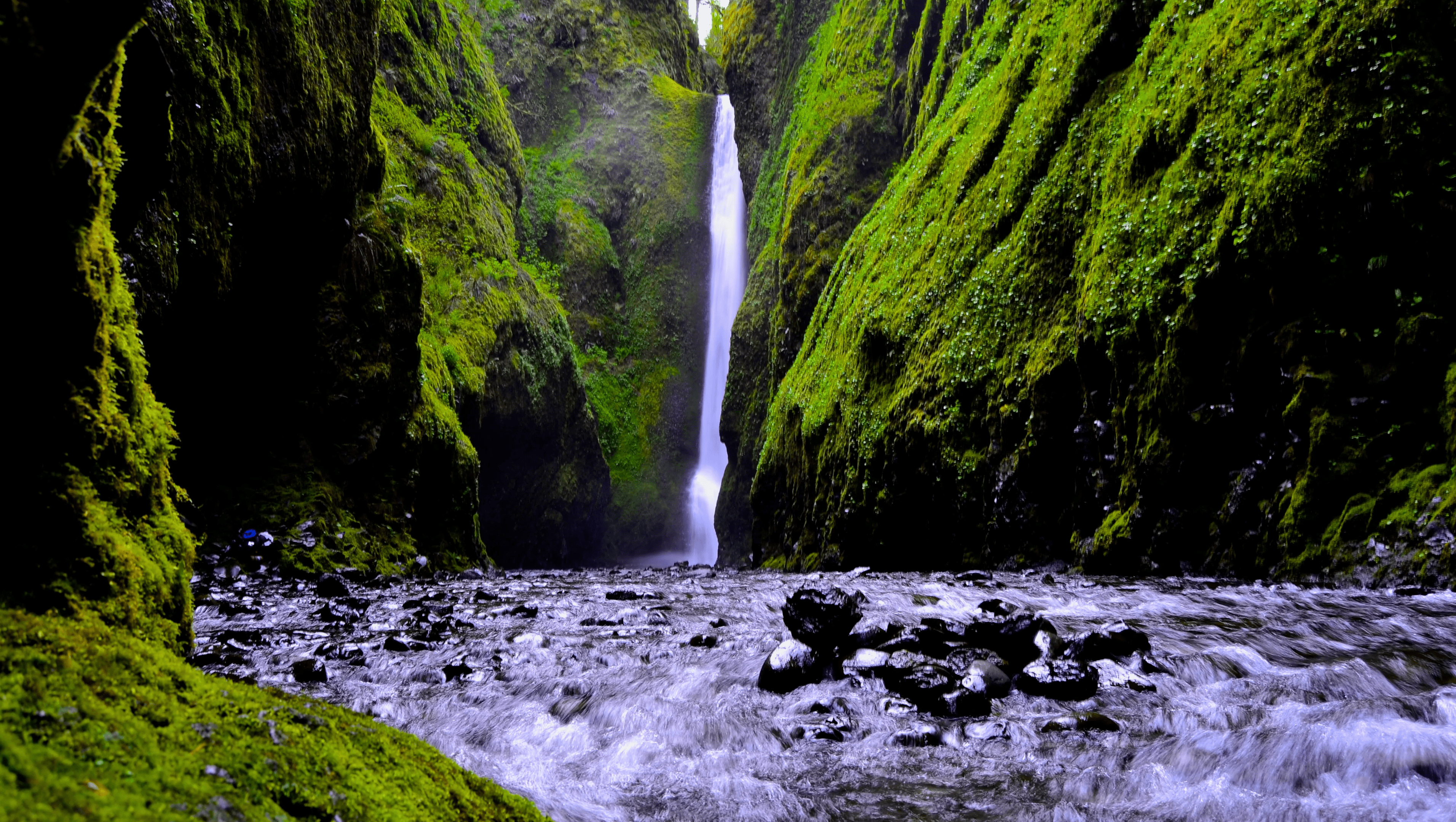
Lower Oneonta Falls
A slot-canyon waterfall reached only by wading through Oneonta Creek.
Closed Indefinitely: Fire Damage and Recent Fatality
Lower Oneonta Falls has been off-limits since the 2017 Eagle Creek Fire. The route was never maintained. It’s a creek-bed wade through a slot canyon, and a hiker died here in March 2024. The U.S. Forest Service marks the area closed and Oregon State Parks does not recommend attempting it under any conditions.
Lower Oneonta Falls is the famous slot-canyon waterfall: a 100-foot ribbon at the dead end of a narrow basalt corridor reached only by wading up Oneonta Creek through a massive logjam. It was a bucket-list adventure for years, and it became the site of repeated injuries, search-and-rescue calls, and a fatality in March 2024.
The 2017 Eagle Creek Fire destabilized the canyon walls, and the Forest Service has consistently advised against entering. Even before the fire, the route required wading through chest-deep water, navigating a logjam that has shifted unpredictably, and accepting hypothermia risks year-round.
For Oneonta scenery without the danger, the Oneonta Trail #424 is open. The 5.7-mile out-and-back climbs to Triple Falls and crosses Middle Oneonta Falls on a metal bridge. The canyon view from above is just as photogenic and far safer.
Sweet Creek Falls
Eleven cascades along a single creek-side trail near the Oregon Coast.
Sweet Creek is one of the best easy waterfall hikes in the entire state. Eleven distinct waterfalls and cascades line a 2.2-mile out-and-back trail along Sweet Creek in the Coast Range east of Mapleton, with nearly continuous water-on-water photography opportunities. Steel catwalks bolted to the rock walls let the trail follow narrow ledges directly above the creek.
The largest fall, Sweet Creek Falls itself, drops about 70 feet at the trail’s end. Side trails from other trailheads (Beaver Creek, Wagon Road, Homestead) add more falls and longer loops. The whole drainage stays cool and damp; you’ll see ferns and mosses on every surface.
No permits, no fees, leashed dogs welcome. The drive in from Mapleton is paved and family-friendly. Best flow is November through April; late summer thins it considerably.

Henline Falls
A 125-foot waterfall and an old silver mine in the Opal Creek Wilderness.
Closed by Forest Order for Fire Recovery
Henline Falls Trailhead and the entire Little North Santiam corridor remain closed under USFS Forest Order through May 2026 due to the 2020 Beachie Creek Fire. Forest Service Roads 2207 and 2209 are damaged. Some portions of Opal Creek may begin reopening in 2026; full restoration is more likely in 2027.
Henline Falls is a slim 125-foot plunge in the heart of Opal Creek Wilderness, with a unique companion: the Silver King Mine, a hand-cut shaft running approximately 1,500 feet straight back into the cliff face beside the falls. Until the 2020 Beachie Creek Fire, the 1.8-mile round-trip trail was a beginner-friendly favorite with a gentle grade, mossy old-growth, and mining history at the destination.
The fire changed the entire Opal Creek drainage. Jawbone Flats was largely destroyed. Forest Service roads collapsed. The closure has now stretched five years. As of late 2025, the Forest Service indicated some areas of Opal Creek may begin to open in 2026, but Henline Falls Trailhead specifically remains under Forest Order through at least May 2026.
Check the Willamette National Forest alerts page before any planning. Closure orders extend regularly.
Moon Falls
A 125-foot ribbon and a half-mile walk to a near-empty trailhead in the Umpqua.
Moon Falls is the closest thing to a private waterfall in Oregon. The half-mile out-and-back trail starts at a small unmarked pullout deep in the Umpqua National Forest east of Cottage Grove, descends through old-growth Douglas-fir, and ends at the base of a 125-foot horsetail ribbon falling over moss-covered basalt. Most days you’ll have the place to yourself.
The trade-off is the drive. Forest Service roads to the trailhead are unpaved, sometimes potholed, and not maintained for low-clearance vehicles. Cell service vanishes well before the parking area. Bring an offline map and a vehicle with reasonable ground clearance.
No fees or permits. Leashed dogs welcome. Best flow is December through May; by August the ribbon thins to a trickle.
Spirit Falls
A bulbous moss-covered cliff and a 60-foot veil: the most photogenic short hike in the southern Willamette.
No Swimming or Camping, Municipal Watershed
Spirit Falls sits in the Layng Creek Municipal Watershed, the drinking-water source for the city of Cottage Grove. Swimming, wading, and camping are all prohibited within the watershed. Pack out every scrap and stay on the trail.
Spirit Falls is the cinematic centerpiece of the Cottage Grove Ranger District’s waterfall trinity (with neighboring Moon Falls and Pinard Falls). Alex Creek glides over a smooth bedrock step, then slips 60 feet down a bulbous, moss-covered basalt cliff carved by the snowmelt of countless winters. The shape is unique in Oregon: most plunge falls drop straight, while Spirit pours around the rock, creating a veil that looks almost like fabric.
The official trail is just 0.3 miles each way, a short woodland descent with switchbacks at the end through old-growth Douglas-fir, western hemlock, western red-cedar, and big-leaf maple. The whole loop is under a mile and the elevation gain is mild. A Boy Scout troop built the trail in the early 1980s, after part-time USFS employee Kevin Riel discovered the falls in 1978 and originally named them Andrea Falls (after his wife). The Oregon Board of Geographic Names later changed it to honor the Boy Scouts.
Best flow is April through June. By late summer the falls thin to a lacy cascade. Combine with Moon Falls (3.2 miles up the road) and Pinard Falls (a few miles farther) for a full day of waterfall hiking from a single drive, totaling about 3 miles of hiking spread across three trails. Note: this is the Umpqua’s Spirit Falls, not the famous 33-foot kayaking drop of the same name on Washington’s Little White Salmon River.
Munson Creek Falls
The tallest waterfall in Oregon’s Coast Range. It drops 319 feet over moss-covered cliffs.
Trail Closed Partway Since the 1990s
A landslide in the mid-1990s destroyed the upper portion of the Munson Creek Falls Trail. The accessible trail now ends at a viewpoint partway up the canyon. The Forest Service truncated the route at the best remaining vista point. Do not pass the closure barrier.
Munson Creek Falls is the tallest waterfall in Oregon’s Coast Range, dropping 319 feet over multiple tiers of moss-covered basalt seven miles south of Tillamook. It’s also the tallest waterfall west of the Willamette River, and one of fewer than a dozen Oregon waterfalls confirmed to exceed 300 feet.
The trail to the falls is just a quarter mile each way and threads through one of the best remaining patches of coastal old-growth: Sitka spruce, western red cedar, and one of the tallest known Sitka spruces in the world (260 feet) all stand within the 94-acre state natural site.
The original viewpoint at the base was lost to a landslide in the mid-1990s, and the trail now ends at a railing overlooking the falls from partway up the canyon. The Forest Service describes the new viewpoint as actually offering a better composition than the old one. No fees, no permits, leashed dogs welcome.
Lemolo Falls
A wide 102-foot drop on the upper North Umpqua River.
Lemolo Falls is one of the bigger drops on the North Umpqua, a wide 102-foot block-style waterfall set deep in old-growth Douglas-fir below Lemolo Lake. The 3.4-mile out-and-back trail descends sharply (about 800 feet) through forest along the river before ending at a viewpoint just upstream from the falls.
It’s not a hike for casual visitors. The elevation comes back to bite on the way out, and footing along the river bank can be muddy or rooty in places. But the payoff is a near-private view of one of the most powerful waterfalls in the upper Umpqua drainage.
$5 day-use fee or NW Forest Pass required at the trailhead. Lemolo Lake Resort is the closest base for an overnight visit and offers cabin rentals, a small store, and the access road to several other waterfalls in the area, including Warm Springs and Whitehorse falls.
Paulina Falls
An 80-foot twin waterfall over volcanic cliffs in Newberry National Volcanic Monument.
Paulina Falls is a twin cascade tumbling 80 feet over a volcanic cliff in Newberry National Volcanic Monument, southeast of Bend. The drainage flows out of Paulina Lake, one of two crater lakes inside the Newberry caldera, and the falls themselves split around a basalt rib, forming the characteristic side-by-side double drop.
An upper viewpoint sits 100 feet from the parking lot. A 0.5-mile spur descends to a lower viewpoint at the base of the falls; another short trail leads to Paulina Lake itself. Total combined distance for a full visit is well under a mile, but elevation on the lower trail is steep enough that hiking poles help on the return.
Newberry NVM Day Pass ($5) or interagency pass required. The road to Paulina Lake closes in winter, typically early November through Memorial Day weekend. Combine with East Lake, Big Obsidian Flow, or Paulina Peak for a full day in the caldera.
McDowell Creek Falls
A loop trail past three named waterfalls in a small county park east of Lebanon.
McDowell Creek Falls County Park is a small Linn County park east of Lebanon that punches well above its weight: 1.6 miles of loop trails connect three named waterfalls: Royal Terrace Falls (119 feet, four tiers), Majestic Falls (39 feet, viewed from a wooden deck), and Crystal Pool Falls (a small but photogenic pool drop).
The trails are maintained, well-graded, and family-friendly. A wooden viewing platform at Majestic Falls is wheelchair-accessible from one of the parking lots. Bigleaf maple, vine maple, and red alder line the canyon, and fall colors here are reliably excellent in mid-October.
No fees, no permits, leashed dogs welcome. Restrooms at the trailheads. The park is open daily from 7 AM to sunset and rarely crowded outside summer weekends.
At a Glance
All 24 waterfalls, ranked and compared
| No. | Waterfall | Region | Height | Distance | Difficulty | Status |
|---|---|---|---|---|---|---|
| 01 | Multnomah Falls | Columbia Gorge | 620 ft | 2.4 mi | Easy | Permit |
| 02 | Silver Falls | Willamette Valley | 177 ft (S. Falls) | 7.2 mi | Moderate | Open |
| 03 | Proxy Falls | Central Oregon | 226 ft | 1.6 mi | Easy | Permit |
| 04 | Wahclella Falls | Columbia Gorge | 350 ft (USFS) | 1.8 mi | Easy | Closed |
| 05 | Tamolitch Falls (Blue Pool) | Central Oregon | 60 ft | 4.2 mi | Moderate | Caution |
| 06 | Toketee Falls | Southern Oregon | 113 ft | 0.8 mi | Easy | Caution |
| 07 | Abiqua Falls | Willamette Valley | 92 ft | 0.7 mi | Difficult | Caution |
| 08 | Sahalie & Koosah Falls | Central Oregon | 100 / 70 ft | 2.6 mi | Easy | Open |
| 09 | Latourell Falls | Columbia Gorge | 224 ft | 2.4 mi | Moderate | Open |
| 10 | Tamanawas Falls | Mt Hood | 100 ft | 4 mi | Moderate | Detour |
| 11 | Punchbowl Falls | Columbia Gorge | 33 ft | 3.8 mi | Moderate | Closed |
| 12 | Drift Creek Falls | Oregon Coast | 75 ft | 3 mi | Easy | Open |
| 13 | Elowah Falls | Columbia Gorge | 213 ft | 1.4 mi | Moderate | Open |
| 14 | Marion Falls | Willamette Valley | 120 ft | 5.4 mi | Moderate | Permit |
| 15 | Salt Creek Falls | Central Oregon | 286 ft | 0.6 mi | Easy | Open |
| 16 | Lower Oneonta Falls | Columbia Gorge | 100 ft | 0.8 mi | Difficult | Closed |
| 17 | Sweet Creek Falls | Oregon Coast | 70 ft | 2.2 mi | Easy | Open |
| 18 | Henline Falls | Willamette Valley | 125 ft | 1.8 mi | Easy | Closed |
| 19 | Moon Falls | Willamette Valley | 125 ft | 0.5 mi | Easy | Open |
| 20 | Spirit Falls | Willamette Valley | 60 ft | 0.6 mi | Easy | Caution |
| 21 | Munson Creek Falls | Oregon Coast | 319 ft | 0.5 mi | Easy | Caution |
| 22 | Lemolo Falls | Southern Oregon | 102 ft | 3.4 mi | Moderate | Open |
| 23 | Paulina Falls | Central Oregon | 80 ft | 0.25 mi | Easy | Open |
| 24 | McDowell Creek Falls | Willamette Valley | 119 ft (Royal Terrace) | 1.6 mi | Easy | Open |
Interactive Map
All 24 waterfalls plotted across Oregon
What to Pack
Five essentials for Oregon waterfall hikes
01
Waterproof Boots
Oregon waterfalls live in mossy, wet, slippery basalt environments. Boots with aggressive lugs and waterproof membranes (Gore-Tex or equivalent) are non-negotiable. Trail runners work in summer; for the rest of the year, boots win.
Browse footwear →02
Rain Shell
You will get wet. Either from spray, mist, or one of Oregon’s signature surprise showers. A packable shell with pit zips solves the perpetual sweating-vs-soaked tradeoff most non-locals run into.
Browse rain gear →03
Hydration
A 2L reservoir or two 24-oz bottles cover most day hikes on this list. For longer routes (Trail of Ten Falls, Eagle Creek when reopened), bring a filter; Oregon’s creeks run clear and cold but should still be treated.
Browse hydration →04
Microspikes (Winter)
Several falls on this list freeze partially in winter (Multnomah, Tamanawas, Latourell), and the spray creates thick black ice across the trail. Microspikes turn an unsafe scramble into a solid-footing walk.
Browse safety gear →05
ND Filter + Tripod
The silky-smooth waterfall photos in this guide require a long shutter speed, which requires a neutral-density filter and a stable platform. A 6-stop ND and a lightweight travel tripod fit most camera kits without bulking up your pack.
Browse photography gear →Common Questions
Everything we get asked about Oregon waterfall hikes
What is the tallest waterfall in Oregon?
Multnomah Falls is Oregon’s tallest waterfall at 620 feet: a 542-foot upper tier, a 9-foot connecting cascade, and a 69-foot lower tier. The U.S. Forest Service credits it as the second-tallest year-round waterfall in the United States, although the World Waterfall Database disputes that ranking.
When is the best time to visit Oregon waterfalls?
Late March through early June delivers peak flow on most waterfalls in this guide. Snowmelt and spring rain combine to drive maximum volume right when wildflowers start to bloom. Late summer (August and September) thins many falls to a trickle. Fall brings color but reduced flow. Winter offers ice formations and solitude, bring traction.
Which Oregon waterfalls are currently closed?
As of April 2026, five waterfalls on this list are fully closed or have major access issues: Wahclella Falls, Punchbowl Falls (Eagle Creek Trail), Tamanawas Falls main trail (detour available), Lower Oneonta Falls, and Henline Falls. The first three are due to December 2025 storm damage. Lower Oneonta has been closed since the 2017 Eagle Creek Fire. Henline has been closed since the 2020 Beachie Creek Fire. See each individual entry for the full status and any detours.
Do I need a permit for Multnomah Falls?
Yes, between May 22 and September 7, 2026. A $2 timed-use permit is required to park in the I-84 Exit 31 lot between 9 AM and 6 PM. Reserve up to 14 days ahead on Recreation.gov. The permit is not required outside that window, and is not required if you arrive by bike, on foot, or via the Columbia Gorge Express bus from Portland’s Gateway Transit Center.
Are dogs allowed on Oregon waterfall trails?
Dogs on leash are allowed on most trails in this guide. Two notable exceptions: the Canyon Trail at Silver Falls State Park does not allow dogs, and Lower Oneonta Falls (currently closed) is not appropriate for dogs even when access returns. Cliff exposure is a concern on Eagle Creek and Latourell, keep leashes short.
Can I swim at Oregon waterfalls?
It varies. Some pools historically saw swimmers, including Punchbowl Falls (when reopened) and Drift Creek. Others are dangerous regardless of how inviting they look: Tamolitch (Blue Pool) is 37 to 42°F year-round and has caused multiple fatalities. Multnomah Falls prohibits swimming entirely. Cliff diving is illegal at Punchbowl and elsewhere. When in doubt, look at the water and don’t get in.
Which waterfall hike is best for kids?
Munson Creek Falls (0.5 mi, paved approach), Drift Creek Falls (3 mi with a fun suspension bridge), Sahalie & Koosah (wheelchair-accessible viewpoints), Sweet Creek (level boardwalk along eleven cascades), and McDowell Creek Falls (1.6 mi with three named falls and a wheelchair-accessible viewing platform at Majestic Falls) are all good calls for families with young kids.
What pass do I need for Forest Service trailheads?
The Northwest Forest Pass ($30 annual or $5 day-use) is the most common requirement and covers most U.S. Forest Service trailheads in Oregon. The America the Beautiful interagency pass ($80) also works at all Forest Service sites. State park trailheads (Silver Falls, Latourell, Munson Creek) use a separate Oregon State Parks pass or charge a per-day fee at the gate.
Continue Exploring
More guides for your next Oregon adventure
~
Get out there.
Oregon’s waterfalls are at their best when you arrive early, stay a while, and respect the closures. Tag @oregon_tails if you make it out, we love seeing where people end up.
