Elowah Falls Trail: 213-Foot Waterfall in the Columbia River Gorge
A 1.4-mile round-trip hike to one of the most dramatic plunge waterfalls in the Columbia River Gorge, 45 minutes east of Portland via I-84. One of the best easy waterfall hikes near Portland with no permit required. Optional extension adds a cliff catwalk and a second waterfall. No fee. No permit. Dogs welcome.
Trail Stats
The geology behind the falls

Unlike Multnomah Falls and Eagle Creek, Elowah Falls has no timed-entry permit, no day-use fee, and no reservation system. Just drive up and hike.
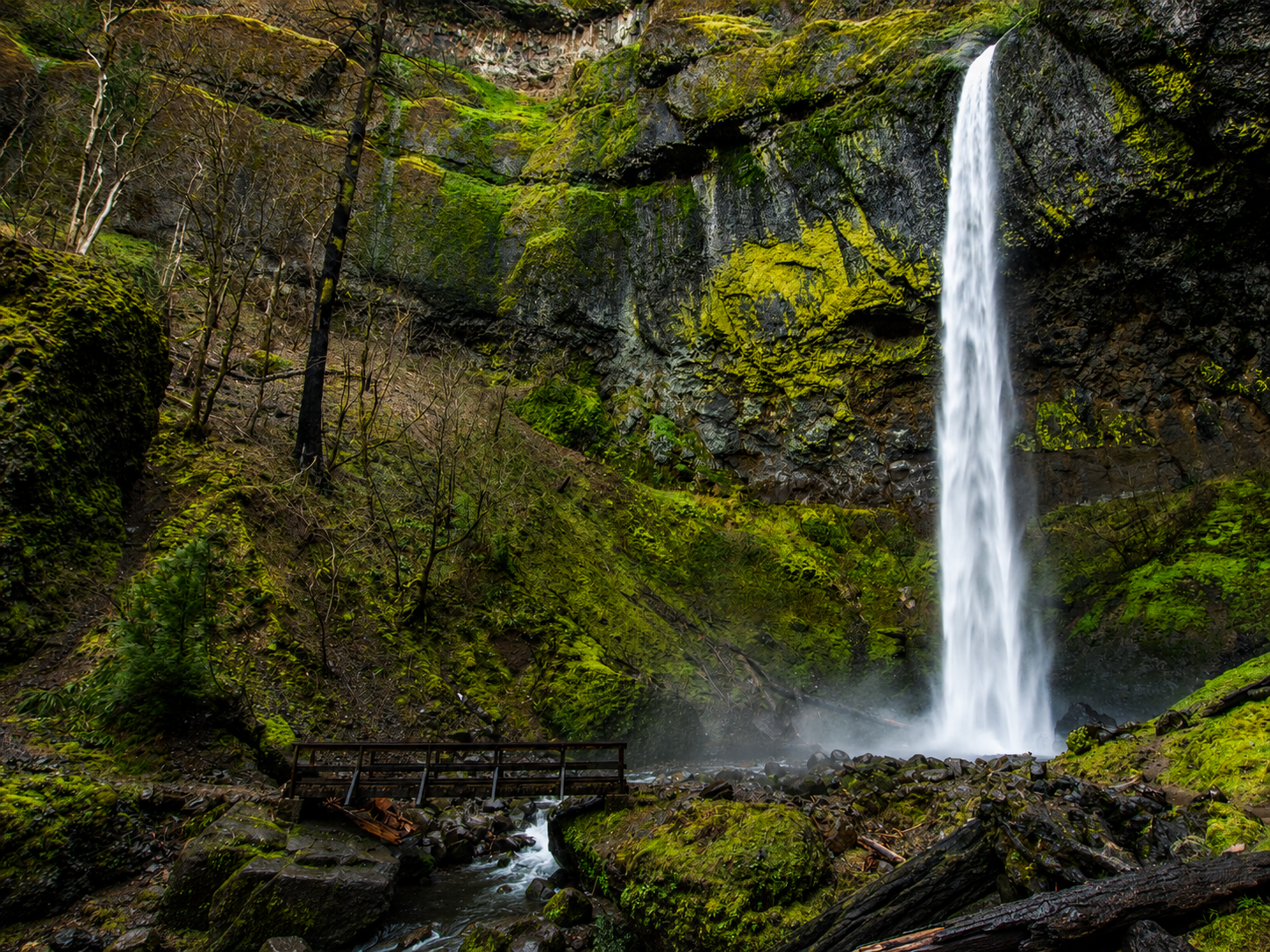
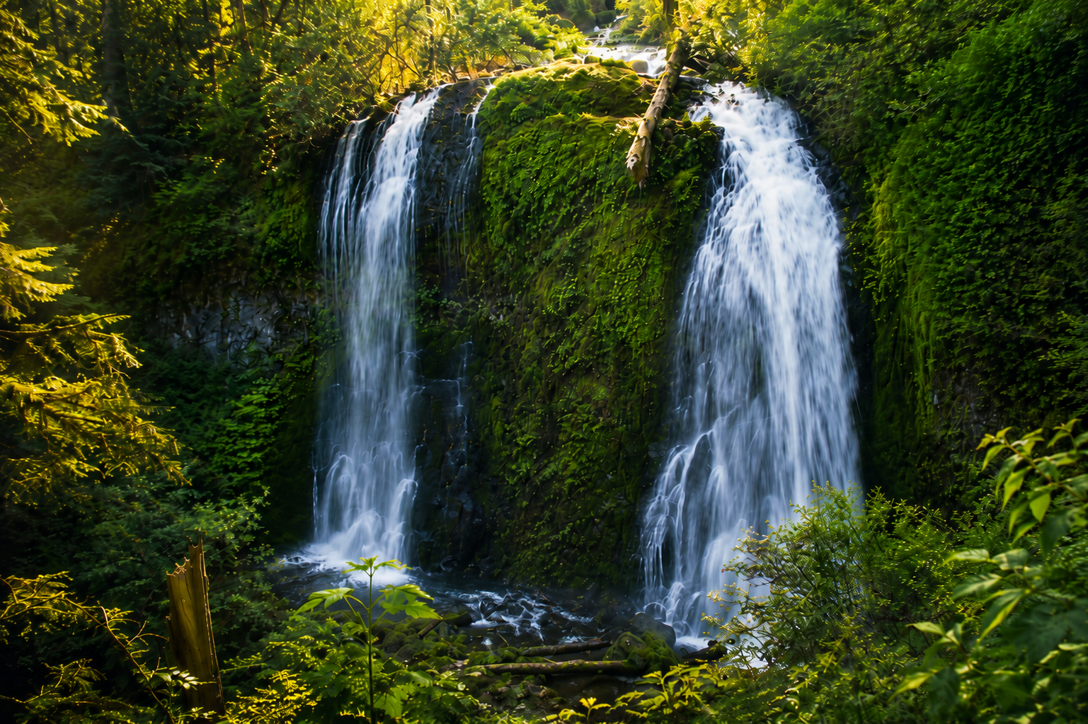
Elowah Falls drops 213 feet in a single free-fall plunge, what geologists call a plunge waterfall, where the water clears the cliff face entirely on the way down. The pool at the base is deep enough that the impact kicks up a persistent mist cloud that drifts several hundred feet into the surrounding canyon. On still mornings in spring, that mist hangs in the old-growth Douglas fir canopy above the viewpoint, creating one of the most atmospheric photographs in the entire Gorge.
The waterfall exists because of the Columbia River Basalt, a series of massive lava flows that poured out of eastern Oregon and Washington between 15 and 17 million years ago. The flows reached what is now the Pacific Coast and buried the landscape under hundreds of feet of basalt. When the Columbia River re-established its course after the flows, it cut the canyon we now call the Columbia River Gorge, slicing through all those layers. McCord Creek, which feeds Elowah Falls, drains a tributary canyon cutting perpendicular through those same basalt layers. The columnar basalt formations visible at the rim of the falls are textbook examples of how this rock fractures as it cools.
The name Elowah comes from Chinook jargon, roughly meaning “high” or referencing a high rocky place: an apt name for a waterfall that drops off a basalt cliff. The trail is within the Columbia River Gorge National Scenic Area, managed by the U.S. Forest Service, but the trailhead access point is a John B. Yeon State Natural Area parking lot, managed by Oregon State Parks.
Getting to Elowah Falls: directions & parking
Address/directions: From Portland, take I-84 east to Exit 35 (Bonneville), about 35 miles from downtown. At the bottom of the ramp, turn left (east) and continue on the Frontage Road for approximately 1.8 miles. The John B. Yeon State Natural Area parking lot is a small gravel pullout on the left (north) side of the road. There is a trailhead sign at the parking area.
Parking: The lot holds approximately 8 to 10 cars. It fills by 9am on summer weekends. Arrive before 8am on weekends from May through September, or plan a weekday visit. There is no overflow parking nearby and roadside parking on the Frontage Road is not officially sanctioned. Arriving at sunrise during peak season eliminates the parking headache entirely.
No fee, no pass required. Unlike many Columbia Gorge trailheads, the John B. Yeon lot does not require a Northwest Forest Pass or an Oregon State Parks day-use permit at the time of writing. This is one of the few significant Gorge waterfall hikes with zero cost to access, a significant difference from the timed-entry permit system now in place at Multnomah Falls. Verify current requirements at Oregon State Parks before your visit.
Trail walkthrough, mile by mile
Both Elowah Falls and Upper McCord Creek Falls start from the same trailhead. The trail splits at about 0.5 miles, with the left fork going to the base of Elowah Falls and the right fork climbing to the Upper McCord Creek Falls cliff catwalk. (Current conditions and user reviews are tracked on AllTrails.) Here is what to expect on each stretch:
Trailhead to forest
From the parking area, the trail immediately enters second-growth Douglas fir and bigleaf maple forest, following McCord Creek upstream through the canyon. The path is well-maintained with a gentle to moderate grade. The creek is audible but not always visible through the trees. Spring wildflowers (trillium, bleeding heart, oxalis) line the trail from mid-March through May. The first stretch is shaded and relatively easy; the biggest exertion comes after the fork.
The signed fork
At approximately 0.5 miles, a signed junction marks the split between the two destinations. A signpost indicates left for Elowah Falls (lower trail, descending) and right for Upper McCord Creek Falls (upper trail, climbing). If you’re doing both, the most common approach is to go left first: descend to the base of Elowah Falls, return to the fork, then climb to the upper falls. The lower Elowah trail is easier on tired legs as a first objective.

Footbridge and the base of Elowah Falls
The left fork descends to McCord Creek and reaches a footbridge just downstream of the falls’ impact pool. From the bridge, the full 213-foot plunge is visible: the water launches off the basalt rim and free-falls in a near-vertical curtain before exploding into the rock pool below. The mist extends 100 to 200 feet in wet season; a rain jacket or changing into a second layer helps here. Stay on the established viewpoint area; the rock is slippery and the pool deeper than it looks. This is the turnaround point for the lower-only hike.
Best time to visit Elowah Falls
| Season | What to expect | Verdict |
|---|---|---|
| Spring (Mar-May) | Maximum water volume, wildflowers lining the trail, bigleaf maples leafing out. Trail can be muddy after rain. Mist at the base is heavy. | |
| Summer (Jun-Aug) | Water flow lower but still impressive. Dry trail, warm approach. Crowds and parking pressure peak Jun-Aug weekends. Best light is early morning. | |
| Fall (Sep-Nov) | Lower crowds after Labor Day. Bigleaf maple and vine maple add golden-orange color to the canyon. Water volume begins to recover with October rains. | |
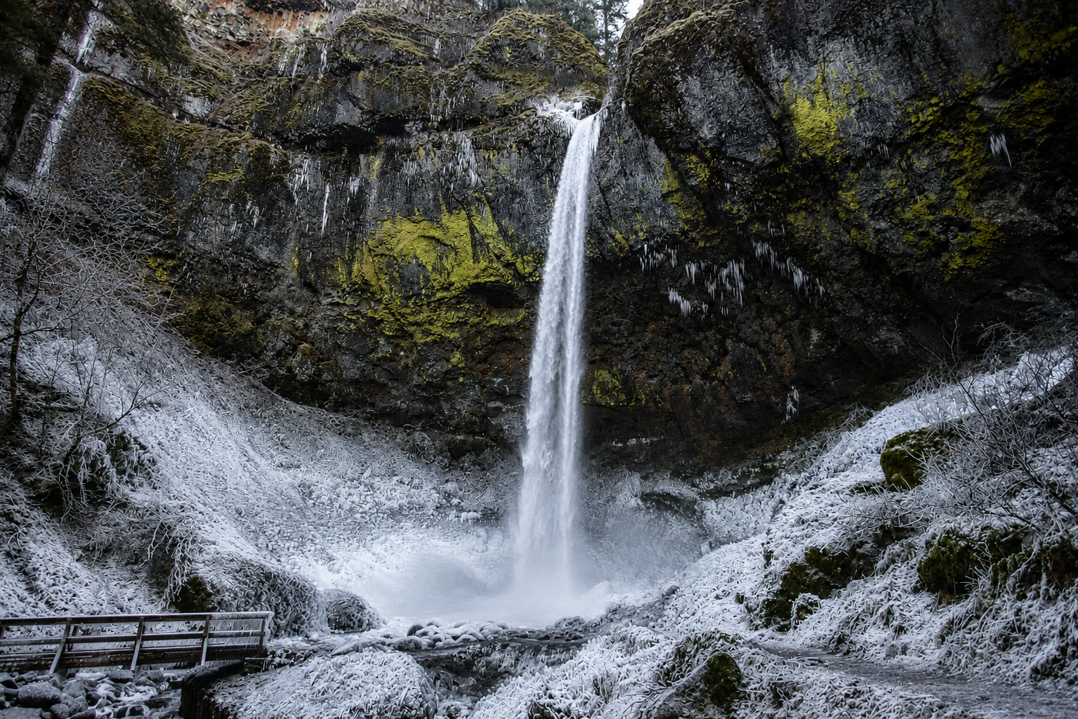
| Winter (Dec-Feb) | Trail can be icy, especially on the cliff catwalk. Water volume high when it’s not frozen. Fewest crowds. Cold. Check conditions first. |
The sweet spot is late April through June for the most powerful waterfall, or September and October for the best photography light and fall color. Avoid any weekend between July 4 and Labor Day before 10am without arriving at sunrise.
Trail conditions & hazards
The Elowah Falls trail is typically open year-round but can be affected by ice, landslide debris, and storm damage. Check Oregon State Parks or the USFS Columbia River Gorge NSA office for current conditions before any winter or early spring visit.
- Icy trail in winter. The cliff catwalk section of the Upper McCord Creek Falls trail becomes very slippery when frozen. Metal microspikes are recommended for any visit from December through February. Do not attempt the upper trail in icy conditions without traction.
- Slippery rock at the falls base. The footbridge viewpoint area is wet year-round from mist. The rock surfaces around the base of the falls are coated in wet algae and are extremely slippery. Stay on the designated viewing area and do not approach the pool edge.
- Parking lot fills fast. In summer, the lot fills by 9am on weekends. Plan to arrive before 8am or go on a weekday.
- No cell service. The Frontage Road and trail have no reliable cell coverage. Download offline maps via Gaia GPS or AllTrails before you leave the highway.
- 2017 Eagle Creek Fire recovery. The Eagle Creek Fire burned significant areas of the eastern Columbia River Gorge in 2017. The Elowah Falls area is at the western end of the affected zone near Bonneville (Exit 35). The trail has been fully repaired and open. Some standing dead trees remain on the ridgelines above the canyon.
- Poison oak. Present along the lower creek corridor, particularly in fall when the leaves turn red. Stay on trail and wear long pants if you’re sensitive.
Upper McCord Creek Falls extension
The extension to Upper McCord Creek Falls is one of the most distinctive trail experiences in the Columbia River Gorge, and it is criminally underrated compared to Elowah Falls itself. Do not skip it if you have the time and the legs.
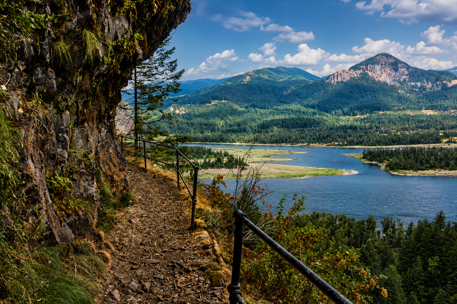
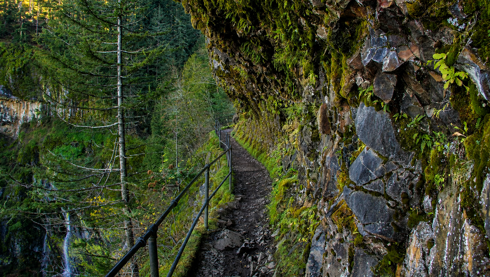
From the fork at 0.5 miles, the right branch climbs steadily through forest via switchbacks before reaching the cliff catwalk: a narrow trail section built into the basalt cliff face, with metal railings on the exposed side. The catwalk traverses the cliff for about 300 yards, with big views east down the Columbia River and back west toward Bonneville Dam. If you are uncomfortable with narrow trails and significant drop-offs, turn around here. For everyone else, this is the highlight of the entire hike.
At the end of the catwalk, the trail descends slightly into the upper canyon and reaches Upper McCord Creek Falls, approximately 100 feet tall, dropping into a narrow slot in the basalt. Because this trail sees far fewer visitors than the lower Elowah Falls, the upper canyon feels genuinely isolated despite being just over a mile from a major interstate. The total round-trip for the upper trail only is 2.2 miles; combined with the lower trail, plan for about 3 miles total.
The upper trail adds about 200 extra feet of elevation gain beyond the lower trail. In dry summer conditions, the upper trail is drier underfoot than the mist-drenched base of Elowah. In winter, the exposed cliff catwalk is significantly more dangerous than the lower trail; avoid in icy conditions.
Hiking with dogs at Elowah Falls
Dogs are allowed on the Elowah Falls trail on leash. The lower trail to the base of Elowah Falls is suitable for most dogs: moderate grade, manageable footing, and the bridge at the base provides a natural end point. The upper trail with the cliff catwalk is a different story. The narrow path with significant exposure can be distressing for dogs who are reactive to heights or who pull on a leash on exposed terrain. The metal railings are not high enough to prevent a fall if a dog lunges sideways. If your dog is pull-prone or anxious in exposed spots, skip the catwalk section or leave them on a very short leash.
- Bring extra water: the creek is not safe to drink without filtering, and mist from the falls is not a reliable water source
- Keep leash short on the catwalk: the drop on the exposed side is real
- Check paws after the hike: the basalt trail surface can be abrasive on pads over longer distances
- High summer afternoons in the Gorge reach 90°F+: the forest trail is shaded but the parking area is hot; plan the hike before noon
Photographer’s notes: shooting Elowah Falls
- Best light: mid-morning in spring. The falls face roughly north, so direct light doesn’t reach the bowl until mid-morning when the sun is high enough to clear the canyon rim. Overcast days actually produce better results than sunny days because they eliminate the harsh contrast between shadow in the bowl and bright mist.
- Use a slow shutter for the water. The falls are tall enough that a slow shutter (0.5 to 2 seconds) creates the silky cascade effect without losing structural detail. Use a tripod or stabilize against the bridge railing. Polarizing filter will cut the glare off wet rocks.
- The mist will soak your lens. In spring at peak flow, the mist extends far into the viewing area. Bring a microfiber cloth and keep lens caps on between shots. A lens hood is essential. Consider a weather-sealed camera body in high-flow months.
- Fall color composition. The bigleaf maples along the approach trail turn gold and orange in October. The best compositions combine the maple canopy with the creek in the foreground, particularly in the 0.2-0.4 mile section before the fork.
- The cliff catwalk viewpoint. From the catwalk on the upper trail, a telephoto lens (70-200mm) compresses the Columbia River beautifully with Bonneville Dam visible to the west. Sunrise from the catwalk in fall, with fog over the river, is a genuinely rare Gorge composition that almost no one shoots.
- No drones. Drones are prohibited within the Columbia River Gorge National Scenic Area. All aerial photography requires a special use permit from the USFS.
What to pack for Elowah Falls
- Water bottle or hydration pack: 1.5 liters per person minimum (the creek is not safe to drink without treatment)
- Rain jacket: even on sunny days, the mist at the base of the falls gets you wet; on high-flow spring days, it’s like standing in moderate rain
- Waterproof hiking shoes or boots: the rocks around the falls base and the catwalk when wet require real grip; do not hike in sandals or road running shoes
- Microspikes: mandatory if visiting December through February; see our hiking safety gear guide
- Trekking poles: recommended for the upper catwalk section, especially in wet conditions
- Day pack: keeps both hands free on the catwalk; anything 10-20L is ideal for this hike
- Offline map: download Gaia GPS or AllTrails route before leaving I-84; no cell service at the trailhead
- Headlamp: essential for sunrise departures (recommended in summer to beat the parking crunch)
- Snacks and sunscreen: the approach trail is shaded but the cliff catwalk is fully exposed
- Camera gear: polarizing filter and microfiber cloth are essential: mist from the falls will coat your lens continuously
- Extra layers: the Gorge is famously fickle; the trailhead can be sunny while the canyon floor is 15 degrees cooler and dripping wet
- First aid kit: slippery rocks at the falls base make ankle rolls a real risk; carry an ACE bandage
- Cash/credit: Thunder Island Brewing in Cascade Locks (5 min east) is an excellent post-hike stop; bring payment
Nearby hikes & waterfalls
Elowah Falls is at the western end of the most concentrated waterfall zone in North America. Every exit east on I-84 from Bonneville to Cascade Locks offers another significant waterfall within a short hike. Here are the strongest nearby options:
Multnomah Falls & The Gorge Hub
Bridge of the Gods & Cascade Locks
Frequently asked questions
How long is the Elowah Falls hike?
How tall is Elowah Falls?
Is Elowah Falls free?
Do I need a Northwest Forest Pass for Elowah Falls?
Is the Elowah Falls trail open?
Can you hike Elowah Falls with dogs?
Is Elowah Falls trail family-friendly?
What is the Elowah Falls parking situation?
When is the best time to visit Elowah Falls?
What is Upper McCord Creek Falls?
How long does it take to hike Elowah Falls?
Is the Elowah Falls trail crowded?
Are there restrooms at the Elowah Falls trailhead?
How far is Elowah Falls from Portland?
Last updated May 2026 · Trail status, parking rules, and permit requirements change. Always verify current conditions at Oregon State Parks before your visit.