Best Lakes
in Oregon
From the impossible blue of Crater Lake to remote alpine bowls in the Eagle Cap Wilderness — Oregon’s lakes span every landscape in the state. Here’s the complete guide to finding yours.
Interactive Map — Oregon Lakes
Oregon has more than 1,800 named lakes and reservoirs, spanning every landscape in the state. From the volcanic crater lakes of the Cascades to the glacier-carved waters of the Wallowas, ancient desert playas in the Great Basin to the dune-dammed coastal lakes of the Oregon Coast — few states can match the sheer diversity of what’s on offer here.
This guide maps and ranks 130+ Oregon lakes with filters for fishing, swimming, and camping. Whether you’re chasing trophy brown trout at Paulina Lake, searching for the perfect kayak on Sparks Lake, or planning a family weekend at Detroit Lake, the complete directory below covers every region of the state with the detail you need to plan your trip.
Best Lakes
in Oregon
Eighteen lakes that represent the full range of what Oregon offers — from drive-up family reservoirs to remote wilderness lakes you’ll earn with your boots.

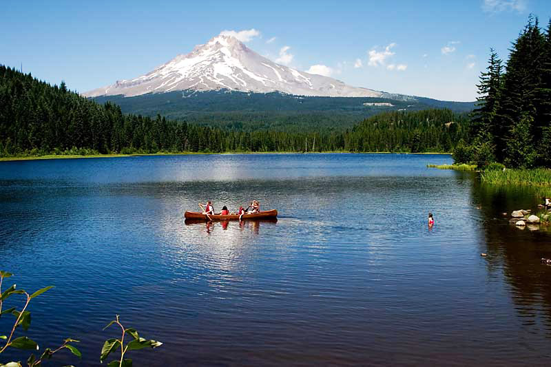
Lake Owyhee

Crater Lake

Paulina Lake

Lost Lake

Mirror Lake

Waldo Lake
Trillium Lake

Pamelia Lake

Diamond Lake

Detroit Lake

Devil’s Lake

Sparks Lake

Wallowa Lake

Clear Lake

Lake of the Woods

Cultus Lake
Suttle Lake

Applegate Lake
All Oregon Lakes
Every lake and reservoir in Oregon. Filter by activity to find what you’re looking for.
| Name ↕ | Region ↕ | Type ↕ | Description ↕ | 🎣 | 🏊 | ⛺ | ⭐ |
|---|---|---|---|---|---|---|---|
| Lake Abert | Eastern Oregon | Alkali | A large, shallow lake in central Lake County | ||||
| Agate Lake | Southern Oregon | Reservoir | An impoundment of Dry Creek | ||||
| Agency Lake | Southern Oregon | Natural | Connected to Upper Klamath Lake | ||||
| Lake Allison | Willamette Valley | Seasonal | Former lake filling the Willamette Valley to a depth of 300–400 feet | ||||
| Alvord Lake | Eastern Oregon | Alkali | A terminus for streams near the Alvord Desert | ||||
| Aneroid Lake | Northeast Oregon | Alpine | In the Eagle Cap Wilderness | ||||
| Antelope Flat Reservoir | Central Oregon | Reservoir | In central Oregon, an impoundment of Bear Creek | ||||
| Antelope Reservoir | Eastern Oregon | Reservoir | Near Jordan Valley | ||||
| Anthony Lakes | Northeast Oregon | Alpine | Also known as North Powder Lakes, in the Elkhorn Mountains | ||||
| ⭐Applegate Lake | Southern Oregon | Reservoir | A flood-control reservoir on the Applegate River | ||||
| Aspen Lake | Southern Oregon | Natural | In the southern Cascade Range, just west of Klamath Falls | ||||
| Baert Lake | Eastern Oregon | Reservoir | An artificial lake in the Christmas Valley | ||||
| Lake Billy Chinook | Central Oregon | Reservoir | An impoundment of the Crooked, Deschutes, and Metolius rivers by Round Butte Dam | ||||
| Big Cliff Reservoir | Cascade Range | Reservoir | A re-regulation reservoir below Detroit Lake | ||||
| Blue Lake | Cascade Range | Natural | Three overlapping craters forming Blue Lake | ||||
| Blue Lake (Fairview) | Columbia Basin | Natural | A recreational lake in Fairview | ||||
| Blue River Reservoir | Cascade Range | Reservoir | An impoundment of the Blue River, a tributary of the McKenzie River | ||||
| Lake Bonneville | Columbia Basin | Reservoir | An impoundment on the Columbia River formed by Bonneville Dam | ||||
| Bonny Lakes | Northeast Oregon | Alpine | Two ponds in the Eagle Cap Wilderness | ||||
| Borax Lake | Eastern Oregon | Alkali | An alkali lake in Harney County, home to the Borax Lake chub | ||||
| Botens Reservoir | Southern Oregon | Reservoir | A small reservoir in the northwestern Klamath Basin | ||||
| Breitenbush Lake | Cascade Range | Natural | Straddles the Cascade crest in the Warm Springs Reservation | ||||
| Buckeye Lake | Southern Oregon | Natural | Near Fish Lake, visible from Grasshopper Mountain | ||||
| Bull Run Lake | Cascade Range | Natural | Portland’s primary drinking water source, northwest of Mount Hood | ||||
| Bully Creek Reservoir | Eastern Oregon | Reservoir | An impoundment of Bully Creek, a tributary of the Malheur River | ||||
| Burnt Lake | Cascade Range | Natural | In the Sandy River watershed | ||||
| Bybee Lake | Columbia Basin | Natural | In the Columbia Slough watershed | ||||
| Cabin Lake | Central Oregon | Seasonal | A small, seasonally dry lake — popular for birdwatching | ||||
| Camp Lake | Central Oregon | Alpine | A small lake at 6,975 ft elevation, northeast of South Sister | ||||
| Lake Celilo | Columbia Basin | Reservoir | Artificial lake created by The Dalles Dam on the Columbia River | ||||
| Christmas Lake | Eastern Oregon | Seasonal | A seasonally dry lake in the Christmas Valley | ||||
| ⭐Clear Lake | Cascade Range | Natural | Spring-fed lake near Sisters — ancient trees visible 40 ft underwater | ||||
| Cleawox Lake | Oregon Coast | Coastal | Dammed by sand dunes along the Oregon Coast near Florence | ||||
| Cooper Creek Reservoir | Southern Oregon | Reservoir | Near Sutherlin in the upper Umpqua River basin | ||||
| Chickahominy Reservoir | Eastern Oregon | Reservoir | An impoundment of Chickahominy Creek near Riley | ||||
| Cottage Grove Reservoir | Willamette Valley | Reservoir | An impoundment of the Coast Fork Willamette River | ||||
| Cougar Reservoir | Cascade Range | Reservoir | An impoundment of the McKenzie River created by Cougar Dam | ||||
| Crane Prairie Reservoir | Central Oregon | Reservoir | A 5.34 sq mi reservoir and one of Oregon’s largest rainbow trout fisheries | ||||
| ⭐Crater Lake | Southern Oregon | Crater | Second deepest in the Western Hemisphere — 1,943 feet of impossible blue | ||||
| Crescent Lake | Southern Oregon | Natural | North of the town of Chemult in Klamath County | ||||
| Cullaby Lake | Oregon Coast | Coastal | A 1.7-mile long north–south lake near Warrenton in Clatsop County | ||||
| ⭐Cultus Lake | Central Oregon | Natural | A mountain lake near the Cascade Lakes Scenic Byway — warm and clear | ||||
| Davis Lake | Cascade Range | Natural | A mountain lake southeast of Oakridge in the Cascade Range | ||||
| Delintment Lake | Eastern Oregon | Natural | Malheur National Forest, Harney County | ||||
| ⭐Detroit Lake | Cascade Range | Reservoir | An impoundment of the Breitenbush and Santiam rivers — Oregon’s summer playground | ||||
| ⭐Devil’s Lake (Lincoln City) | Oregon Coast | Coastal | Source of the D River, one of the world’s shortest rivers | ||||
| Devil’s Lake (Deschutes) | Central Oregon | Natural | A small lake adjacent to the Cascade Lakes Scenic Byway | ||||
| Dexter Reservoir | Willamette Valley | Reservoir | An impoundment of the Middle Fork Willamette River | ||||
| ⭐Diamond Lake | Southern Oregon | Natural | Between Mount Bailey and Mount Thielsen, 10 miles north of Crater Lake | ||||
| Dollar Lake | Northeast Oregon | Alpine | In the Eagle Cap Wilderness | ||||
| Donaca Lake | Cascade Range | Alpine | In the Middle Santiam Wilderness | ||||
| Dorena Reservoir | Willamette Valley | Reservoir | An impoundment of the Row River created by Dorena Dam | ||||
| Doris Lake | Central Oregon | Alpine | A deep, high-elevation lake in Deschutes County | ||||
| East Lake | Central Oregon | Crater | One of two crater lakes at Newberry Volcano | ||||
| Eel Lake | Oregon Coast | Coastal | A large coastal lake near Lakeside in Coos County | ||||
| Elk Lake | Central Oregon | Natural | A small lake along the Cascade Lakes Scenic Byway | ||||
| Emigrant Lake | Southern Oregon | Reservoir | An impoundment of Emigrant Creek in Jackson County | ||||
| Lake Ewauna | Southern Oregon | Natural | Headwaters of the Klamath River | ||||
| Fern Ridge Reservoir | Willamette Valley | Reservoir | An impoundment on the Long Tom River in Lane County | ||||
| Fish Lake (Harney County) | Eastern Oregon | Alpine | In Steens Mountain Wilderness at over 7,300 feet elevation | ||||
| Fish Lake (Jackson County) | Southern Oregon | Reservoir | Formerly a natural lake, now an impoundment of Little Butte Creek | ||||
| Fish Lake (Marion County) | Cascade Range | Alpine | A 20-acre lake in the Cascades near Olallie Lake | ||||
| Flagstaff Lake | Eastern Oregon | Natural | One of the Warner Lakes in southeastern Lake County | ||||
| Floras Lake | Oregon Coast | Coastal | Natural lake behind dunes between Cape Blanco and Bandon | ||||
| Fossil Lake | Eastern Oregon | Seasonal | A seasonally dry lake in northern Lake County | ||||
| Foster Reservoir | Cascade Range | Reservoir | An impoundment on the South Santiam River created by Foster Dam | ||||
| Fourmile Lake | Southern Oregon | Reservoir | An impoundment of Fourmile Creek | ||||
| Gerber Reservoir | Southern Oregon | Reservoir | An impoundment on Miller Creek created by Gerber Dam | ||||
| Goose Lake | Southern Oregon | Natural | In Oregon and California, formerly the headwaters of the Pit River | ||||
| Green Peter Reservoir | Cascade Range | Reservoir | An impoundment of the Middle Santiam River | ||||
| Lake Harriet | Cascade Range | Reservoir | An impoundment of the Oak Grove Fork Clackamas River | ||||
| Harney Lake | Eastern Oregon | Alkali | A natural, occasionally vanishing alkaline lake in Harney County | ||||
| Hells Canyon Reservoir | Northeast Oregon | Reservoir | An impoundment of the Snake River | ||||
| Henry Hagg Lake | Willamette Valley | Reservoir | A 1,200-acre reservoir west of Forest Grove in Washington County | ||||
| Hills Creek Reservoir | Cascade Range | Reservoir | An impoundment of the Middle Fork Willamette River | ||||
| Hosmer Lake | Central Oregon | Natural | A small fly-fishing-only lake off the Cascade Lakes Scenic Byway | ||||
| Howard Prairie Lake | Southern Oregon | Reservoir | A reservoir east of Ashland in Jackson County | ||||
| Hyatt Reservoir | Southern Oregon | Reservoir | An impoundment of Keene Creek southwest of Howard Prairie Lake | ||||
| Island Lake | Southern Oregon | Alpine | An alpine lake in the Sky Lakes Wilderness | ||||
| Jubilee Lake | Northeast Oregon | Reservoir | An impoundment of Motett Creek, popular in the Umatilla National Forest | ||||
| Junipers Reservoir | Eastern Oregon | Reservoir | An artificial lake west of Lakeview | ||||
| ⭐Lake of the Woods | Southern Oregon | Natural | A natural lake west of Upper Klamath Lake with Mt. McLoughlin views | ||||
| Langdon Lake | Northeast Oregon | Reservoir | An impoundment of Morning Creek and source of Lookingglass Creek | ||||
| Lava Lake | Central Oregon | Natural | A small lake along the Cascade Lakes Scenic Byway | ||||
| Legore Lake | Northeast Oregon | Alpine | Highest true lake in Oregon at 8,950 feet, in the Eagle Cap Wilderness | ||||
| Leaburg Reservoir | Willamette Valley | Reservoir | An impoundment of the McKenzie River near Leaburg | ||||
| Lemolo Lake | Southern Oregon | Reservoir | An impoundment of the North Umpqua River about 10 miles north of Diamond Lake | ||||
| Little Crater Lake | Cascade Range | Natural | A tiny spring-fed pool as deep as it is wide, northeast of Timothy Lake | ||||
| Little Cultus Lake | Central Oregon | Natural | A small lake near the Cascade Lakes Scenic Byway | ||||
| Little Lava Lake | Central Oregon | Natural | At the head of the Deschutes River, near the Cascade Lakes Scenic Byway | ||||
| Little Three Creeks Lake | Cascade Range | Natural | A small lake very close to Three Creeks Lake near Sisters | ||||
| Lofton Reservoir | Southern Oregon | Reservoir | An impoundment within the Fremont–Winema National Forest | ||||
| Lookout Point Reservoir | Willamette Valley | Reservoir | An impoundment of the Middle Fork Willamette River | ||||
| Loon Lake | Oregon Coast | Natural | A 216-acre lake in the Coast Range 15.5 miles from Reedsport | ||||
| Lost Creek Lake | Southern Oregon | Reservoir | An impoundment on the Rogue River | ||||
| ⭐Lost Lake | Cascade Range | Natural | Iconic reflection of Mt. Hood — the quintessential Oregon mountain lake | ||||
| Maidu Lake | Southern Oregon | Alpine | Source of the North Umpqua River, in Douglas County | ||||
| Magone Lake | Eastern Oregon | Natural | In the Malheur National Forest north of John Day | ||||
| Malheur Lake | Eastern Oregon | Natural | The terminus of the Donner und Blitzen River and the Silvies River | ||||
| Malheur Reservoir | Eastern Oregon | Reservoir | An irrigation impoundment on Willow Creek (Malheur River) | ||||
| Mann Lake | Eastern Oregon | Natural | The largest playa lake in the north Alvord Valley, Harney County | ||||
| Marion Lake | Cascade Range | Alpine | The largest wilderness lake in Oregon, in the Mount Jefferson Wilderness | ||||
| McGuire Reservoir | Oregon Coast | Reservoir | An impoundment of the Nestucca River | ||||
| McKay Reservoir | Northeast Oregon | Reservoir | An impoundment of McKay Creek, a tributary of the Umatilla River | ||||
| Miller Lake | Southern Oregon | Natural | Natural lake near Pacific Crest Trail west of Chemult | ||||
| Minam Lake | Northeast Oregon | Alpine | Reservoir in Eagle Cap Wilderness; source of Lostine and Minam rivers | ||||
| Mink Lake | Cascade Range | Alpine | Second-largest wilderness lake in Oregon, in Lane County | ||||
| ⭐Mirror Lake | Cascade Range | Natural | A mountain lake southwest of Mount Hood at Tom Dick and Harry Mountain | ||||
| Mirror Pond | Central Oregon | Reservoir | An impoundment of the Deschutes River in central Bend | ||||
| Morgan Lake | Northeast Oregon | Natural | A lake outside La Grande, Union County | ||||
| North Fork Reservoir | Cascade Range | Reservoir | An impoundment of the Clackamas River | ||||
| North Tenmile Lake | Oregon Coast | Coastal | Adjacent to Tenmile Lake near Reedsport | ||||
| Ochoco Reservoir | Central Oregon | Reservoir | A reservoir east of Prineville, Oregon | ||||
| Odell Lake | Southern Oregon | Natural | A mountain lake southeast of Willamette Pass | ||||
| Olallie Lake | Cascade Range | Natural | A mountain lake 10 miles north of Mount Jefferson | ||||
| Oswego Lake | Willamette Valley | Natural | A natural lake (artificially enlarged) — former channel of the Tualatin River | ||||
| ⭐Owyhee Reservoir | Eastern Oregon | Reservoir | Oregon’s longest lake (52 miles), an impoundment of the Owyhee River | ||||
| ⭐Paulina Lake | Central Oregon | Crater | A crater lake inside Newberry Volcano’s caldera at 6,331 feet | ||||
| Perkins Lake | Southern Oregon | Natural | A lake in Douglas County | ||||
| Phillips Lake | Northeast Oregon | Reservoir | An impoundment of the Powder River | ||||
| Pine Hollow Reservoir | Columbia Basin | Reservoir | Impoundments of Threemile and Pine Hollow creeks, two miles NW of Wamic | ||||
| Prineville Reservoir | Central Oregon | Reservoir | An impoundment of the Crooked River in central Crook County | ||||
| Rock Creek Lake | Northeast Oregon | Alpine | Alpine lake on the northern slope of Rock Creek Butte | ||||
| Santiam Lake | Cascade Range | Alpine | Headwaters of the North Santiam River in southwestern Mt. Jefferson Wilderness | ||||
| Siltcoos Lake | Oregon Coast | Coastal | Largest lake dammed by sand dunes along the Oregon coast, near Florence | ||||
| Silver Lake | Eastern Oregon | Seasonal | SE Oregon within the Great Basin | ||||
| Silverton Reservoir | Willamette Valley | Reservoir | An impoundment of Silver Creek | ||||
| ⭐Sparks Lake | Central Oregon | Natural | Shallow reed-fringed mountain lake west of Mt. Bachelor — kayaking perfection | ||||
| Strawberry Lake | Eastern Oregon | Alpine | Biggest lake in the Strawberry Mountain Wilderness near Prairie City | ||||
| Summer Lake | Eastern Oregon | Seasonal | SE Oregon within the Great Basin | ||||
| ⭐Suttle Lake | Cascade Range | Natural | A lake on the east side of Santiam Pass | ||||
| Tahkenitch Lake | Oregon Coast | Coastal | Between Reedsport and Florence, dammed by sand dunes along the Oregon coast | ||||
| Teardrop Pool | Central Oregon | Alpine | Oregon’s highest lake at 10,400 feet — on the summit of South Sister | ||||
| Tenmile Lake | Oregon Coast | Coastal | Largest lake in the Tenmile Creek basin near Reedsport | ||||
| Thief Valley Reservoir | Northeast Oregon | Reservoir | An impoundment on the Powder River | ||||
| Three Creeks Lake | Cascade Range | Natural | A warm lake near Sisters popular for trout fishing | ||||
| Timothy Lake | Cascade Range | Reservoir | An impoundment of the Oak Grove Fork Clackamas River | ||||
| Timpanogas Lake | Cascade Range | Alpine | The headwaters of the Middle Fork Willamette River | ||||
| Todd Lake | Central Oregon | Natural | A small yet popular lake along the Cascade Lakes Scenic Byway | ||||
| Triangle Lake | Willamette Valley | Natural | A small lake 22 miles west of Cheshire | ||||
| ⭐Trillium Lake | Cascade Range | Reservoir | Oregon’s most photographed lake — a perfect Mt. Hood reflection | ||||
| North and South Twin Lakes | Central Oregon | Natural | Two small lakes near the Cascade Lakes Scenic Byway | ||||
| Upper Klamath Lake | Southern Oregon | Natural | Oregon’s largest lake by surface area, fed by the Williamson River | ||||
| Lake Umatilla | Columbia Basin | Reservoir | Impoundment of the Columbia River formed by the John Day Dam | ||||
| Wahtum Lake | Cascade Range | Natural | A small lake on the NNW flank of Mount Hood | ||||
| ⭐Waldo Lake | Cascade Range | Natural | One of the purest lakes in the world — no motors, electric blue, 6,000 feet up | ||||
| Lake Wallula | Columbia Basin | Reservoir | Impoundment of the Columbia River formed by McNary Dam | ||||
| Walton Lake | Central Oregon | Natural | A lake in Ochoco National Forest | ||||
| ⭐Wallowa Lake | Northeast Oregon | Natural | Oregon’s Little Switzerland — glacier-carved beneath Eagle Cap peaks | ||||
| Warm Springs Reservoir | Eastern Oregon | Reservoir | An impoundment of the Malheur River | ||||
| Wickiup Reservoir | Central Oregon | Reservoir | A reservoir south of Mount Bachelor | ||||
| Willow Creek Lake | Columbia Basin | Reservoir | Formed by Willow Creek Dam impounding Willow Creek near Heppner | ||||
| Woahink Lake | Oregon Coast | Coastal | Deepest lake dammed by sand dunes along the Oregon coast, near Florence |
FAQs About Oregon Lakes
Crater Lake is most often called the prettiest lake in Oregon — and it’s hard to argue. Formed 7,700 years ago when Mount Mazama collapsed into itself, it sits at 6,178 feet with water so pure and deep that it produces a shade of blue that doesn’t look real. At 1,943 feet, it’s the deepest lake in the United States and the ninth deepest in the world.
That said, “prettiest” is genuinely contested in Oregon. Waldo Lake is one of the clearest and most pristine lakes on Earth — its water appears electric blue because it contains almost no dissolved minerals. Wallowa Lake in northeast Oregon is glacier-carved beneath peaks that look imported from the Alps. Sparks Lake near Bend frames South Sister and Broken Top in early-morning stillness that stops photographers in their tracks. Oregon simply has too many stunning lakes for any one to win outright.
Oregon has more than 130 named lakes and reservoirs spanning every region of the state. The most significant include:
- Upper Klamath Lake — Oregon’s largest lake by surface area, covering roughly 64,000 acres near the California border
- Crater Lake — the deepest lake in the US at 1,943 feet, and the second deepest in the Western Hemisphere
- Lake Owyhee — Oregon’s longest lake at 52 miles, a remote reservoir in the state’s southeast corner
- Malheur Lake — a vast shallow lake in Harney County, critical habitat within the Malheur National Wildlife Refuge
- Waldo Lake — one of the largest natural lakes in the Cascades and among the purest bodies of water in the world
- Detroit Lake — the most-visited reservoir in Oregon, impounding the Santiam River in the western Cascades
- Lake Billy Chinook — where three rivers meet behind Round Butte Dam, creating dramatic canyon scenery in central Oregon
- Wallowa Lake — the iconic glacier lake of northeast Oregon, flanked by Eagle Cap Wilderness peaks
Yes — and there are actually more than two. Oregon has at least ten lakes named Clear Lake scattered across the state. The two most well-known are quite different from each other:
The most famous is Clear Lake near Sisters in the Deschutes National Forest, a spring-fed pool of extraordinary transparency. The water is so clear that lava-killed trees from a 3,000-year-old eruption are visible standing upright on the lake bottom, up to 40 feet below the surface. No motors are allowed, and the water temperature stays near freezing year-round.
The second commonly visited Clear Lake is near Timothy Lake on the south side of Mount Hood — a seasonal winter rental lookout sits on Clear Lake Butte above it, and the lake itself offers good trout fishing. When searching for a specific Clear Lake in Oregon, always confirm the county or region to make sure you’re headed to the right one.
You actually can swim in Crater Lake — but only at one location, and only when the park’s access trail is open. The sole permitted swimming and water-access point is Cleetwood Cove, reached by a steep 1.1-mile trail (with 700 feet of elevation change) on the north rim. The trail typically opens in late June or July once snow clears, and closes by mid-October.
Swimming is not allowed anywhere else along the caldera rim because the vertical walls drop hundreds of feet straight into the water, making entry and exit from any other point impossible and extremely dangerous. The water temperature at the surface ranges from about 55–60°F in summer — cold, but swimmable. The lake’s extraordinary purity means no sunscreen or soap is permitted in the water.
If you’ve heard that swimming is banned entirely, that may stem from temporary closures due to algae blooms or trail conditions that have occurred in recent years. Always check the Crater Lake National Park website for current access status before your visit.
Trillium Lake, located just a few miles south of Government Camp near Mount Hood, is widely considered Oregon’s most photographed lake. The view from its eastern shore — Mount Hood’s 11,249-foot volcanic cone perfectly mirrored in the still water at dawn — has appeared in countless magazines, travel guides, and photography collections. A paved accessible loop trail circles the lake, making it reachable by nearly everyone, which has only added to its iconic status.
Crater Lake is a strong contender for the title as well, particularly the view from Rim Drive looking across the caldera to Wizard Island. But for a single postcard image that captures Oregon’s landscape in one frame, Trillium Lake’s Mt. Hood reflection is the one that appears most consistently in print and online.
The most well-known “secret beach” in Oregon is Secret Beach (officially part of Samuel H. Boardman State Scenic Corridor) near Brookings in the far south coast. It’s reached by a short but steep trail through old-growth forest that drops down to a sheltered cove framed by sea stacks and tide pools. The trail is unmarked on many maps, which has kept it quieter than Oregon’s more famous beaches. Look for the trailhead near milepost 338.5 on US-101.

Oregon’s 362-mile coast is entirely public land — every beach is legally accessible to the public under the Oregon Beach Bill of 1967. This means many genuinely secluded beaches exist up and down the coast that simply require more effort to reach. Other hidden coastal gems include Whaleshead Beach and China Beach in Boardman, Coquille Point near Bandon, and numerous coves accessible only at low tide between Cape Perpetua and Florence. The reward for the extra hiking is almost always solitude and dramatic scenery.