Welcome to Oregon’s Waterfall Highway, the 172-mile Rogue-Umpqua Scenic Byway that threads together more than a dozen of the Cascades’ most spectacular waterfalls along a single unforgettable drive.
From Roseburg east through the Umpqua National Forest to Diamond Lake, then south along the Upper Rogue toward Crater Lake National Park and Gold Hill, Highway 138 and its sister routes ascend through old-growth forest past crashing rapids and columnar-basalt canyons. The North Umpqua Trail alone runs 79 miles along the river, linking trailheads to many of the falls on this list.
Below, 16 waterfalls worth pulling over for: from roadside cascades you can see without lacing your boots to backcountry plunges that earn their reward. Stats, difficulty, and our honest favorites. For more guides like this, see our roundup of the best waterfall hikes in Oregon and our complete Southern Oregon hikes hub.
The Best Waterfalls of the Waterfall Highway

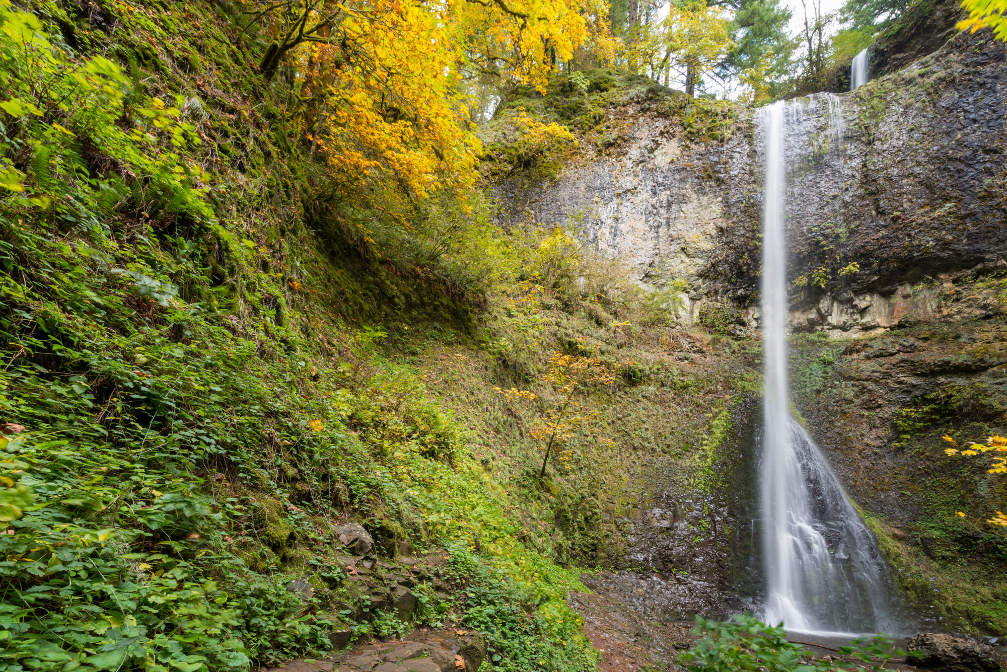
Watson Falls
EasyOften cited as Oregon’s third-tallest waterfall: a 272-foot free-fall into a basalt amphitheater.
Watson Falls is the giant of the Waterfall Highway, and one of the most dramatic short hikes in Southern Oregon. A well-maintained trail climbs through old-growth Douglas-fir and mossy boulders to a viewpoint where the creek hurtles off a cathedral-shaped basalt wall. Only Multnomah Falls and Mist Falls (both in the Columbia Gorge) are typically ranked taller.
Photos don’t quite do it justice. Come in late June or early July when snowmelt is still feeding the flow, and expect to get misted on the upper platform. Steep but short: most visitors reach the lookout in 15–20 minutes.
View on AllTrails
Watson Falls Trail Map

Toketee Falls
ModerateThe poster child of the North Umpqua: a two-tier plunge framed by columnar basalt.
“Toketee” is Chinook Jargon for “graceful,” and the waterfall earns the name. The North Umpqua River slots through a narrow basalt gorge and drops in two stages: a 40-foot upper cascade followed by an 80-foot sheer plunge into a deep emerald pool. It’s the most photographed stop on the entire Waterfall Highway.
The trail involves roughly 200 stairs and some uphill, ending at a wooden viewing platform across the gorge. Flow is unusually consistent year-round because of an upstream diversion dam, so Toketee looks great even in late summer. Don’t skip the leaky 12-foot wooden penstock pipe at the trailhead. It’s worth a photo stop.
View on AllTrails
Toketee Falls Trail Map

Umpqua Hot Springs
EasyNot technically a waterfall, but the geothermal detour you want in the middle of your byway day.
A short but steep hike leads to a series of stair-stepped mineral pools perched on a bluff above the North Umpqua. Each pool sits at a different temperature, so you can pick your soak. Cell service drops long before you get here.
Go early: mornings before 9 a.m. are your best bet for quiet, and the Forest Service requires day-use permits during peak season. A pair of trekking poles helps on the steep descent. If you’re based closer to Portland, our hot springs near Portland guide has other options, but this one remains our favorite in the state.
View on AllTrails
Umpqua Hot Springs Trail Map
Clearwater Falls
EasyA mossy, spring-fed cascade thirty seconds from your car door.
One of the easiest wins on the byway. Clearwater Falls is spring-fed, so the flow barely changes through the year, and the cascade tumbles over moss-covered volcanic rocks into a glassy pool. Perfect stretch-your-legs stop between Toketee and Diamond Lake.
View on AllTrailsThe byway has earned the nickname Highway of Waterfalls. And once you’ve driven the Waterfall Highway end-to-end, you understand why.
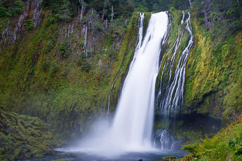
Lemolo Falls
Moderate–HardOur favorite stop on the entire Waterfall Highway. The tallest and most powerful waterfall on the North Umpqua.
“Lemolo” is Chinook Jargon for “wild” or “untamed,” and the falls live up to it. The North Umpqua breaks over a contorted columnar-basalt cliff and plunges 165 feet into a thundering pool. At peak flow the entire cliff face becomes a 60-foot-wide wall of spray.
Logistics note: there’s no cell service at the trailhead. Download your map from AllTrails ahead of time, or in Google Maps, search for “Lemolo Falls Trailhead #2.” The standard upper trailhead gives you a 3-mile hike to an elevated overlook: scenic, but you end up on the opposite side of the falls and the scramble down is steep. Trailhead #2 gets you closer to the base for the classic view.
View on AllTrails
Lemolo Falls Trail Map (Trailhead #2)

Susan Creek Falls
EasyA gentle, family-friendly walk to a moss-draped cascade and a pretty footbridge.
A graded trail with about 187 feet of gain winds through mossy forest to Susan Creek Falls, a gentle, fan-style cascade with great bridge views and picnic spots below. Solid choice when you’ve got kids or tired legs. The trail continues past the falls to the Susan Creek Indian Mounds, a traditional vision-quest site.
View on AllTrails
Susan Creek Falls Trail Map

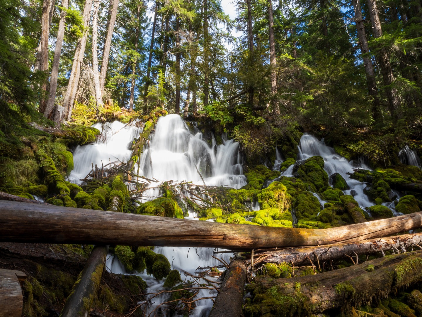
Fall Creek Falls
ModerateFour stacked tiers tumbling through a slot canyon of basalt and moss.
Fall Creek Falls is one of the most accessible falls in the North Umpqua corridor. It descends roughly 120 feet over four tiers (approximately 10, 40, 20, and 50 feet), with the uppermost tier visible only from the top. The trail threads through a dramatic bedrock slot called Jobs Garden, where you squeeze between walls of basalt.
Heads up: portions of this trail were damaged by the 2020 Archie Creek Fire. Check the latest Umpqua National Forest trail status before visiting.
View on AllTrails
Fall Creek Falls Trail Map
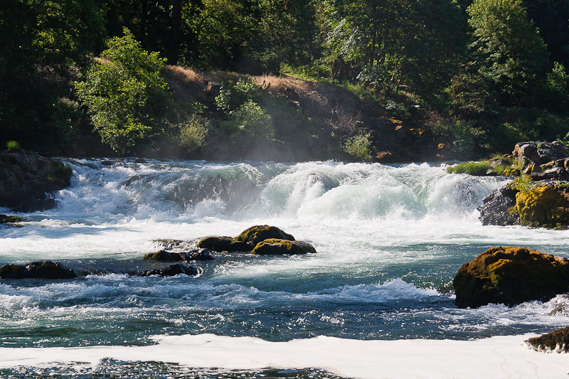
Deadline Falls
EasySmall falls, huge payoff. Watch salmon leap upstream from May through October.
Deadline Falls isn’t about the drop. It’s about what’s jumping up it. From late spring through fall, steelhead and Chinook salmon rocket through the air as they push upstream to spawn. The trailhead is at Swiftwater Park, the western end of the 79-mile North Umpqua Trail, and the walk is short enough that anyone can do it.
Best viewing is early morning when the light is soft and the fish are active. Bring a polarizing filter if you’re shooting the river.

Wolf Creek Falls
EasyA two-tier cascade at the end of a gentle forest walk along Wolf Creek.
Wolf Creek Falls punches well above its trail rating. The path follows the creek through lush second-growth forest, crosses footbridges, and ends at a surprisingly tall cascade that drops in two distinct stages into a quiet pool. Great rating on AllTrails (4.7 stars) and rightfully so: low effort, high reward.
View on AllTrails
Wolf Creek Falls Trail Map

Grotto Falls
EasyWalk behind a curtain of water through a moss-covered amphitheater.
Grotto Falls is a short detour off the Little River Road, and the approach alone is worth it: moss-draped firs, fern-filled undergrowth, the whole Pacific Northwest cliché in one photogenic package. A recessed alcove behind the falls means you can actually walk behind the water curtain. Small parking area, so arrive early on weekends.
View on AllTrails
Grotto Falls Trail Map

Whitehorse Falls
EasyA perfect roadside plunge into a turquoise pool, the easiest stop on the byway.
A small but picture-perfect plunge into an absurdly blue pool, visible from the Whitehorse Falls Campground day-use area. Park, walk 30 feet, photograph. That’s the whole trip, but tucked between longer hikes on the Waterfall Highway, it’s a satisfying little stop and makes an easy picnic spot.

Steamboat Falls
EasyA wide block waterfall with cliff-jumping rock slabs and steelhead runs.
Steamboat Creek sheets over a wide basalt ledge into a tranquil pool, impressive in winter and spring when the drainage is pumping, noticeably tamer by May. There’s a fish ladder beside the falls that diverts flow, but it also means you can watch steelhead launch themselves up-channel during spawning runs (May–July).
The flat rock slabs around the falls are popular for sunbathing and cliff-jumping in summer, one of several reasons it makes our best Oregon swimming holes list. Heads up: all fishing is closed on Steamboat Creek and its tributaries to protect North Umpqua steelhead spawning habitat.
View on AllTrails
Steamboat Falls Trail Map

Shadow Falls
ModerateAn optical illusion carved into bedrock: water seems to pour through a hole that isn’t there.
Shadow Falls lives on Cavitt Creek, tucked away from the main byway in a quieter corner of the Umpqua National Forest. The creek has carved a slot gorge full of potholes and a tight chasm where the water appears (from certain angles) to be pouring through a hole in solid rock. It’s a trick of perspective, but a cool one.
View on AllTrails
Shadow Falls Trail Map

Yakso Falls
EasyA veiling fan-shape waterfall that shifts appearance with every step you take.
Yakso is the largest waterfall on the Little River, and what makes it special is the cliff shape: rounded basalt “knobs” bulge outward from the face, splitting the water into multiple veils within the overall fan. The waterfall looks completely different from left, center, and right; worth walking around the viewing area rather than snapping one photo and leaving.
View on AllTrails
Hemlock Falls
ModerateA horsetail cascade down a rugged, fallen-tree-strewn gorge, backed by lush ferns and moss.
Hemlock Creek winds down a chasm of mossy boulders, ferns, and fallen old-growth trunks before launching off a 45-foot drop. The surrounding gorge is almost as photogenic as the falls themselves; the understory feels prehistoric. The trail starts from Lake-in-the-Woods campground, a high-country lake with an unexpectedly manmade origin story.
View on AllTrails
National Creek Falls
ModerateA spring-fed twin cascade tumbling into a green, moss-carpeted grotto, with year-round flow.
National Creek Falls is quietly one of the most photogenic falls in the entire region. The spring-fed creek splits around a basalt outcrop and drops in two scenic channels into a lush grotto draped in moss. Just downstream, a flat meadow of emerald moss marks where Falls Creek meets National Creek.
Because it’s spring-fed, the flow stays consistent all year, making this a rare shoulder-season win when most Oregon waterfalls are half-empty.
Basecamp for Waterfall Hunting
Our pick for a Waterfall Highway basecamp is Umpqua’s Last Resort. They offer glamping tents (with power and fans), full RV hookups, cabins, and a range of lodging options for different budgets. Staff are genuinely friendly, and there’s a convenience store within walking distance for anything you forgot to pack. Book early in summer; weekends fill fast.
Want to camp instead? See our roundup of the best camping spots in Oregon. For something completely different, you can also stay in an Oregon fire lookout; a few are close enough for a byway side trip.
More Oregon Adventures


The End of the Road
Sixteen waterfalls, one two-lane highway, and enough mist, moss, and basalt to fill a week of hiking. From roadside plunges to backcountry cascades, Oregon’s Waterfall Highway is the most concentrated waterfall drive in the state, and arguably the country. Pack layers, download maps, and give yourself more time than you think you need.