Hiking Abiqua Falls, Oregon
A short out-and-back through Mt. Angel Abbey forest to a 92 foot columnar basalt amphitheater waterfall, hidden behind a rough road, an unmarked turn, and a rope descent that earns the view.
Trail Stats
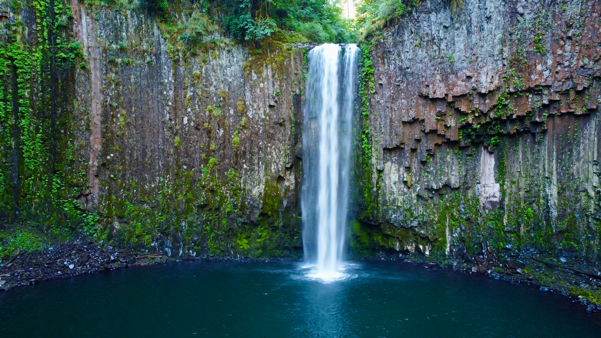
Abiqua Falls is the kind of place that turns regulars into evangelists. A 92 foot ribbon of water pouring down a curved basalt cliff, into a green pool, with a quiet pebble beach across the creek that gives you the best photo angle in the Willamette Valley. The trail to it is short. The road is the part that filters the crowd.
The hike itself runs 0.8 to 1.4 miles round trip depending on whether you stop at the base of the falls or scramble out to the photo spot across the creek, with about 315 feet of elevation loss to the water. Most people finish it in 1 to 1.5 hours including time at the falls. The catch is the last 4 to 5 miles of Crooked Finger Road, which is rough enough that the right vehicle and the right weather window matter more than your fitness.
Hexagonal basalt and a 16-million-year-old amphitheater
Abiqua Falls plunges off the same Columbia River Basalt that built nearby Silver Falls State Park. Those flows roared through this part of Oregon between 16 and 6 million years ago and cooled into the dark, columnar basalt that now ribs the cliff face. Look up from the pool and you will see hexagonal columns stacked like organ pipes, the same jointing pattern that makes Iceland’s Svartifoss famous. Abiqua Creek has been carving back the cliff face ever since, scooping it into the half-bowl that gives the falls their amphitheater shape.
The creek itself originates near Lookout Mountain, runs roughly 29 miles to its confluence with Pudding Creek, and is Silverton’s main source of drinking water. It runs through the historical territory of the Molala and Kalapuyan peoples; the name “Abiqua” is of Indigenous origin, though its source language and meaning remain uncertain. Linguist Henry Zenk’s research on Kalapuyan placenames notes that no Kalapuyan name for the creek has been preserved in the historical record. The pool at the base stays cold year-round, and the cliff above is a textbook example of how cooling lava cracks into geometric columns when you take a minute to look up.
Getting there & parking
Abiqua Falls sits in the Cascade foothills east of Salem, Oregon, on private land owned by the Abbey Foundation of Oregon (the nonprofit arm of Mt. Angel Abbey). The drive from downtown Salem runs about 45 minutes if Crooked Finger Road is dry, longer if it isn’t. Public transit is not an option. Cell signal drops out before you get there, so download offline maps in town.
Drive times to the trailhead
Driving and trail route from Crooked Finger Road to Abiqua Falls
Driving directions
From Salem to the Abiqua Falls trailhead
- From Salem, head north on Highway 213 (Silverton Road NE) for about 14 miles into Silverton.
- Continue north on 213 toward Mt. Angel, then turn east on Mt. Angel-Scotts Mills Road for about 2 miles into Scotts Mills.
- From Scotts Mills, take Crooked Finger Road NE south for roughly 9 miles. The pavement ends and the road becomes rough gravel.
- Continue about a mile on gravel, then turn right onto an unnamed forest road (CF300) and follow it past the Crooked Finger OHV staging area.
- The road dead-ends at a locked Abbey Foundation gate. Park along the shoulder. The trailhead opening is on the left, about 40 yards before the gate.
Parking note: The Google-marked parking area is real, but it is not the trail. Parking there adds 2 to 3 miles of road walking each way, with a steep climb on the return. The unofficial dirt shoulder at the locked gate fits maybe 6 to 10 vehicles. On a sunny weekend it fills by mid-morning. Arrive early or come on a weekday.
GPS coordinates: 44.93099°N, 122.56757°W. Trailhead opening is roughly 40 yards before the gate, on the left side of the road.
Restrooms: None at the trailhead, the parking shoulder, or the falls. The last public restroom is the gas station in Scotts Mills, about 9 miles back.
Last gas: Scotts Mills (limited hours) or the Chevron in Silverton, 20 minutes back.
Trail walkthrough, mile by mile
The trail is short but it covers more terrain than the distance suggests. Here is what each section actually feels like under your boots.
Finding the trailhead
The trail entrance is not at the gate itself. About 40 yards before the gate, on the left side of the road, look for a bootworn path dropping into the trees. There is no formal sign at the exact opening, but foot traffic has worn it obvious if you know to look. Lock its position into your memory: there is no marker on the way out, and tired hikers regularly miss the exit on the return. The first stretch is gentle, soft underfoot, and downhill. You can hear the creek before you see it.
Past the Abbey Foundation sign
A pair of signs nailed to a tree confirms you are on the right track and on private land. The Abbey allows public access at your own risk under Oregon recreational use law. Keep heading downhill on the main path. After a few minutes you will hit a fork with a downed tree on the right hand side. Stay left. The right fork leads to an unprotected cliff edge above the falls with no viewpoint and no descent route. Every season someone has to be talked back from it.
The rope-assisted descent
The trail drops sharply through a section of slick clay and exposed roots. Knotted ropes are strung between trees on the steepest parts to assist with the descent. Use them. The clay turns to soup after rain, and the rope is the difference between a clean descent and a muddy slide. Bring a cheap pair of gardening gloves. Veterans of this hike never skip them. The rope is rough enough to burn ungloved palms, and gloves give you actual grip on the muddy stretches. Take your time and plan your foot placement. Coming back up is harder than going down.
Creek crossing and the falls
At the bottom of the ropes you arrive at Abiqua Creek. Turn left along the creek and rock-hop or wade about 50 yards. The cliff face appears in front of you, curved like a half-bowl, and the falls drop into the pool. The pebble beach across the creek is the photographer’s spot. The base of the falls is colder than it looks and the rocks underfoot are slick with spray.
Best time to visit
The falls are open year-round, but the road and the rope section make this trail genuinely seasonal. The wrong week can turn a one-hour hike into a four-hour adventure or a turnaround.
| Season | Months | Conditions | Verdict |
|---|---|---|---|
| Spring | Apr – May | Strong flow, some mud on the rope section, wildflowers in the surrounding forest. Sunny weekends fill the lot. | |
| Summer | Jun – Aug | Reliable road conditions and warm-enough water for a quick wade. Flow drops as the season goes on. Crowds peak on weekends. | |
| Fall | Sep – Oct | Light crowds, gold and rust forest color, reasonable road conditions through mid-October. Our quiet-day favorite. | |
| Winter | Nov – Mar | The road gets rutted and muddy. Rope section turns to slick clay. Possible to do, but only with the right vehicle and clear weather window. |
If you want both the strongest flow and a passable road, target a clear week in late April or May. Photographers should aim for a fully overcast day to flatten the contrast, and arrive within an hour of when sun would be hitting the cliff face directly to keep the basalt out of harsh shadow.
The road, the ropes, the rules
Three real hazards: the road, the ropes, and isolation.
The last 4 to 5 miles of Crooked Finger Road have potholes deep enough to crack an oil pan and ruts that swallow standard sedans. Reports of broken axles and damaged undercarriages on this road are not uncommon. AAA does not run out here, and there is no cell signal to call them. A 4×4 or high-clearance SUV is the right tool. After heavy rain, even the right vehicle can get stuck.
The rope-assisted descent is the only way to the creek. The ropes are volunteer-installed and not maintained by anyone. Inspect them before you commit, plant your feet, and never trust a rope as your only point of contact. After rain, the clay underneath turns to slip-and-slide.
This is private land with a “use at your own risk” sign for a reason. There is no ranger, no patrol, no signal. Tell someone where you are going and when you will be back. Do not assume someone else will come along.
Can you swim at the pool?
The plunge pool at the base of Abiqua Falls is cold, rocky, and not really set up for swimming. People wade in regularly on warm summer afternoons and stand under the spray, but the bottom is uneven rock and the water stays cold year-round because it is fed by snowmelt and shaded by the cliff for most of the day.
If a longer soak is the goal, head south to one of the deeper holes along Abiqua Creek where it widens, or back to a developed swimming hole on the Molalla River. The pool here is about the falls, not about the swim. Wade in for the photo, get out before your toes go numb.
Hiking with dogs

Dogs are allowed on the trail and we have seen plenty of them at the falls. The catch is the rope descent. A fit medium or large dog can usually scramble it on their own with a hand on the leash, but small breeds and senior dogs will need to be lifted. Bring a longer leash for the rope section and a shorter one for the creek crossing where loose rocks shift underfoot.
At the falls, treat the basin like a slick rock kitchen floor. Spray makes everything greasy. Keep the leash short, keep your dog out of the deepest pool, and rinse paws afterward. The basalt has sharp edges that can nick pads.
Photographer’s notes
Abiqua Falls is one of the most photographed waterfalls in Oregon, and the conditions that make it sing are not the ones most visitors plan around. A few things we have learned over multiple trips.
- Overcast beats sunny. Direct sun on the cliff blows out the basalt highlights and throws the falls into hard shadow. A flat overcast day evens the contrast and saturates the moss greens. Light rain is even better for color, just protect your gear.
- Shoot from the pebble beach across the creek. The classic angle is the rocky bench on the far side of Abiqua Creek, framed by the curved basalt amphitheater. Wading across is required and the rocks underfoot are slick.
- Go wide. The amphitheater is too tight for a telephoto. A 16 to 24mm full-frame equivalent captures the cliff curve and the falls together. Phones with ultrawide lenses do well here.
- Use a polarizer and an ND for long exposure. One to two seconds gives you the silky-water effect without losing all texture in the falls. The polarizer cuts the spray glare on the wet rocks and pulls more color out of the moss.
- Drone with restraint. The Abbey has not posted a no-drone rule, but this is private land. Be quiet, fly low, finish in five minutes, and never fly over other visitors. Don’t make this the trip the Abbey decides to close access.
What to pack for Abiqua Falls
This is a short hike with a couple of pieces of gear that genuinely earn their spot. Treat the rope and the creek as the two design constraints.
Nearby trails & waterfalls
If you have driven all the way out to Scotts Mills, it is worth stacking another waterfall on the same trip. Two Willamette Valley favorites are within a reasonable drive.
Frequently asked questions
How long is the trail to Abiqua Falls?
Who owns Abiqua Falls?
Do you need a 4×4 or SUV for Abiqua Falls?
Where do you park for Abiqua Falls?
How tall is Abiqua Falls?
Is Abiqua Falls dog friendly?
Can you swim at Abiqua Falls?
How hard is the Abiqua Falls hike?
Is there cell service at Abiqua Falls?
When is the best time of year to visit Abiqua Falls?
Is Abiqua Falls worth the hike?
What is the road to Abiqua Falls like?
Are there bathrooms at Abiqua Falls?
Can you fly a drone at Abiqua Falls?
Last updated: May 2026 · Trail conditions, road conditions, and access policies can change. The land is privately owned by the Abbey Foundation of Oregon. Check current conditions before you go.