Koosah & Sahalie Falls Trail
A 2.6-mile loop along the McKenzie River with two of Oregon’s most photogenic waterfalls, an accessible viewing deck, and a starring role in a 1993 Disney movie.
Trail Stats
📍 Sahalie Falls coordinates: 44.34896, -121.99686 · Elevation: ~3,300 ft · Add up to 0.3 mi of spurs for top-of-falls and west-bank overlooks.
Koosah & Sahalie Falls are the kind of waterfall hike where you can do as much or as little as you have time for. The Sahalie observation deck is a few hundred feet from the parking lot on a paved path, fully accessible, and one of the loudest, mistiest viewpoints in Oregon. From there, the Waterfalls Loop Trail strings together two waterfalls, a stretch of old-growth forest, and a McKenzie River footbridge into an easy 2.6-mile loop.
The trailhead sits along Highway 126 in the central Cascades – officially the McKenzie Pass-Santiam Pass National Scenic Byway – about an hour from Eugene and an hour and fifteen from Bend. Both falls have their own parking areas, both are free, and dogs are welcome on leash. Koosah Falls sits on the lower lava bench and tends to be the quieter of the two stops; Sahalie Falls is the louder, mistier upstream view and gets most of the parking-lot crowd. If the name Sahalie sounds familiar, you may have seen the falls in the 1993 Disney film Homeward Bound: The Incredible Journey, where the river-rescue scene was shot on this exact stretch of the McKenzie.
Trail map
The AllTrails widget below shows the full Waterfalls Loop route, with both viewpoints and the Carmen Reservoir footbridge crossing.
Waterfalls Loop Trail · 2.6 mi loop · interactive map by AllTrails
The geology & names behind the falls
How two lava flows built a pair of waterfalls
About 3,000 years ago, two thick flows of basaltic andesite lava poured down off the High Cascade volcanoes and dammed the McKenzie River canyon, which created Clear Lake several miles upstream. The river found two outlets through the lava barrier on its way south, and that’s why you get two waterfalls instead of one. Sahalie Falls drops first over a steep lava dam, then continues another 40 feet of foaming whitewater. Half a mile downstream, Koosah Falls pours over a second lava lip into a deep emerald pool. The whole stretch is essentially a fossil record of a slow-motion volcanic event told in moving water.
What “Sahalie” and “Koosah” mean
The names come from Chinook Jargon, the rudimentary trade language that let the Kalapuya, Molalla, Sahaptin, and Chinook peoples exchange news and goods across the region. Sahalie roughly translates to “high,” “heaven,” or “sky.” Koosah means “sky” or, in some accounts, “shining.” The names fit: Sahalie is the upper falls, Koosah catches the afternoon light off its emerald pool. Long before the Disney cameras arrived, this corridor was a travel route for tribes heading to the high Cascades for obsidian or huckleberry harvests. Interpretive signs at the Sahalie Falls trailhead tell more of that story.
Getting there & parking
The Sahalie Falls Viewpoint and the larger Koosah / Waterfalls Loop Trail lot are both off Highway 126, between the Highway 20 junction (toward Sisters) and McKenzie Bridge. Approach from the east is faster from Bend; approach from the west is faster from Salem and Portland.
Sahalie Falls Viewpoint · Highway 126 · Willamette National Forest
Driving directions
From Salem (~ 92 mi · 1h 45m)
- Take OR-22 E / Santiam Hwy east about 72 miles toward Detroit Lake.
- Continue east on OR-22 to the junction with US-20 W; turn right (3.1 mi).
- Turn left onto OR-126 E.
- Follow OR-126 about 5 miles to the Sahalie Falls Viewpoint turnoff (or continue to the Koosah / Waterfalls Loop lot).
Driving directions
From Portland (~ 136 mi · 2h 25m)
- Follow I-5 S to OR-22 E / Santiam Hwy toward Salem (~ 43 miles).
- Take exit 253 (Detroit Lk / Bend), follow signs onto OR-22 E.
- Continue east on OR-22 roughly 79 miles to the US-20 junction.
- Turn right toward US-20 W, then left onto OR-126 E.
- Continue 5 miles on OR-126 to the Sahalie Falls Viewpoint on the right.
Parking note: There are two lots off Highway 126, both well-signed. The Sahalie Falls Viewpoint lot is closer to the most-photographed viewpoint and fills first on summer weekends. The Koosah Falls / Waterfalls Loop lot a few hundred yards south is bigger and usually has space – look for the Ice Cap Campground / Koosah Falls sign on the highway. Day use hours are 6 a.m. – 10 p.m. If both lots are full, do not park along the shoulder of Highway 126. Traffic moves fast and the shoulder is narrow, especially in winter.
Official site: Conditions, alerts, and seasonal closures live on the Willamette National Forest’s Sahalie & Koosah Falls page – worth a quick check before you drive out.
Camping nearby: The Ice Cap, Trail Bridge, and Olallie Forest Service campgrounds all sit within a few miles of the trailhead and book up fast on summer weekends. See our guide to the best camping spots in Oregon for reservation tips.
Koosah vs. Sahalie at a glance
The two falls are barely a half-mile apart but feel completely different. Sahalie is the louder, mistier, more dramatic of the two and gets most of the parking-lot crowd. Koosah is quieter, deeper, and the better stop if you want a few minutes alone with the river.
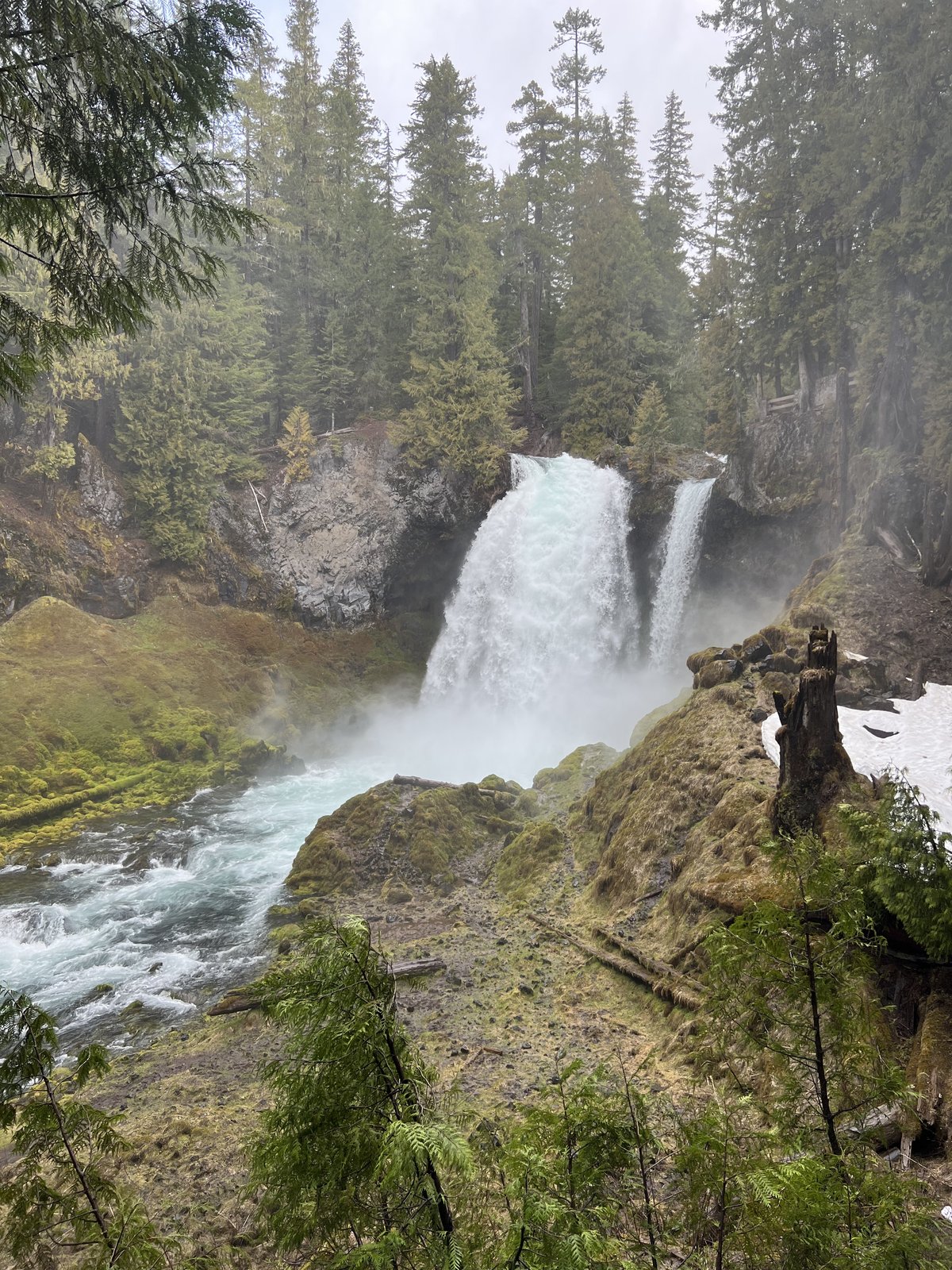
The signature shot. Sahalie plunges over a steep lava dam in a single curtain, then continues another 40 feet of foaming cascade. The observation deck is a short paved walk from the lot, with viewing rails right at the edge of the spray.
Wider, deeper, and quieter. Koosah pours over a second lava lip into an emerald pool that catches afternoon light. The viewpoint is a short walk from the Koosah / Waterfalls Loop lot and is rarely as crowded as Sahalie.
Trail walkthrough, the loop
The published distance is 2.6 miles; you’ll see anywhere from 2.5 to 2.9 depending on which spurs you take to the top-of-falls viewpoints and the west-bank overlooks. Both falls are linked by a short footbridge crossing at Carmen Reservoir, and the trail is well-graded and easy to follow in either direction. Most hikers go counter-clockwise from the Sahalie deck so the loudest viewpoint comes first.
Wooden boardwalk and observation deck
From the Sahalie Falls Viewpoint lot, follow the paved path a few hundred feet to the wooden observation deck. This is the wheelchair- and stroller-friendly part of the trail, and the view is the same one most postcards use. Expect spray on damp days; tuck the camera lens in your jacket between shots.
Old-growth forest along the McKenzie
From the Sahalie deck, follow the trail downstream (south) along the east bank. The path threads through Douglas fir and western hemlock with the river roaring on your right. Roots and small rock steps appear as you descend toward Koosah, and dogs handle this section easily on leash.
Koosah Falls and the emerald pool
The Koosah viewpoint sits about three-quarters of a mile from Sahalie. The falls drop into a pool deep enough to glow green when the sun hits it, and the railing keeps you a safe distance from the edge. From here, continue downstream toward the Carmen Reservoir footbridge or backtrack to your car.
Cross at Carmen and return on the west bank
Cross the McKenzie at the Carmen Reservoir footbridge, climb gently, then turn north along the west bank. The west side is quieter, often empty even on busy weekends, with new-angle views of both Koosah and Sahalie through the trees. A second footbridge above Sahalie returns you to the parking area.
Want to extend? The McKenzie River Trail continues another 1.5 miles north from Carmen Reservoir to Clear Lake, the spring-fed lake the original lava flow created when it dammed this canyon 3,000 years ago. Easy add-on if you have time.
Best time to visit
The falls run year-round, but everything around them changes with the seasons: how the water photographs, how the parking holds up, how comfortable the trail is in shoes versus boots.
| Season | Months | Conditions | Verdict |
|---|---|---|---|
| Spring | Mar – May | Snowmelt brings peak flow. Falls are at their loudest, mist is heavy, parking still wide open. Trail can be muddy near the river. Pairs well with a stop on the way back through the Willamette Valley wildflower bloom. | |
| Summer | Jun – Aug | Long daylight, lush forest, flow tapers slightly. Lots fill before mid-morning. Best to arrive early or visit on a weekday. | |
| Fall | Sep – Oct | Lighter crowds, gold and rust forest color, cooler hiking temps. Our favorite season for the loop. | |
| Winter | Nov – Feb | Highway 126 sees snow and ice. Trail is open but slick near the spray zone. Drive only if you have winter tires. |
If you’re optimizing for photos, May and June pair the highest water with long daylight hours. October trades color for solitude and is just as photogenic in a quieter way.
Accessibility & family notes
The Sahalie deck is one of Oregon’s most accessible big-waterfall views.
The paved path from the Sahalie Falls Viewpoint parking area to the wooden observation deck is short, fairly level, and friendly for wheelchairs and strollers. Accessible restrooms are available at the lot. The full 2.6-mile loop beyond the deck is not paved, but the deck alone is worth the stop if mobility is a factor.
For families with small kids, the boardwalk and railed deck make this a low-stress first viewpoint. Save the loop trail for older kids who can stay on-trail near the river edges, and keep an eye on younger ones at viewpoints without rails.
Hiking with dogs
Dogs are welcome on the Waterfalls Loop Trail on leash. The trail surface is forest duff and small rocks, easy on most dogs’ paws, and the McKenzie offers shaded riverside walking the whole way. The Sahalie deck has a railed perimeter, which makes it a safer viewpoint with excited pups than the open-edge spots near Koosah.
Bring water and a collapsible bowl. The river runs cold enough that a curious dog will drink, but the current is too fast for safe wading. Pack out waste bags, especially near the deck.
What to pack for the loop
It’s a short hike, but you’re standing in waterfall mist for a chunk of it and the weather here flips fast. The basics:
Nearby trails to combine
The McKenzie River corridor is one of the most concentrated stretches of waterfall and hot-spring access in Oregon. If you’ve driven all the way out here, it’s worth stacking a second stop on the same day.
More photos from the McKenzie corridor


Frequently asked questions
How long is the Koosah & Sahalie Falls hike?
What do “Sahalie” and “Koosah” mean?
Are dogs allowed on the Sahalie Falls trail?
Do you need a permit for Koosah & Sahalie Falls?
How tall are Koosah and Sahalie Falls?
Is the Sahalie Falls viewpoint wheelchair accessible?
What’s the best time of year to visit?
Were the falls in Homeward Bound?
Where do you park for the Koosah & Sahalie Falls trail?
How do you get to Sahalie Falls from Sisters or Bend?
Can you swim at Koosah or Sahalie Falls?
Last updated: May 2026 · Trail conditions and access policies can change. Verify with the Willamette National Forest before you go.