
The Painted Hills: One of Oregon’s 7 Wonders
A 33-million-year-old layered landscape in Eastern Oregon’s high desert, 9 miles northwest of Mitchell. Five short trails cover the most photographed unit of John Day Fossil Beds National Monument. Free entry, year-round access, and the most colorful hour is the last hour before sunset.
Painted Hills Quick Stats
The Painted Hills are one of the Seven Wonders of Oregon, and one of the most photographed natural landscapes in the Pacific Northwest. The colored mounds, painted in bands of red, gold, black, and lavender, are not really painted at all: each color is a different mineral concentration in volcanic ash soils that piled up between roughly 33 and 40 million years ago. Erosion has cut down through those ancient soils, exposing the layered colors as striped hillsides.
The Painted Hills Unit covers 3,132 acres about 9 miles northwest of Mitchell, Oregon, and is one of three units of John Day Fossil Beds National Monument. Five short trails (totaling about 2.6 miles combined) cover the best of the unit and can be done in 3 to 4 hours. Entry is free year-round, dogs are allowed on leash, and the picnic area has restrooms and seasonal drinking water. This guide covers all five trails with what to expect, the best times to visit, what to pack, where to stay, and the geological story behind the colors.

33 million years of layered volcanic ash
The Painted Hills layer dates from the late Eocene through the early Oligocene, a period when the area sat at the edge of a warm, humid forest fed by frequent volcanic eruptions from the proto-Cascade Range. Each major ash fall buried the existing soil and started a new one. Over millions of years, the soils developed different mineral characteristics depending on the climate (wetter or drier), and those mineral differences are what we see today as colored bands.
The reds and golds come from iron oxides (essentially rust) that formed in warmer, wetter periods. The yellows are rhyolitic ash, about 70 percent silica, often with iron-magnesium oxides mixed in. The black bands come from manganese nodules, formed either by plants concentrating manganese into the soil or, more likely, by manganese-rich water pooling and drying. Lavender-gray stripes are weathered rhyolitic lava. None of this is paint. It is just the chemistry of a 33-million-year-old climate record, exposed by the John Day River cutting down through the layers.
Things to know before you go
The Painted Hills are remote and the surrounding area has limited services. A bit of advance preparation makes the visit dramatically easier.
- Park entry is free. No fee booth, no permit, no parking pass required. Trails, the picnic area, and the restrooms are all free, year-round, daylight hours.
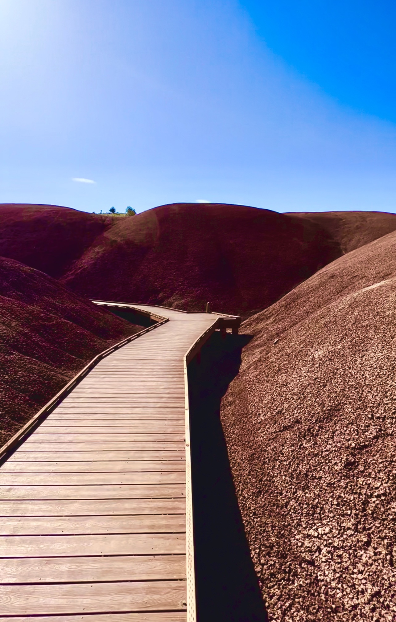
- Stay on the designated trails at all times. The colored mounds are fragile clay paleosols that erode under footprints and stay damaged for decades. The Painted Cove Trail is built as a boardwalk specifically to keep visitors off the soils. Stepping off-trail is illegal in the national monument and visibly destructive.
- No cell service inside the unit. The only public Wi-Fi is at the Painted Hills picnic area. Download offline maps in Google Maps or Gaia GPS before you leave Mitchell or Bend.
- No food or gas inside the unit. Mitchell has gas, a general store, and Tiger Town Brewing Co. for food (about a 15-minute drive from the picnic area). The next-closest gas is in Prineville (1 hour west) or Dayville (40 minutes east).
- Drinking water is seasonal. The picnic area has potable water from May through September only. Bring all your water in winter and shoulder seasons.
- Summer is brutal. July and August routinely hit 95-110 degrees Fahrenheit and the trails have zero shade. The clay soil reaches 130 degrees Fahrenheit in afternoon sun. Hike early morning or evening only in summer; better yet, visit in spring or fall.
- Collecting fossils, rocks, or any natural materials is illegal across the national monument. Take photos, not souvenirs.
- Dogs are allowed on leash on all five trails, but bring extra water and avoid the hottest hours. The hot rock surfaces can burn paw pads.
Where are the Painted Hills?
The Painted Hills are located in the John Day Fossil Beds National Monument, about 9 miles northwest of Mitchell, Oregon. The monument is split into three units that have been preserved separately because the fossil and color layers occur in three geographically distant places. The other two units are the Sheep Rock Unit (45 miles east, with the Thomas Condon Paleontology Center) and the Clarno Unit (75 miles north, with fossils visible in the cliff face).
Driving directions: From Mitchell, take Highway 26 west for about 6 miles, then turn right (north) onto Burnt Ranch Road. Follow Burnt Ranch Road for 5 miles to the unit entrance. From Portland, the drive is about 240 miles via US-26 east (4 hours). From Bend, it’s about 122 miles via US-26 east (2.5 hours). From Eugene, about 230 miles via OR-126 east to US-26 (4 hours).
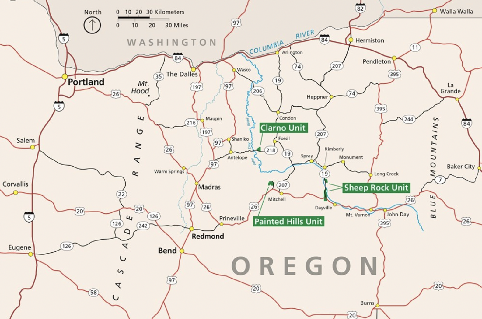
Once you’re on Burnt Ranch Road, the road through the unit is well-maintained gravel and any vehicle can handle it. The first parking lot you hit is the Carroll Rim Trailhead on the right; immediately across is the Painted Hills Overlook parking. The other three trails are spread out farther into the unit, each with its own parking area. The whole unit road is only about 3.5 miles end to end.
If you’re putting together a longer Eastern Oregon road trip and want to see all three units, see our complete 3-day John Day Fossil Beds itinerary for a full weekend trip plan with lodging, food, and driving routes.
The 5 trails of the Painted Hills
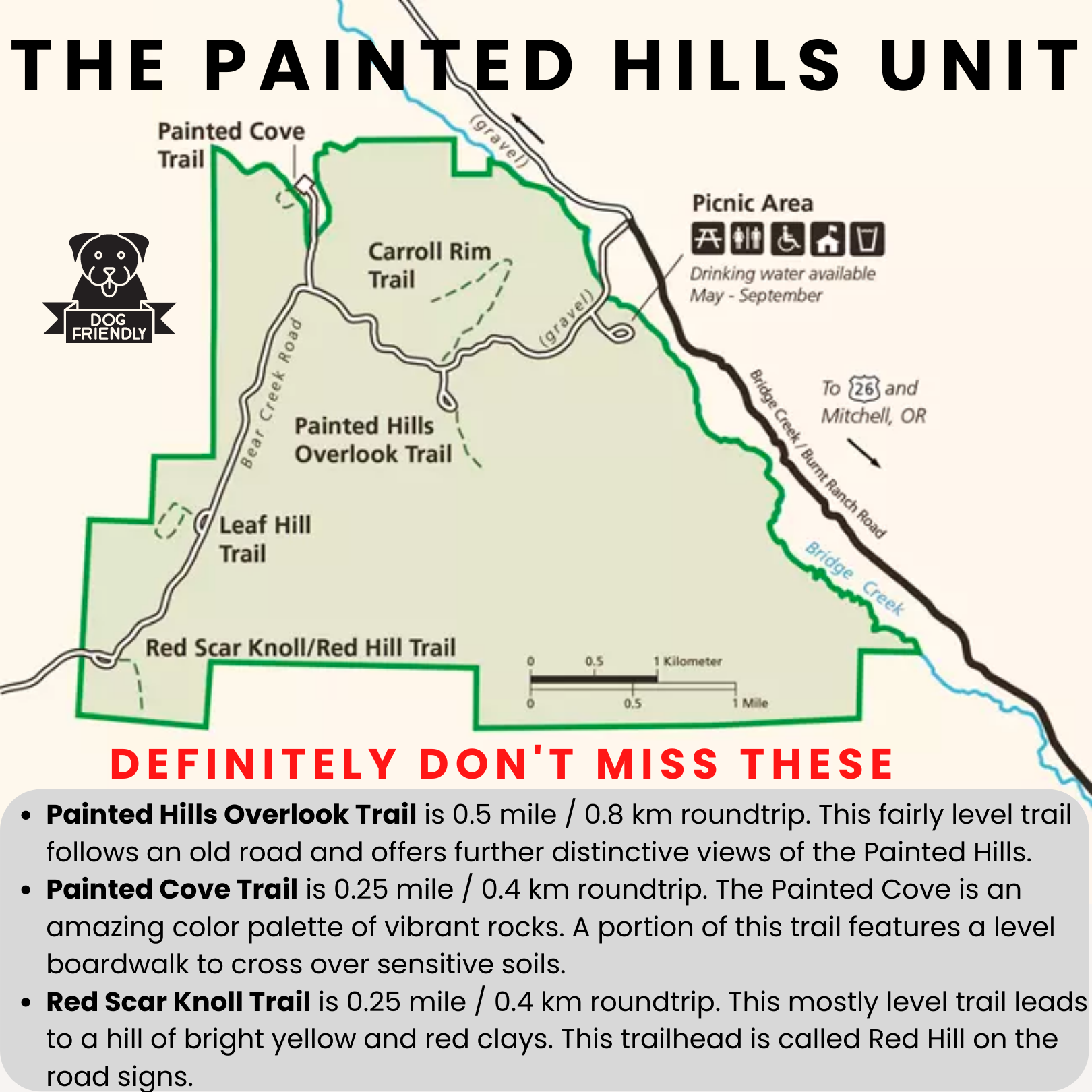
The Painted Hills Unit has five short hikes ranging from 0.25 to 1.6 miles. Combined, they total about 2.6 miles and can be done in 3 to 4 hours including stops. None requires real hiking equipment. The longest, Carroll Rim, is the only one that gets your heart rate up. Each trail has its own dedicated parking area, so you can drive between them rather than connecting them on foot.
If you only have time for one trail, do the Painted Hills Overlook. If you have time for two, add Carroll Rim for the aerial view. If you have all afternoon, do all five. Quick comparison:
| Trail | Distance | Elevation | Difficulty | Best for |
|---|---|---|---|---|
| Painted Hills Overlook | 0.5 mi | ~50 ft | Easy | The iconic view; first-timers |
| Carroll Rim | 1.6 mi | 400 ft | Moderate | Photographers; aerial-style views |
| Painted Cove | 0.25 mi loop | Flat | Easy (boardwalk) | Up-close color; wheelchair access |
| Leaf Hill | 0.25 mi | Flat | Easy | Fossil enthusiasts; kids |
| Red Scar Knoll (Red Hill) | 0.25 mi | ~40 ft | Easy | May wildflowers; the bright red knoll |
Here’s what to expect on each.
1. Painted Hills Overlook Trail
The iconic view. This is the trail you’ve seen on every Oregon postcard and Instagram post. The 0.5-mile out-and-back is mostly level, with a gentle rise to a viewpoint that looks down on the multicolored mounds known as the Painted Ridge. There’s a bench at the end and interpretive signs along the way explaining what you’re seeing. Parking is right at the trailhead, and the trail is wheelchair-accessible to the first viewpoint. Plan on 30 to 45 minutes.
This is the must-do trail if you only have one. The view is best in the last hour before sunset, when low sun saturates the colors.
2. Carroll Rim Trail
The aerial view. The longest and most strenuous trail in the unit, but still completely doable for most visitors. Carroll Rim climbs about 400 feet over 0.8 miles to a ridgeline above the Painted Hills, then continues along the rim for a roughly level walk to a panoramic viewpoint. The first stretch is the steepest; once you’re on the ridge, it’s easy walking with 180-degree views of the Painted Cove, Red Scar Knoll, Sutton Mountain, and the John Day River canyon. Several benches along the rim let you stop and take it in.
The trailhead is across Burnt Ranch Road from the Painted Hills Overlook parking. Plan on 1 to 1.5 hours. This is the only Painted Hills trail with a meaningful climb. Late afternoon is the best time for both the temperature and the light.
3. Painted Cove Trail
The boardwalk close-up. This 0.25-mile loop on a wooden boardwalk takes you directly through the most vivid red and orange clay mounds in the unit. The boardwalk exists specifically to keep visitors off the fragile soils, so the trail is wheelchair- and stroller-friendly. You’re so close to the painted clay you can see the texture of the layers and the cracks in the dried-out claypan surface. Plan on 20 to 30 minutes.
This is the most photographed trail in the unit and one of the most-shared spots on social media. Best light is mid-morning or late afternoon when the boardwalk casts dramatic shadows across the red clay.
4. Leaf Hill Trail
The fossil interpretive trail. Leaf Hill itself does not have any colorful clay; it’s a small unimposing knoll that’s been extensively excavated by paleontologists since the 1920s. The trail loops around the hill on level ground past interpretive signs explaining the leaf fossils that have been found here, preserving the deciduous forest that covered the area 33 million years ago. If you have sharp eyes, you might spot a small rock with a leaf imprint along the trail (look but do not collect).
This is the trail to skip if you’re short on time, unless you have kids or fossil enthusiasts in your party. Plan on 15 to 20 minutes.
5. Red Scar Knoll Trail (Red Hill Trail)
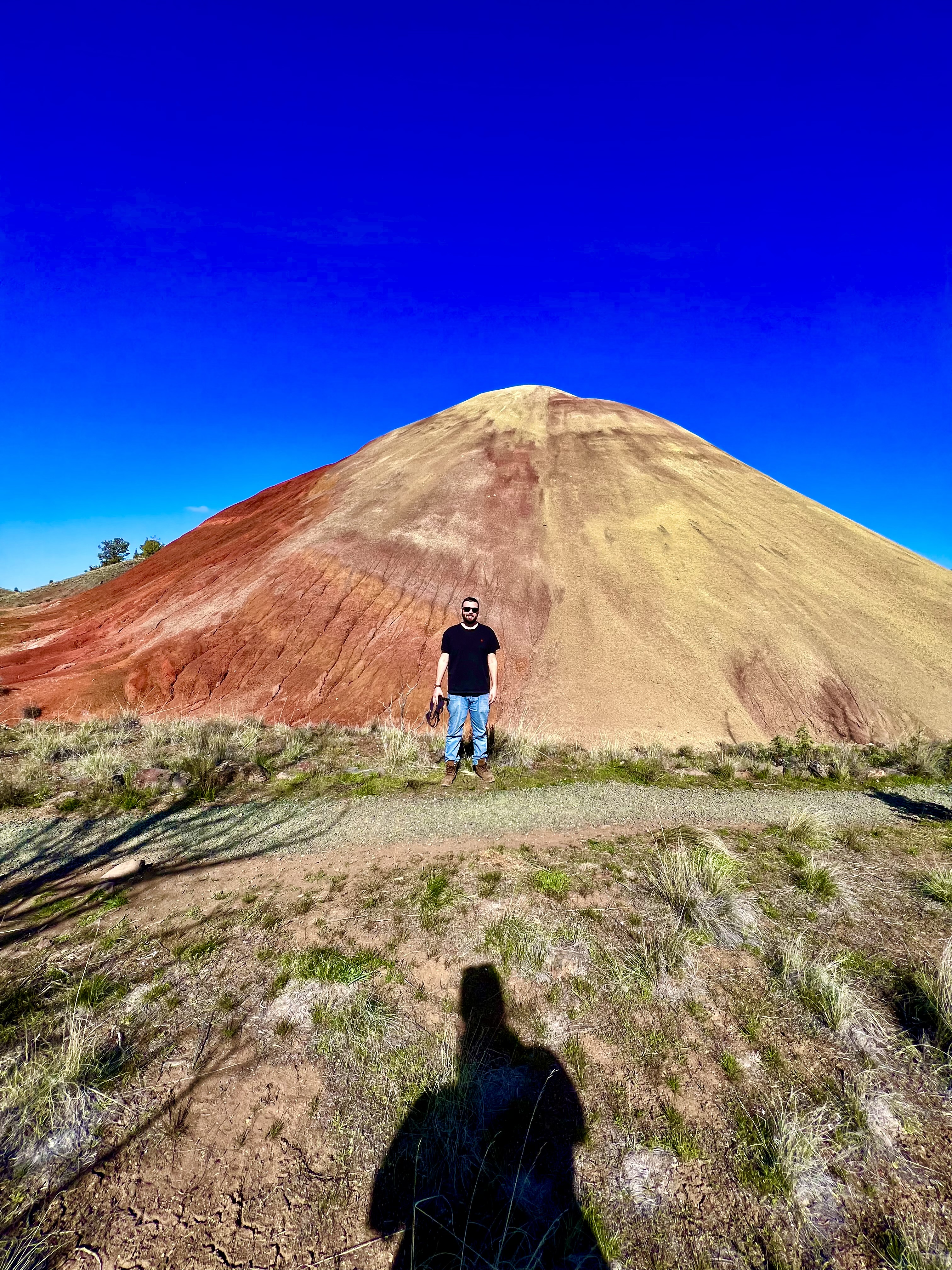
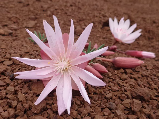
The bright red knoll. Also known as the Red Hill Trail (the road signs use Red Hill), this 0.25-mile out-and-back leads to a brilliantly colored knoll painted in red iron-oxide on one face and yellow on the back side from a drier climate period. The trail crosses a small bridge over a dry gully before reaching the base of the knoll. Pink bitterroot blooms along the trail in May, and prickly pear cactus grows in patches throughout the area. There’s a small bench at the end.
The trailhead is at the far end of the unit road, past the Painted Hills Overlook. Plan on 15 to 20 minutes. Underrated trail; the red is more saturated up close than the more famous Painted Cove.
The colored clay surface is genuinely fragile, and footprints leave visible damage that lasts for years. The hills look soft and inviting; please resist the urge to climb on them. There are also fragile cryptobiotic soil crusts in the open areas between the mounds that take decades to recover from a single footstep.
What makes the Painted Hills “painted”?
The colored bands you see in the hills are different mineral concentrations in volcanic ash paleosols, ancient soils preserved between successive volcanic eruptions. Each major ash fall from the proto-Cascade Range buried the existing landscape, smothered the vegetation, and started a new soil-forming clock. Over millions of years, those soils developed different chemistry depending on the climate of the time (wetter or drier, warmer or cooler), and that chemistry is what we see today as colored bands.
The hills are made of three main soil types layered together: red clay, yellow silt and stone, and black shale. The chemistry of each band is well-understood:
- Red and gold: iron-oxide-rich soils that formed during warmer, wetter periods. The red is essentially rust. The deeper the red, the more iron the soil contained.
- Yellow: rhyolitic ash, about 70 percent silica, mixed with iron and magnesium oxides. These layers reflect drier climate periods when iron oxidized more slowly.
- Black: manganese nodules formed either by plants concentrating manganese into the soil over time or, more likely, by manganese-rich groundwater pooling and drying as the local climate shifted.
- Lavender-gray: rhyolitic lava layers, weathered over millions of years to a soft purple-gray. Best seen in the upper bands at the Painted Hills Overlook.
Hard as it is to imagine standing in the high desert today, the Painted Hills landscape was once a lush forested area at the edge of a warm humid jungle. It fell victim to colossal volcanic eruptions that devastated the region over and over. Many plants and animals were quickly buried in the ash, which preserved them as fossils. The Bridge Creek flora collection from this exact area contains some of the best-preserved leaf fossils in the world, including ancestors of modern oaks, maples, and dawn redwoods.

The Painted Hills today receive only about 12 inches of rain per year, compared to roughly 47 inches during their forested past. Wind, rain, and the seasonal flow of Bridge Creek continue to erode the colors away gradually, and what we see now is just a snapshot of a much larger formation that’s been weathering for tens of millions of years.
Photography tips
The Painted Hills are one of the most photographed landscapes in Oregon, but most photos are taken in the wrong light. A few tips that consistently produce better results:
- Shoot in the last hour before sunset. Midday sun flattens the colors and washes out the red. Low-angle late-afternoon light saturates the reds and creates dramatic shadows in the layered mounds. The first hour after sunrise also works but the unit is east-facing, so morning light is less dramatic on the most-photographed Painted Cove and Painted Hills Overlook side.
- Use a polarizing filter. A circular polarizer cuts glare off the rocks and increases color saturation by 30 to 50 percent. This is the single biggest gear upgrade for Painted Hills photography. Rotate the polarizer until the sky is at its deepest blue.
- Shoot after rain if you can time it. The colors are dramatically more saturated when the soils are wet. Spring storms produce the most vivid conditions; if you see rain in the forecast, plan to shoot the morning after.
- Carroll Rim is the only aerial angle without a drone. Drones are not allowed in the national monument. The Carroll Rim Trail is the only way to get the down-on-the-Painted-Ridge composition that magazines use.
- Bring a wide and a long lens. A wide lens (16-35mm equivalent) handles the panoramic landscapes from the overlooks. A longer lens (70-200mm) compresses the layered ridges nicely and isolates pattern details.
- The boardwalk leading lines work. The Painted Cove boardwalk is a strong leading-line composition. Position yourself so the boardwalk cuts diagonally through the frame.
When to visit + climate
The Painted Hills are open year-round, but the experience is dramatically different between seasons. The closest weather station to the unit is in Mitchell, Oregon (9 miles to the southeast), and the climate is high-desert semi-arid: hot dry summers, cold winters, low overall rainfall.
| Season | What to expect | Pros & cons |
|---|---|---|
| Spring (Apr-May) | Highs 60-69°F, lows 30s-40s. Wildflowers across the unit, occasional spring rain. May is the wettest month (1.65 inches average). Hills are most vivid after rain. | |
| Early summer (Jun) | Highs 70s, lows 40s. Warm and sunny, less wildflowers, longer daylight. Crowds increase noticeably on weekends. | |
| High summer (Jul-Aug) | Highs 86°F average, regularly 95-110°F. Lows 52°F. Dry and exposed; trails have no shade. Rock surfaces hit 130°F. | |
| Fall (Sep-Oct) | Highs 65-77°F, lows 35-45°F. Cool clear weather, golden afternoon light, fewer crowds. September is the photographer’s month. | |
| Winter (Nov-Mar) | Highs 42-54°F, lows 24-34°F. Occasional snow, especially Dec-Feb. Drinking water shut off. Trails open but exposed and windy. |
The cleanest single answer: visit in late April through May, or in September through October. The Painted Hills are most vivid when the soil is damp, so the wet shoulder seasons produce the most saturated colors. Wildflower peak is mid-May; fall colors in the cottonwoods along Bridge Creek peak in mid-October.


Best time of day to visit
Time of day matters as much as time of year for the Painted Hills experience. The colored mounds change dramatically with the angle of the sun: flat and washed-out at midday, deep and saturated in the first and last hours of daylight.
- The last hour before sunset is the single best window. Low-angle warm light hits the south- and west-facing mounds at the Painted Hills Overlook and Painted Cove, deepening the reds and creating dramatic shadows in the layered soils. Arrive 90 minutes before sunset to walk the Painted Hills Overlook trail (0.5 mi), then catch actual sunset from Carroll Rim or the overlook bench.
- The first hour after sunrise is the second-best window, but the unit faces east, so morning light is more dramatic on the back side of the formations and on Red Scar Knoll. Cooler temperatures and zero crowds compensate.
- Avoid 10am to 3pm if photography is the goal. Direct overhead sun flattens the colors, washes out the reds, and creates harsh black shadows that hide the layered detail. The Painted Cove boardwalk still works at midday because the boardwalk itself casts dramatic linear shadows.
- Cloudy or post-rain conditions beat sunny midday almost every time. Diffused light saturates the mineral colors and recently-wet clay glows. If a spring storm is in the forecast, plan to shoot the morning or evening immediately after.
- Sunset times by month: late April ~8 pm, May ~8:30 pm, June-July ~9 pm (long days), August ~8:30 pm, September ~7:30 pm, October ~6:30 pm, winter ~4:30 pm. Plan your arrival accordingly; trail parking lots empty out within 30 minutes of sunset.
- Stargazing bonus: the Painted Hills are in a Bortle Class 2 dark-sky area with essentially no light pollution. The Milky Way is visible from late spring through early fall on moonless nights. Stay in Mitchell or Dayville to combine sunset shots with stargazing.


Recorded extremes for nearby Mitchell, Oregon: highest temperature 107°F in 1972, lowest -27°F in 1983. The Painted Hills receive only about 9 to 16 inches of precipitation annually, with most arriving as rain in spring and snow in winter. The Cascade Range and Ochoco Mountains both create rain-shadow effects that keep the basin dry.
Where to stay near the Painted Hills
The Painted Hills are remote, and lodging in the area is limited and books up fast in spring and fall. Camping is not allowed inside the national monument, so all overnight options are in the surrounding small towns. Below are the better options across price points.
Off-grid cabin and glamping (~$90-$120/night)
Guyon Springs Inn in Dayville (28868 S Fork Road, 541-620-4950) is a 120-acre off-grid farm with one cabin and two wall tents, overlooking the South Fork and John Day River Valleys. Stays include weekend breakfast, plus access to a working farm store with milled cereals, local honey, and fresh-cut flowers. About a 50-minute drive from the Painted Hills Unit. Pet-friendly, family-friendly. Cell service is spotty; plan accordingly.

Mitchell vacation rentals (~$120-$220/night)
Mitchell is the closest town to the Painted Hills (about a 15-minute drive). Several Airbnb properties operate here, including The Sunset Cottage (sleeps up to 15, with kitchen, Wi-Fi, and a backyard, walking distance to Tiger Town Brewing Co. and the general store), and a handful of smaller cabins ranging from one-bedroom hideaways to family-sized homes. Browse Airbnbs in Dayville and Mitchell for the full current selection.
Traditional hotel (~$150/night)
The Best Western John Day Inn in John Day is the easy, predictable option: double or king-sized beds, Wi-Fi, a pool, and hot breakfast included. About a 70-minute drive from the Painted Hills, but closest to John Day’s restaurants and gas. Pet-friendly.
Camping
Camping is not allowed inside the Painted Hills Unit or anywhere in John Day Fossil Beds National Monument. Closest options:
- Bureau of Land Management dispersed camping along the John Day River. Free and primitive; some river-bar sites need 4WD, others are 2WD-accessible from the boat ramp.
- Mitchell tent and RV park in the town of Mitchell (15-20 min drive), with water, restrooms, and electricity.
- Big Bend Campground in Ochoco National Forest, between Prineville and Mitchell along Highway 26. Forested, no water or electricity, restrooms only.
Hotel chains start in Prineville (about an hour west of the Painted Hills) for those who want more amenities.
Things to do near the Painted Hills
The Painted Hills are usually paired with other stops in Eastern Oregon for a multi-day trip. Here are the highest-value additions in the area:
Clarno Unit Fossils & Palisades
3-Day John Day Fossil Beds Trip
Eastern Oregon waterfall hikes


The other 2 units of John Day Fossil Beds
The Painted Hills are one of three separate units of John Day Fossil Beds National Monument. Each unit preserves a different chapter of the same 45-million-year geological story, and each has its own distinct visitor experience. If you have time for more than the Painted Hills, both other units are worth the drive.
The Sheep Rock Unit (45 miles east of Painted Hills) is the largest of the three and the best place to start a multi-day trip because it has the visitor center. The Thomas Condon Paleontology Center displays 500+ fossils with a viewing window into the working lab, plus an 18-minute introductory film. Eight trails range from 300-foot interpretive walks at the Mascall Overlook to the 3-mile Blue Basin Overlook loop with its surreal blue-green claystone formations. The unit also includes the Cant Ranch House, a preserved 1910 sheep-and-cattle ranch homestead.
The Clarno Unit (75 miles north of Painted Hills) is the smallest and farthest west of the three units, with the most dramatic geological feature: the Clarno Palisades, a wall of volcanic mudflow cliffs that preserve fossils of a near-tropical jungle from 44 million years ago. The Trail of Fossils is the only trail in the entire monument where you can see fossils embedded in rock at the trail itself, including petrified logs and leaf imprints. Three short trails (Geologic Time, Trail of Fossils, Arch Trail) total about a mile combined.
Clarno Unit Fossils & Palisades
The Other 7 Wonders of Oregon
The Painted Hills is one of the Seven Wonders of Oregon, alongside six other natural landmarks chosen by Travel Oregon as the state’s most iconic destinations. The full list:
Wallowa Mountains
The Painted Hills
Frequently asked questions
Is there an entrance fee at the Painted Hills?
How many trails are there at the Painted Hills?
How old are the Painted Hills?
What makes the Painted Hills “painted”?
When is the best time to visit the Painted Hills?
Where are the Painted Hills located?
Are dogs allowed at the Painted Hills?
Can you camp at the Painted Hills?
Is there cell service at the Painted Hills?
How long do you need at the Painted Hills?
Can you walk on the Painted Hills?
Is the Carroll Rim Trail worth it?
What other trails or attractions are nearby?
What should I bring to the Painted Hills?
Last updated: May 2026 · Trail conditions, weather, and lodging availability change. Verify the latest at the National Park Service’s Painted Hills page before you go. The trail descriptions, distances, and elevations have been verified against the official NPS site as of May 2026. AllTrails and the NPS site are the best sources for current trail conditions and any temporary closures.