Devils Punch Bowl, Otter Rock, Oregon
An 18-million-year-old collapsed sea cave on the central Oregon Coast that you can walk inside at low tide. The view from above is the easy part. The tide window, the slippery sandstone, and the sneaker waves are why this guide exists.
Devils Punchbowl Quick Stats
Devils Punchbowl is a hollow rock formation on the central Oregon Coast that you can stand directly above, look straight down into, and (if you time the tide right) walk inside. From the viewpoint at the end of 1st Street in Otter Rock, the bowl looks like a giant sandstone cauldron carved out of the cliff. At high tide, surf rushes in through two arched openings and the entire formation churns and roars. At a negative low tide, the floor empties out and you can walk through the north arch into a circular amphitheater of layered sandstone, with the open sky above and tide pools at your feet.
The viewpoint is the part most visitors see. The inside is the part this guide is for. There is a window of two to three hours around low tide when entry is safe, a specific route from the parking lot to the arch on Otter Crest Beach that’s easy to miss, and a list of conditions when you absolutely should not go in. Get those right and the punch bowl is one of the most photogenic geological sights on the entire Oregon Coast. Get them wrong and you become the next news story about coastal rescues.
Two collapsed sea caves and 18 million years of waves
The punch bowl is carved out of the Astoria Formation, a layer of yellowish sandstone and darker siltstone that was deposited along an ancient Oregon shoreline during the Miocene, between roughly 20 and 18 million years ago (per Astoria Formation geology). The rock here is soft compared to the basalt cliffs at Cape Foulweather just north; over millions of years Pacific waves found weak points in the headland and carved out two adjacent sea caves at the base of the cliff. The caves grew, merged into a single large cavity, and eventually the roof collapsed, leaving the bowl-shaped depression you see today.
The floor of the bowl tells you the rest of the story. Volcanic breccia cuts through the Astoria sandstone there, evidence that hot lava was once injected into wet seafloor sediments and shattered the rock above; that’s likely the weak spot the waves exploited first. The walls are full of small round holes about an inch across, bored by piddock clams when this rock was still part of the sea floor. Devils Punchbowl State Natural Area was established in 1929 (originally called Satan’s Cauldron) after F.W. Leadbetter and his wife Caroline Pittock donated the first parcel; the rest was acquired piece by piece through 1971. The site now draws around 900,000 visitors a year (per 2024 visitor figures).
Getting there & parking
Devils Punchbowl is in Otter Rock, a small unincorporated community on Highway 101 between Newport and Depoe Bay. It is one of the most accessible coastal landmarks on the entire Oregon Coast: a few minutes off the highway, two parking lots within a block of the viewpoint, and almost no walking required to see the bowl from above. The walk to enter the bowl from below is also short, just a quarter mile of beach, but it depends entirely on tide.
Drive times to Otter Rock
Devils Punchbowl State Natural Area sits on a headland in the small community of Otter Rock, between Newport and Depoe Bay.
Driving directions
From Highway 101 to the Devils Punchbowl viewpoint
- From Highway 101, look for milepost 133 between Newport (8 miles south) and Depoe Bay (5 miles north).
- Take the Otter Crest Loop / Otter Rock exit and follow signs for Devils Punchbowl State Natural Area.
- Continue into the small community of Otter Rock. The main viewpoint parking lot is at the end of 1st Street.
- If 1st Street is full, drive one block north to the rear parking lot on C Avenue. Public restrooms and picnic tables are at the C Avenue lot.
- Parking is paid as of March 30, 2026: $10 per day for Oregon residents, $12 for out-of-state, or $60/$75 for an annual Oregon State Parks pass. Buy a daily permit at the on-site fee machine.
GPS coordinates: 44.74686°N, 124.0635°W (the viewpoint above the bowl).
Restrooms: Public restrooms at the C Avenue rear parking lot, near the picnic tables. The 1st Street viewpoint lot does not have restrooms.
Cell service: Generally good in Otter Rock; minimal at beach level once you’ve descended.
Fees: Day-use parking permit required as of March 30, 2026. The State Parks permit covers most fee parks statewide on the same day, including Cape Meares and Oceanside.
About the parking situation: Devils Punchbowl was added to the Oregon State Parks day-use fee program along with 21 other parks on March 30, 2026. Parking is limited and only allowed in marked stalls. Do not park on neighborhood streets or private property; the surrounding land is residential and the area cannot absorb overflow. Arrive early on summer weekends and during king tide events when storm watchers fill the lots.
Walkthrough: from the viewpoint to inside the bowl
There are two trips here in one. The viewpoint above the bowl is a 30-second walk and works year-round in any weather. Walking inside the bowl is a separate (and tide-dependent) trip that takes about an hour round trip and only works at low tide. Here’s what each stage looks like.
From the parking lot to the rim
From the 1st Street parking lot, walk 30 seconds west to the fenced overlook. From here you’re looking straight down into the bowl: a hollow rock formation roughly 100 feet across, with two arched openings to the sea on the west and north sides. This is also where you make the call on whether to enter from below. If the floor of the bowl is dry and you can see boulders inside, conditions are good for entering at low tide. If waves are still washing the floor or splashing through the arches, wait or come back another day. During winter storms and king tides, this viewpoint is one of the best surf-watching spots on the Oregon Coast.
The beach access trail
To enter the bowl from below, walk back along 1st Street and turn left onto C Avenue. Continue two blocks until you pass 3rd Street. The beach access trail is on your left, a short paved path that descends about 0.1 miles to Otter Crest Beach. Near the bottom, there’s a small drop-off where the path has eroded; carefully scramble down a short dirt slope. Once you’re on the sand, look south. The cliffs that hold the punch bowl are about 100 yards along the beach to your left. Otter Crest Beach itself is part of the Otter Rock Marine Reserve, with rich tide pools at low tide and a quieter feel than the more famous Oregon Coast beaches.
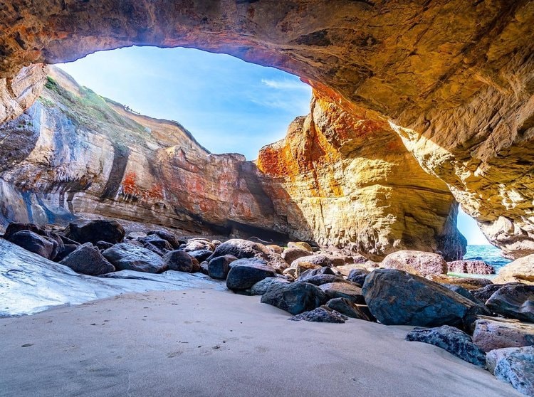
Walking into a 100-foot sandstone amphitheater
At the base of the cliffs, look for two arched openings carved into the sandstone. The north arch is the one you walk through; the west arch is the one ocean waves push through. Step through the arch and you’re standing on the floor of the bowl: a roughly 100-foot-wide amphitheater of yellowish layered sandstone, with the open sky above and the floor strewn with boulders, tide pools, and patches of sand. The walls are pocked with small round holes bored by piddock clams when this rock was sea floor. Allow 30 to 45 minutes inside, then exit the way you came. Watch the openings; sneaker waves can push small surges of water through even on calm days.
Tides & timing
The Devils Punchbowl is a tide-controlled experience. The bowl fills completely at high tide, the openings flood, and entry is impossible. At low tide the floor is dry, the arches are walkable, and you have access to the inside. The window is short and tied to the lunar cycle, not the time of day.
| Tide | What happens | What to do |
|---|---|---|
| Negative low | Floor of the bowl fully exposed, both arches walkable, large beach to walk on, tide pools fully revealed at the base of the cliffs. | |
| Standard low | Floor mostly dry, arches passable, but less margin for error. Sneaker waves can push water through. | |
| Mid / rising | Water in the bowl, arches partially blocked. Risk of being caught inside if the tide turns while you’re there. | |
| High / king tide / storm | Bowl is a churning cauldron. Beach access can be cut off. The viewpoint above is incredible. Inside is impossible and dangerous. |
The simplest plan that works: aim to be on Otter Crest Beach 30 minutes before the day’s lowest tide. Negative tides (lower than the standard average low) are the safest. Plan on being in the bowl for 30 to 45 minutes maximum, then back on the beach above well before the tide turns. Free printed tide tables are available at most businesses in Otter Rock and Newport. Online, the Otter Rock tide forecast shows the day’s tide curve. Always check before you drive out.
Safety: tides, slippery rock, and sneaker waves
The two real risks are misjudging the tide and slipping on wet sandstone.
The bowl fills completely at high tide. If you misread the tide chart or stay too long, the rising water can cut off your exit faster than you expect. People have been seriously injured here. The Oregon State Parks signage at the viewpoint warns explicitly that exploring the sea cave is at your own risk and that the floor of the bowl will fill with water as the tide returns.
The wet sandstone and seaweed-covered rocks at the base of the cliffs are extremely slippery. Slip-and-fall injuries on the way to the bowl are common. Sneaker waves, larger-than-average surges that come in without warning, can push water through the arches even on calm days. Watch the ocean while you’re on the beach approach. Never linger in the openings.
Three things that filter the bad days: visit only on a confirmed negative low tide, never enter during winter storms or king tides, and have a confirmed exit window of at least an hour before the next high tide rolls in. The rising surf zone is fast.
About climbing the rock formation. Oregon State Parks asks visitors not to climb on the bowl walls themselves. The Astoria Formation sandstone is soft, prone to flaking, and full of small piddock-clam holes that look like handholds but break away under weight. Climbing also damages the formation and disturbs the marine life on the floor. Stay on the floor of the bowl, take photos, and exit the way you came.
About the surrounding cliffs. The cliffs above the bowl are unstable in places. From the viewpoint and the trail down to the beach, stay on marked paths. The fenced overlook is the only place that’s clearly safe to lean on; everywhere else, the edge can give way. Keep dogs on leash here for the same reason.
What to see at Devils Punch Bowl
Most visitors stop at the viewpoint, take three photos, and leave within ten minutes. The people who get the most out of the trip take the time to read the rock walls, watch the surf in the bowl from above, and explore the surrounding tide pools and headland.
- The piddock-clam holes in the bowl walls. Look closely at the sandstone walls inside the bowl and you’ll see thousands of small round holes about an inch across. Those were drilled by piddock clams while this rock was still part of the sea floor, millions of years before it was lifted up and carved into a cliff. The holes are a fossil record of what was living in the sediment 18 million years ago.
- Volcanic breccia in the floor. The dark, broken-up rock you can see in patches on the floor of the bowl is volcanic breccia, formed when hot lava was injected explosively into wet seafloor sediments. It’s the geological reason the bowl is here at all; the breccia created a weak spot that waves found and exploited first.
- Tide pools on the north side. The rocks just north of the bowl, on Otter Crest Beach, hold some of the richest tide pools on the central Oregon Coast. Ochre and purple sea stars, green and aggregating anemones, hermit crabs, sculpins, mussels, barnacles, chitons. Look but don’t collect; the area is part of the Otter Rock Marine Reserve.
- Whale spouts in the kelp beds. The kelp beds visible from the viewpoint are a known feeding spot for gray whales. About 200 resident grays feed here through late summer; migrating grays pass through in late December (heading south) and mid-March (heading north). Bring binoculars.
- Storm watching from above. If you’re here during a winter storm or king tide, the viewpoint above the bowl is one of the most dramatic surf-watching spots on the entire coast. The bowl roars and shakes the headland under your feet. Stay back from the unfenced sections of cliff.

Surfing at Otter Rock
Otter Crest Beach, the same stretch of sand you walk to reach the punch bowl, is widely considered the most beginner-friendly surf spot on the entire Oregon Coast, sometimes called the Waikiki of Oregon for its gentle, forgiving wave shape. The Otter Rock headland blocks the worst of the north winds, the bottom is a clean sand break with multiple peaks, and the wave usually breaks both left and right. Winter brings bigger swells and storm waves; late summer is often the calmest and warmest window for first-timers. Pura Vida Surf Shop at the C Avenue corner rents wetsuits and boards, runs lessons, and is the easiest place to confirm conditions before paddling out. Watch for resident harbor seals in the lineup; they’re territorial and you should give them room.
The Otter Crest Loop scenic drive
The two-mile Otter Crest Loop is a one-way coastal road that splits off Highway 101 just north of the punch bowl and rejoins it near Cape Foulweather. The drive itself is quiet, slow, and shaded by old coastal forest, with multiple pullouts where you can stop for ocean views without fighting Highway 101 traffic. The loop also runs past Otter Crest State Scenic Viewpoint, the official observation deck for Cape Foulweather, with interpretive signage about Captain Cook’s 1778 landing and panoramic views from the Yaquina Head Lighthouse south to Cascade Head north. Pair it with the punch bowl for a 30-minute add-on that turns the visit into a half-day on the central coast.
Photographer’s notes
Devils Punchbowl rewards two completely different photo strategies depending on the tide. From above, in surf, it’s a churning power shot. From below, at a negative low tide, it’s an architectural shot of layered sandstone and dramatic light through the open top. Both work, neither one captures the place by itself.
- The signature inside-the-bowl shot looks straight up through the open top. Stand near the center of the bowl floor, point your camera up, and let the circular rim of sandstone frame the sky. Time it for late morning to early afternoon when the sun is high enough to drop direct light into the bowl. This is the shot that fills travel guides; it works because the bowl’s geometry is naturally an aperture.
- From the viewpoint, shoot the surf cycle. Watch the bowl from above for a few minutes before shooting. Waves come in pulses; the most dramatic moment is right after a big wave fills the bowl and the foam churns. Use a fast shutter (1/500 or faster) to freeze the spray. A polarizer cuts glare on the wet sandstone.
- Bring a wide lens for inside. A 14 to 24mm full-frame equivalent captures the full rim of the bowl from inside. Anything tighter clips the shot. The walls are far enough apart that getting them all in one frame requires going wide.
- Sunset doesn’t help here. Unlike most Oregon Coast subjects, Devils Punch Bowl is not a sunset shot. The bowl is most photogenic at midday when light reaches the floor. Visit during golden hour for the surrounding coastline (especially Cape Foulweather) and shoot the bowl at midday for the inside.
- Watch the ocean while shooting. Sneaker waves splash through the openings without warning. Keep your gear on a strap, don’t set it down on the floor of the bowl, and be ready to move. The bowl is a beautiful place for camera water damage.
- Drone with caution. Recreational drone use over the state natural area is technically allowed but the airspace is shared with seabirds, especially in spring. Fly low, fly briefly, and stay out of the bowl itself; a crash inside the wet bowl with the surf is unrecoverable.
What to pack for Devils Punchbowl
Short trip, short list. The two design constraints are wet rock and the tide window.
Nearby stops to combine
Devils Punchbowl sits in the middle of one of the best stretches of the Oregon Coast for stacking stops. Within 30 minutes by car you can reach a dozen scenic viewpoints, the Whale Watching Capital of the Oregon Coast, and the largest seabird colonies south of Alaska.
Three iconic stops within walking distance of the parking lot
Mo’s Restaurant sits right next to the C Avenue rear parking lot. Mo’s has been an Oregon Coast institution since 1946 and is known for clam chowder served in a sourdough bread bowl. The Otter Rock location has full ocean views from most tables. Open daily, no reservations.
Cliffside Coffee & Sweets is a few doors down and is the easiest pre-bowl coffee, post-bowl ice cream stop in Otter Rock. Small shop, friendly owners, real espresso.
Newport (8 miles south) and Depoe Bay (5 miles north) both have a much wider selection if you want a sit-down dinner. Try South Beach Fish Market and the Newport Bayfront for fresh seafood, or any of the bay-view restaurants in Depoe Bay above the seawall.
Frequently asked questions
Where is Devils Punch Bowl in Oregon?
Why is it called the Devils Punch Bowl?
How was the Devils Punch Bowl formed?
Can you walk into the Devils Punch Bowl?
Is there a parking fee at Devils Punchbowl State Natural Area?
What is the best tide to enter the Devils Punch Bowl?
How dangerous is the Devils Punchbowl?
How long is the hike to the Devils Punchbowl?
What can I see in the tide pools nearby?
Can you see whales from Devils Punchbowl?
Is Devils Punchbowl dog friendly?
When is the best time to visit Devils Punch Bowl?
Are there bathrooms at Devils Punchbowl?
What other Oregon Coast spots are nearby?
Last updated: May 2026 · Tide windows, parking fees, and bowl conditions can change quickly. Devils Punchbowl access is through Devils Punchbowl State Natural Area, which began requiring a day-use parking permit on March 30, 2026. Otter Crest Beach and the bowl interior are part of the protected Marine Gardens; do not collect anything. For tide forecasts before your visit, check the Devils Punch Bowl tide chart.