Tunnel Beach, Oceanside, Oregon
A hidden Oregon Coast beach reached only through a 90-foot tunnel carved through the base of Maxwell Point in 1926. The tunnel is the easy part. The tide window, the falling rocks, and the standing water inside are why this guide exists.
Quick Stats
Tunnel Beach is a stretch of sand, cobble, and driftwood that you cannot see from anywhere in Oceanside. It sits behind Maxwell Point, a 161-foot basalt headland that once cut off the entire north stretch of beach. To get there, you walk through a 90-foot tunnel that two brothers blasted through that headland in 1926 with dynamite and shovels. The first half is a concrete bunker. The second half is raw basalt. The middle is dark and often ankle-deep in water.
The tunnel is the part everyone Instagrams. The part that’s actually worth the trip is what’s on the other side: tide pools full of sea stars, views straight out at Three Arch Rocks National Wildlife Refuge, and a beach that empties out completely on weekday mornings. This guide covers how to time the tide so you don’t get trapped, what the parking situation looks like since the new state-park fee took effect, and what to actually do once you’ve made it through.
Two brothers, a resort dream, and a Miocene basalt headland
Maxwell Point is a lobe of Columbia River Basalt erupted during the Miocene, between 13 and 17 million years ago. It is the same hard, dark, columnar rock that built nearby Cape Meares and the offshore stacks of Three Arch Rocks. Maxwell Point and Three Arch Rocks were once part of a single connected lava headland; wave erosion has been carving them apart for millions of years (per the Oregon Hikers Field Guide). Tunnel Beach sits in the cove that erosion has scooped between the headland and what’s left of those stacks.
The tunnel itself is a much more recent story. Brothers H.H. and J.H. Rosenberg bought 320 acres of oceanfront from the estate of John W. Maxwell in 1921, platted the town of Oceanside in 1922, and tried to build a coast resort to rival Cliff House. In 1926 they hired a miner with blasting powder to drive a 90-foot passage through the base of Maxwell Point so resort guests could reach the beaches on the other side. The dance hall, hotel, and most of the original resort buildings are long gone. The tunnel is what’s left. Landslides have buried it more than once (most notably in 1979, when it stayed closed for almost two decades, and again in late 2020), but storms and the Oregon State Parks Department keep flushing it out.
Getting there & parking
Tunnel Beach is in Oceanside, a small unincorporated community on the Three Capes Scenic Loop, about 11 miles west of Tillamook. The tunnel entrance is at the north end of Oceanside Beach, accessed from the Oceanside Beach State Recreation Site parking lot. There is no public transit to Oceanside; you need a car. Cell service is weak in town and unreliable on the beach itself.
Drive times to Oceanside
Tunnel Beach sits behind Maxwell Point, the dark headland at the north end of Oceanside Beach.
Driving directions
From Highway 101 to the Oceanside Beach parking lot
- From Highway 101 in Tillamook, head west on Third Street, which becomes the Netarts Highway / OR-131.
- Follow OR-131 about 7 miles through farmland to Netarts. Continue on the Netarts Oceanside Highway as it bends north toward the coast.
- About 4 miles past Netarts, the highway descends into the village of Oceanside. The state recreation site lot is on your left at the bottom of the hill, on Pacific Avenue NW.
- Park in the Oceanside Beach State Recreation Site lot. Parking is paid as of March 30, 2026: $10 per day for Oregon residents, $12 for out-of-state, or $60/$75 for an annual Oregon State Parks pass.
- Take the public access ramp at the southwest corner of the lot down to the beach. Maxwell Point is the dark headland to your right (north).
GPS coordinates: 45.4638°N, 123.9736°W (Tunnel Beach itself, north of Maxwell Point).
Restrooms: Public restrooms in the Oceanside Beach State Recreation Site parking lot, just up the ramp from the beach. There are no facilities on the other side of the tunnel.
Cell service: Spotty in Oceanside in general; minimal to none on Tunnel Beach itself.
Fees: Day-use parking permit required. Buy a daily permit at the on-site fee machine, or use a 12-month Oregon State Parks permit if you have one. The State Parks permit covers most fee parks statewide on the same day.
About the parking situation: The fee is new. Until March 30, 2026, parking at Oceanside Beach was free. The Oregon State Parks Department added the site to its day-use fee program along with 21 other parks, citing maintenance costs. Local residents have raised concerns that visitors will skip the paid lot in favor of the residential streets above the beach, which are too narrow for emergency vehicles. Use the state parks lot. Skipping it puts a strain on a town that already absorbs more traffic than it can handle on summer weekends.
Walkthrough: from the parking lot to the other side
This is not a hike. It is more like a beach walk with one strange and memorable obstacle in the middle. The whole thing takes about 15 minutes one way at a casual pace, longer if you stop in the tunnel to admire the basalt or take photos. Here is what each part of the route actually feels like.
Down the access ramp
From the state parks lot, take the paved ramp down to Oceanside Beach. The ramp drops about 30 feet over a short concrete switchback and lands you on the sand. To your right is Maxwell Point, the dark basalt headland that hides the tunnel. To your left and offshore are Three Arch Rocks. Check the surf as soon as you reach the sand. If waves are slamming against the base of Maxwell Point, the tunnel is going to be wet at best and impassable at worst.
A quarter mile of sand
Walk north along the sand toward Maxwell Point. It is about a quarter mile from the access ramp to the base of the headland. The walking is easy on packed sand at low tide and tougher in soft dry sand at higher tide. As you approach the cliff, the beach narrows and you start to scramble over rounded boulders the size of coolers. The tunnel mouth appears as a dark vertical slot in the basalt at the base of the cliff. There is usually a small handful of other people coming and going. If you are alone, that is a good sign about the tide window.
Ninety feet through Maxwell Point
The tunnel is two-toned. The first half is concrete, originally built bunker-style, with a flat concrete floor and small viewing holes punched out toward the ocean. About midway it transitions into raw basalt: rough walls, an uneven cobble-and-sand floor, and almost no light. Turn on your flashlight before you step in. The middle is genuinely dark, even on a sunny day. The water on the floor can reach ankle depth depending on the tide. Walk slowly. The whole passage takes maybe a minute. You’ll know you’re nearly through when you see daylight reflecting off basalt walls in front of you.
Tunnel Beach
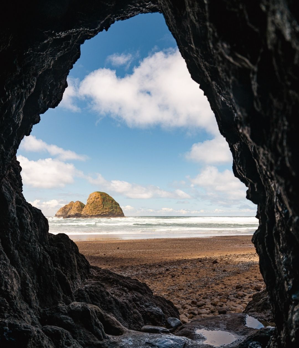
Step out of the tunnel and the first thing you see is a wider, wilder, much quieter beach. Tunnel Beach itself is a curved stretch of sand, cobble, and driftwood backed by sheer basalt cliffs. Three Arch Rocks sit half a mile offshore. The tide pools at the cliff base hold sea stars, anemones, and crabs. North of here is Lost Boy Beach, but do not push past Tunnel Beach unless you have confirmed extreme low tide and a return window. People have been stranded on Lost Boy Beach for hours. Most visitors spend an hour or so on Tunnel Beach itself, then turn around.
Tides & timing
Tunnel Beach is the kind of place where the tide doesn’t just affect your experience; it determines whether the visit is possible at all. The tunnel mouth sits a few feet above the average high-tide line. During winter storms and king tides, surf pushes through the tunnel and floods it with debris, driftwood, and rocks. Even on a calm summer day, an incoming tide can make the tunnel uncomfortably wet on your way out.
| Tide | What happens | What to do |
|---|---|---|
| Outgoing / low | Tunnel floor exposed, beach access easy, tide pools fully revealed, plenty of beach to walk on the other side. Maxwell Point’s seaward base may even be passable. | |
| Mid / rising | Standing water in the tunnel up to ankle depth. Beach narrowing on both sides. Tide pools partially submerged. | |
| High | Surf hits the base of Maxwell Point. Tunnel can be fully flooded. Less beach on the other side. Risk of getting cut off. | |
| King tide / storm surf | Waves push through the entire tunnel with debris and rocks. Falling rock risk on the headland is highest. |
The simplest plan that works for almost any visit: aim to enter the tunnel two to three hours before low tide. That gives you a falling tide on the way in (so the beach is still opening up), low tide while you are exploring (the optimal window), and a generous buffer on the way back before the tide turns. Check the Oceanside tide forecast the morning of your trip. Free printed tide tables are available at most businesses in Oceanside, Netarts, and Tillamook.
Safety: rocks, surf, and being prepared
The two real risks are timing the tide wrong and falling rocks from Maxwell Point.
Maxwell Point is structurally unstable basalt. The exterior of the headland has been buried by landslides multiple times since 1926, including a 1979 slide that closed the tunnel for almost two decades and another in late 2020. The Oregon State Parks signage at the tunnel entrance warns of falling rocks, especially after heavy rain or stormy weather. The risk is real, even if most visits are uneventful.
The tide is the other big variable. Sneaker waves can push surf into the tunnel mouth at high tide, and king tides during winter can flood the entire passage with debris. People have been temporarily trapped on the far side when an incoming tide made the tunnel unsafe to re-enter. Never turn your back on the ocean, watch your tide window, and budget extra time on the return.
Three things that filter the bad days: check the tide forecast and aim for outgoing tide, do not enter the tunnel during or right after a winter storm, and bring a flashlight strong enough that you don’t have to feel your way along the wall.
If you are claustrophobic, the tunnel is short enough to be manageable for most people. The middle is the only stretch where you cannot see daylight from either end. From the moment you start to feel boxed in until you can see the exit is about 20 to 30 seconds at a normal walking pace. Many claustrophobic visitors handle it fine; some find the wet rocks and dim light hard. If you have someone with you, walk close together. If you are solo, time your trip to busy weekend afternoons when there is a steady stream of other people through the tunnel.
About Lost Boy Beach. The next beach north of Tunnel Beach, accessible only at extreme low tide by walking around or scrambling rocks, is genuinely treacherous. It has no return route except the way you came in. Visitors have been trapped for hours waiting for tides to drop again. Unless you have hiked it before, have a confirmed multi-hour low-tide window, and have a partner, treat Lost Boy Beach as off-limits and turn around at Tunnel Beach.
What to see at Tunnel Beach
The beach itself is the destination, but the surrounding cliffs and offshore rocks hide a surprising amount of marine life and geology. Most visitors walk through the tunnel, take a few photos, and leave within 20 minutes. The people who get the most out of the trip slow down and look closely.
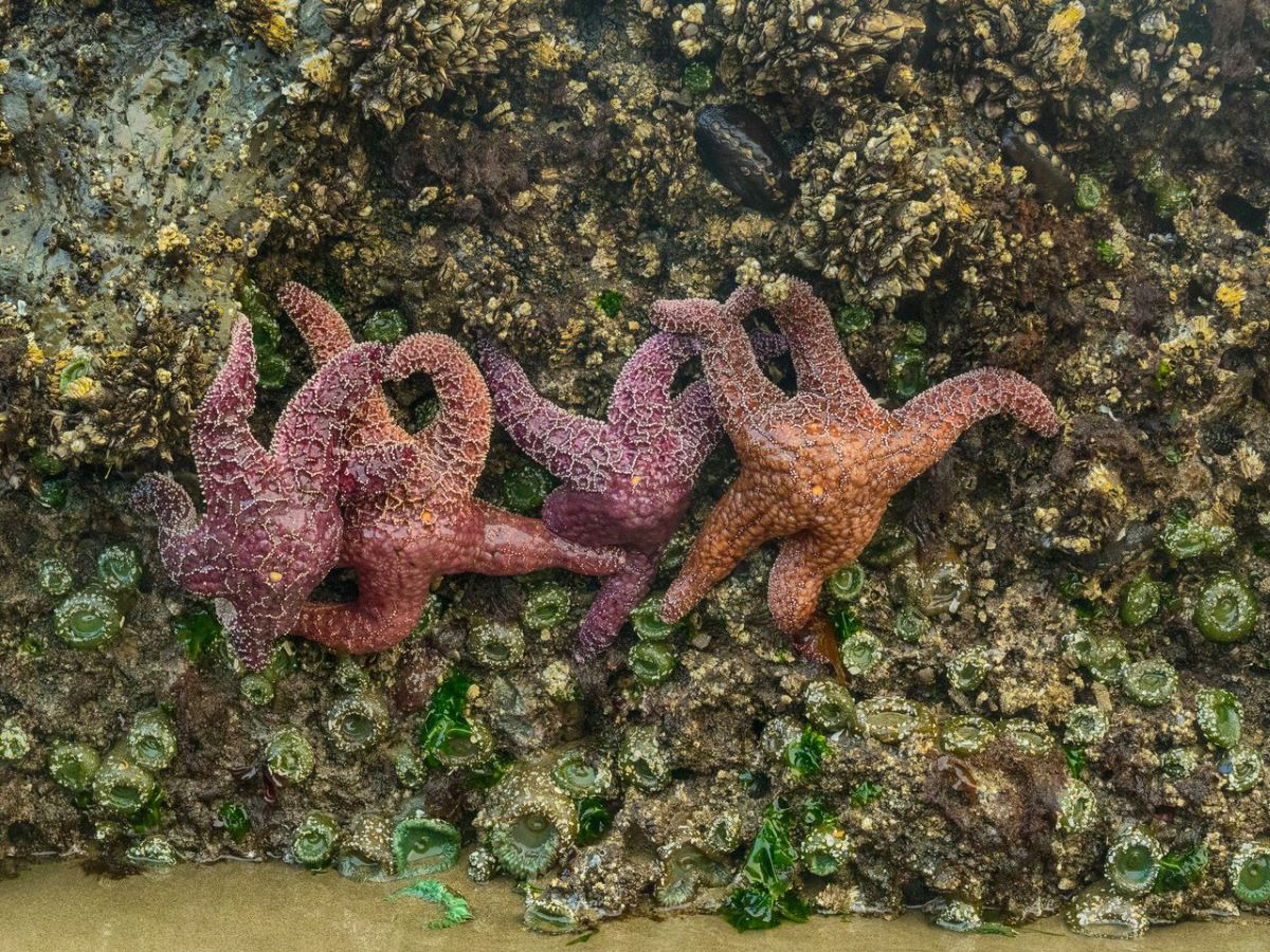
- Tide pools at the base of Maxwell Point. When the tide is out, the rocks at the seaward base of the headland (the rocks you scrambled over to reach the tunnel) hold dense colonies of mussels, gooseneck barnacles, ochre and purple sea stars, green sea anemones, hermit crabs, and sculpins. This is one of the most accessible tide pool spots on the north Oregon Coast. Watch your footing on wet rock and never collect anything.
- Three Arch Rocks offshore. The cluster of three large rocks and six smaller ones half a mile offshore is Three Arch Rocks National Wildlife Refuge, established by Theodore Roosevelt in 1907. It is one of the smallest designated wilderness areas in the country, the largest seabird nesting colony in Oregon, and the only Steller sea lion pupping site on the north Oregon Coast. Bring binoculars. On windy days you can sometimes hear the sea lions from the beach.
- Driftwood and basalt. Tunnel Beach collects huge driftwood logs that wash up during winter storms. The basalt cliffs above the beach show the columnar jointing typical of Columbia River Basalt; look up and you can see hexagonal column ends in cross-section.
- Agates and rockhounding. Oceanside Beach (south of the tunnel) and Tunnel Beach itself are well-known agate-hunting spots, especially in winter when storm surf strips away the top layer of sand and reveals fresh stones. Look for clear and banded agates, jaspers, and zeolites. Oregon allows up to one gallon of rocks per day for personal use.
- The arch (gone, but worth knowing about). Until 2004, one of the offshore stacks visible from Tunnel Beach had a dramatic arch eroded through it; that arch collapsed and the rock has continued to erode since. The stacks you see today are the next stage of the same process that built the cove.
Photographer’s notes
Tunnel Beach is two distinct photo subjects in one trip: the tunnel itself, and the beach beyond it. They demand different settings, different timing, and different gear strategies. Here is what works.
- Shoot the classic tunnel-frame composition from inside, looking out. The signature Tunnel Beach photo is taken from a few feet inside the tunnel, framing the sea stacks and beach through the natural arch. Stand back about 10 to 15 feet from the exit, expose for the bright outdoor scene (the tunnel walls go nearly black, which is what you want), and shoot wide. A 16 to 24mm lens captures the irregular tunnel arch and full beach beyond.
- Sunset is the assignment, but plan around the tide. The west-facing tunnel mouth lines up with the setting sun in the right months (roughly April to August). Magic hour through the tunnel arch is one of the best photo windows on the Oregon Coast. The catch: sunset often coincides with rising tide. Time it carefully. You want low or outgoing tide during the golden hour, not high tide.
- Bring a tripod for the tunnel interior. Inside the tunnel, light levels drop fast. Handheld shots come out blurry or noisy. A small travel tripod and a 1- to 4-second exposure pulls texture out of the basalt walls and renders the floor cobbles in sharp detail. Use a 2-second self-timer to avoid camera shake.
- Foreground something. The beach beyond the tunnel is dramatic but flat in the middle of the day. Add foreground: driftwood, a tide pool, the silhouette of the tunnel arch, a person for scale. Three Arch Rocks make a strong background subject if you can get them to line up behind a foreground element.
- Drone with caution. The airspace over Tunnel Beach itself is OK for recreational drone use, but the airspace over Three Arch Rocks National Wildlife Refuge is restricted. Aircraft (including drones) are required to maintain 2,000 feet clearance from the refuge. Stay over the beach, fly low, keep flights short, and never fly out toward the offshore rocks.
- Protect your gear from salt spray and sand. Even on calm days the air at the tunnel mouth is full of fine spray. Wipe lenses regularly, keep an extra microfiber cloth in your bag, and put gear back in a closed pack between shots. Sand and salt are the two things that kill cameras at coastal locations.
What to pack for Tunnel Beach
This is a short walk with a few specific items that make a real difference. The two design constraints are wet feet and dim light.
Nearby stops to combine
Tunnel Beach is on the Three Capes Scenic Loop, one of the best road-trip routes on the Oregon Coast. If you have driven this far, stack at least one or two more stops on the trip.
Frequently asked questions
Where is Tunnel Beach in Oregon?
How long is the tunnel to Tunnel Beach?
Who built the tunnel and when?
Do I need a flashlight for the tunnel?
Is there a parking fee at Oceanside Beach State Recreation Site?
When is the best tide to visit Tunnel Beach?
How dangerous is Tunnel Beach?
What is on the other side of the tunnel?
What can I see in the tide pools?
Can you see Three Arch Rocks from Tunnel Beach?
Is Tunnel Beach dog friendly?
How long does the Tunnel Beach walk take?
Can you access Tunnel Beach without going through the tunnel?
What other Oregon Coast spots are nearby?
Last updated: May 2026 · Tide windows, parking access, and tunnel conditions can change quickly. Tunnel Beach access is via Oceanside Beach State Recreation Site, which began requiring a day-use parking permit on March 30, 2026. Three Arch Rocks National Wildlife Refuge offshore is closed to public landing year-round; view it from the beach. For tide forecasts before your visit, check the Oceanside tide chart.