Thor’s Well, Yachats, Oregon
A natural saltwater fountain on the Oregon Coast that looks like a hole draining the Pacific Ocean. The well itself is the easy part. Timing the tide window, navigating slippery basalt, and avoiding sneaker waves are why this guide exists.
Thor’s Well Quick Stats
Thor’s Well, the so-called Drainpipe of the Pacific, is a natural saltwater fountain on the central Oregon Coast that looks, at high tide, like the ocean is draining into a hole in the basalt. As waves push in, water surges up through a roughly 20-foot-deep collapsed sea cave and shoots into the air; as they pull back, the well appears to drain. The optical illusion is dramatic enough that the spot has earned three nicknames over the years: the Drainpipe of the Pacific, Satan’s Cauldron, and the Gate to Hell. None of them quite capture how good the photo is when you nail the timing.
The catch is the timing. Thor’s Well is mostly empty and unimpressive at low tide. The geyser-like surge happens in a short window from about an hour before high tide to an hour after. Outside that window, you’ve driven a long way for not much. Inside that window, you’re standing on uneven basalt that’s actively wet and slippery, with surf splashing close enough to remind you that sneaker waves have killed people on this stretch of coastline. This guide covers when to go, where to park since the Cape Perpetua Visitor Center went into its 2025-2026 remodel, and the safety stuff that the small warning signs at the trailhead don’t quite spell out.
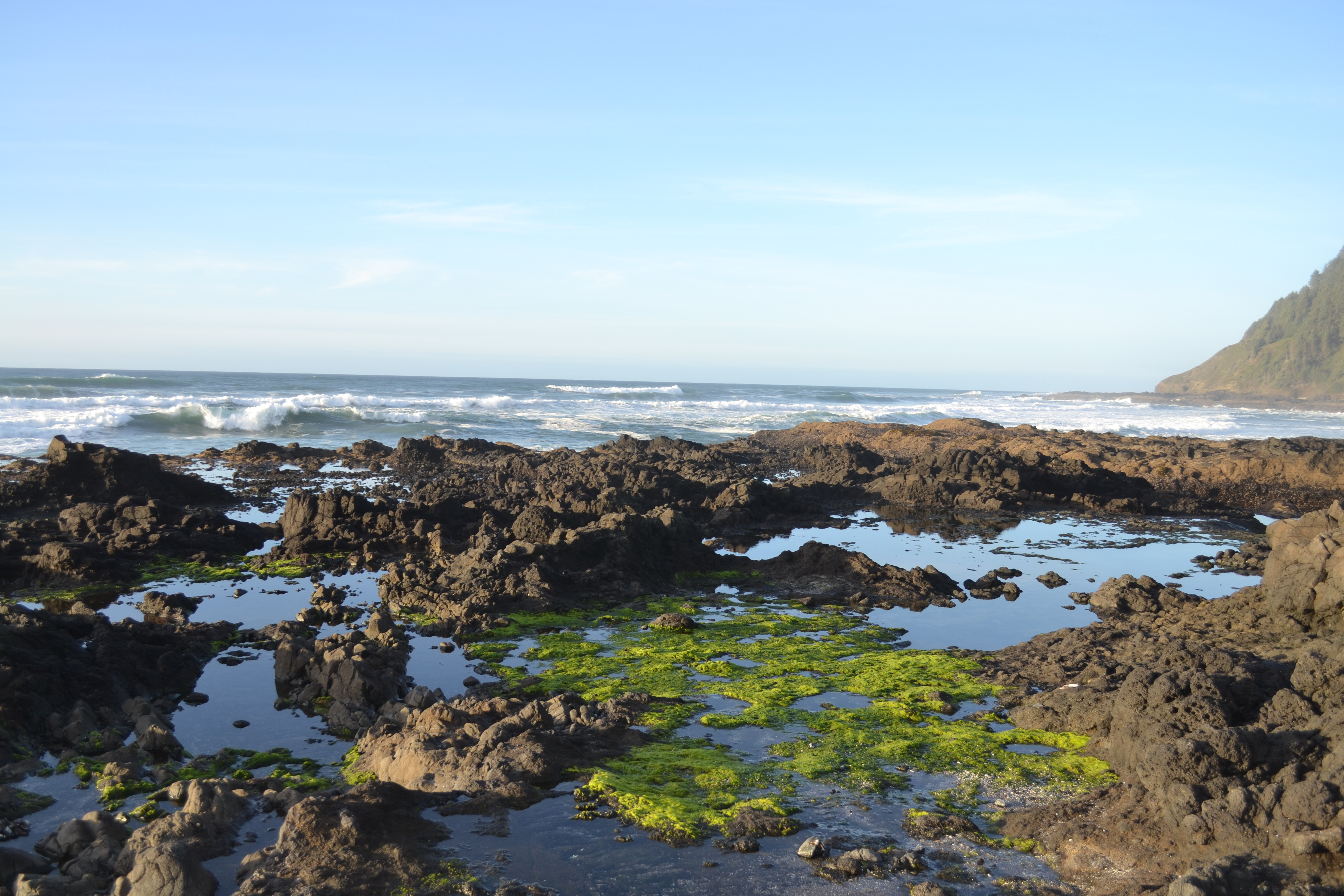
A collapsed sea cave in the basalt of an ancient shield volcano
The basalt shoreline at Cape Perpetua is what’s left of an extinct shield volcano that once dominated this part of the central Oregon Coast. Over millions of years of uplift, sea-level change, and Pacific wave action, that volcanic rock has been carved into the high cliffs, basalt platforms, and sea caves you see today. Cape Perpetua itself rises 800 feet above the ocean and is the highest point on the entire Oregon Coast accessible by car (per the Cape Perpetua reference). On a clear day, the view from the top reaches 70 miles down the coast and 37 miles out to sea.
Thor’s Well sits on a marine platform at the base of that headland. Geologists believe the well started as a typical sea cave eroded into the basalt cliff face by waves attacking a softer zone in the rock. Over thousands of years the cave grew, the roof thinned, and eventually the top collapsed; the bottom also opened to the ocean, leaving the bowl-shaped formation with openings at both ends. Coastal expert Gary Hayes (publisher of Coast Explorer Magazine) describes formations like Thor’s Well and the nearby Spouting Horn as classic collapsed sea caves shaped over geologic time, where tide-driven water surges from below send water shooting upward (per Travel Oregon’s Ask Oregon feature). The same process formed the Devil’s Churn just north and is still actively reshaping the cliffs above.
Getting there & parking
Thor’s Well is in the Cape Perpetua Scenic Area, about 3 miles south of Yachats and 14 miles north of Florence on Highway 101. The site is managed by the U.S. Forest Service as part of the Siuslaw National Forest. Two parking lots serve the well: the larger Cape Perpetua Visitor Center lot (with restrooms and trail maps when open) and a smaller pull-off directly off Highway 101 just north of the Cook’s Chasm Bridge. Both are paved, both connect to the Captain Cook Trail, and both require a $5 day-use fee or a valid Forest Service recreation pass.
Drive times to Cape Perpetua
Cape Perpetua Scenic Area, three miles south of Yachats. Thor’s Well sits on the basalt rock shelf right against the Pacific.
Driving directions
From Highway 101 to Thor’s Well
- From Highway 101, drive south through Yachats for about 3 miles to the Cape Perpetua Scenic Area.
- The first turnoff on your left is Devil’s Churn (separate lot, free 15-minute spots). Continue south.
- Next is the Cape Perpetua Visitor Center turnoff on your left. Use this lot if you want the longer scenic walk and full Captain Cook Trail loop. Note: the Visitor Center building itself is closed mid-December through May 2025-2026 for remodeling, but parking and trail access remain open.
- For the shortest walk to Thor’s Well, continue south past the Visitor Center turnoff for about half a mile to the small Cook’s Chasm parking lot on the right (west) side of Highway 101, just before the Cook’s Chasm Bridge.
- Pay the $5 day-use fee at the QR code on the lot signage, or display a Northwest Forest Pass / America the Beautiful Pass / interagency Forest Service pass on your dashboard.
GPS coordinates: 44.2775°N, 124.1130°W (Thor’s Well itself).
Restrooms: Public restrooms at the Cape Perpetua Visitor Center year-round (outside the building when the building is closed for remodeling). No restrooms at the Cook’s Chasm pull-off.
Cell service: Spotty at the parking areas, intermittent on the trail and at the well. Download maps before you arrive.
Fees: $5 day-use fee at all Cape Perpetua parking lots, payable by QR code or covered by an interagency forest pass.
Parking fills up. The small Cook’s Chasm lot has only about 20 spaces and fills fast on summer weekends and during king tide events. If it’s full when you arrive, double back to the Visitor Center lot and walk the full Captain Cook Trail loop (1 mile round trip): one of the best short walks in the entire Cape Perpetua area and you pass interesting features along the way.
Walkthrough: trail to the well
The trail itself is paved and very easy. The hard part is the off-trail scramble across the basalt shelf to actually reach the rim of the well, which only makes sense to attempt during the right tide window. Here’s how each stage looks.
Captain Cook Trail and Thor’s Well via AllTrails: 0.6 mi loop, 98 ft elevation gain, 4.7 stars from 1,213 reviews.
From the parking lot to the basalt shelf
From the Cook’s Chasm pull-off, the trail descends through wind-sculpted coastal vegetation toward the ocean. From the Visitor Center lot, the trail crosses under Highway 101 through a small tunnel, passes an old Civilian Conservation Corps camp site and Native American shell middens, and joins the same paved path. Either way, the trail ends at a basalt overlook roughly 30 feet above the surf, with the rock shelf and Thor’s Well laid out in front of you. From here you can see Cook’s Chasm to the south, the Spouting Horn beyond it, and the well itself out on the flat. This is the decision point: if the surf looks safe and the tide is rising toward high, you can scramble down. If the rocks are getting hammered or the tide is dropping, photograph from the upland and stay on the trail.
Crossing the rock shelf to the rim
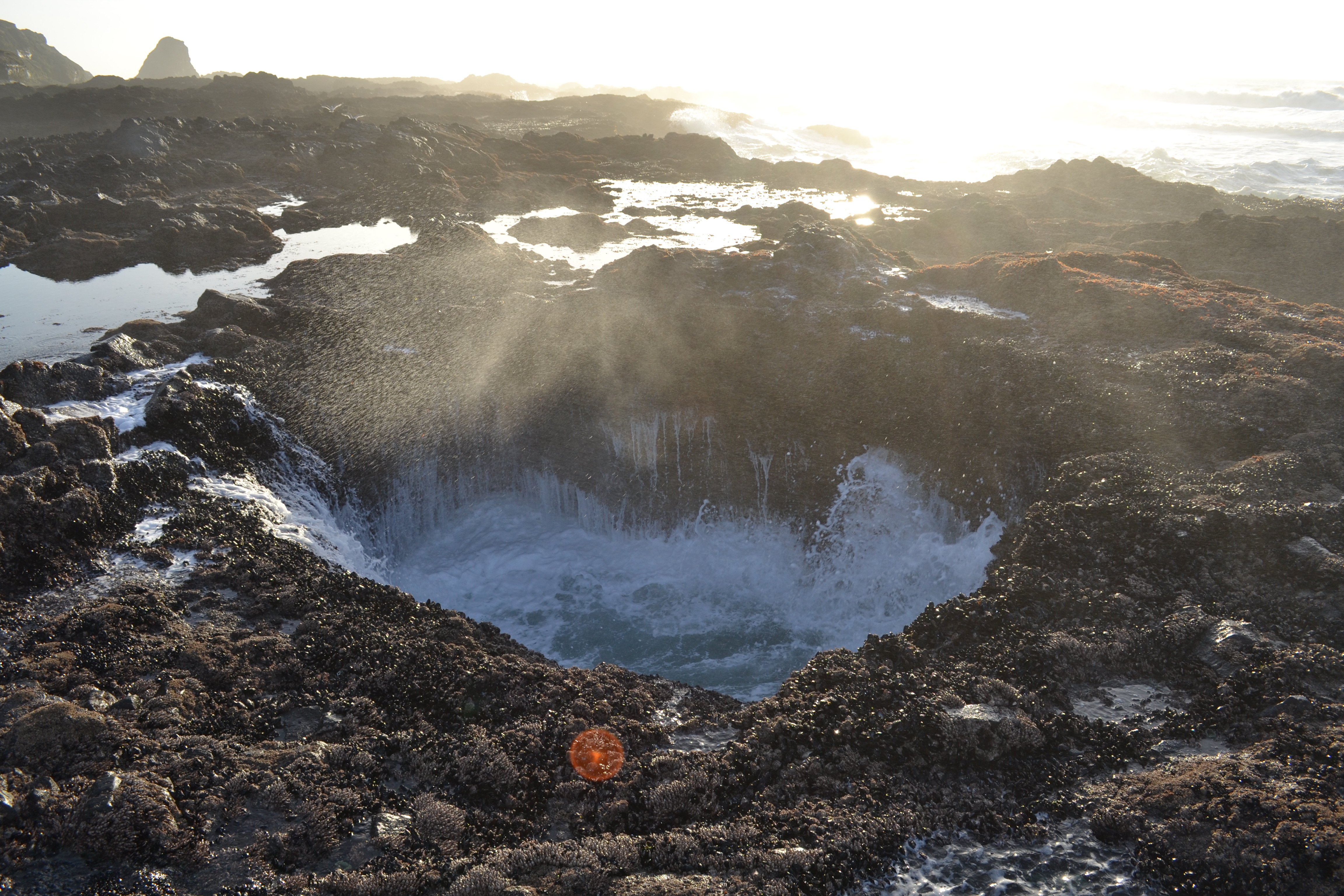
From the overlook, a rough use-trail descends to the basalt shelf. There are no steps, no rails, and no defined path; you pick your way across the rock to the well, which sits roughly 100 yards out toward the surf. The basalt is uneven, often wet, and frequently covered with thin green seaweed that’s slick as ice. Take it slow. The well itself is unmarked and easy to walk right past at low tide; it’s a roughly 6-foot-wide circular hole in the rock, about 20 feet deep. At low tide it’s drained and not very impressive. As the tide rises, it begins to fill and surge.
Watching the well surge
From about 1 hour before high tide to 1 hour after, Thor’s Well puts on its show. Each incoming wave pushes water up through the bottom opening; the well fills, then water shoots up and out the top, sometimes 40 feet into the air, before draining back down. On king tides or stormy days the surge is enormous. Stay several yards back from the rim; the well lip has no fence, the surrounding rock is wet, and a bigger-than-average wave can knock you straight in. The best vantage is upwind of the well so you don’t get fully soaked. Allow 30 to 45 minutes at the rim, then exit the rock shelf the way you came.
Tides & timing
Thor’s Well is the most tide-dependent attraction on the central Oregon Coast. Get the timing right and the spout is one of the most spectacular natural sights you’ll ever see in person. Get it wrong and the well is a small empty hole in the rock that’s not worth the drive. Here’s how to read the tide chart for this specific spot.
| Tide | What happens | What to do |
|---|---|---|
| ~1 hr before high | Well begins to fill and surge through the openings. Surf is rising but not at its biggest. Best balance of drama and safety. | |
| High tide | Maximum surge. Spout reaches highest. Surf is biggest and most dangerous; sneaker waves are at their worst window. | |
| ~1 hr after high | Well is still active but surge is decreasing. Water level around the rim is starting to drop. | |
| Low tide | Well is mostly drained. The spout effect is gone. Tide pools nearby are accessible and rich. | |
| King tide / storm | Massive surge, dangerous surf, sneaker waves common. Photographers’ favorite, also the most dangerous. |
The simplest plan that works: aim to be on the basalt rock shelf about 45 minutes before the day’s predicted high tide. That gives you time to walk out, set up, and watch the well as it builds toward maximum surge. Stay on the rocks for 30 to 45 minutes through the high-tide window, then walk back to the upland trail. Always check before you drive out: the Yachats tide forecast covers Thor’s Well. King tides typically occur in late November, December, and January, and produce the biggest surges of the year, and the highest risk of being swept off the rocks.
Safety: sneaker waves & slippery basalt
The two real risks at Thor’s Well are sneaker waves and slipping on wet basalt.
Sneaker waves, larger-than-average surges that arrive without warning, have killed visitors along Cape Perpetua in recent years. The basalt rock shelf in front of Thor’s Well is a low marine platform with no barrier between you and the surf. A bigger wave can knock you down or sweep you off the rocks before you have a chance to react. Watch the ocean while you’re on the rocks. Never turn your back to the surf. Stay back from the cliff edge between waves.
The basalt itself is slippery anywhere there’s seaweed, salt spray, or running water. The rocks look grippy when dry but turn to ice when wet. Wear closed-toe shoes with rubber soles and trekking soles, or hiking boots. Move slowly. Falls on this rock cause cuts and broken bones routinely; the basalt is hard and uneven.
Three filters that handle most bad days: avoid Thor’s Well during winter storms and king tides (view only from the upland trail), don’t stand within several feet of the well’s rim during incoming surf, and never bring a young child or unstable footing onto the basalt during a rising tide.
About falling in. The well is roughly 20 feet deep with jagged basalt walls and a narrow exit through which water surges in and out. A fall in during high tide would be a rescue scenario at best and likely fatal. The lip of the well has no fence or barrier; visitors have to maintain their own buffer. If you’re shooting photos, set up at least 10 to 15 feet back from the rim and stay aware of approaching waves at all times.
About the surrounding rocks. The basalt platform extends out toward the surf and is heavily fractured. Cracks fill with seawater that can be many feet deep. Don’t jump across cracks; walk around. The same care applies near Cook’s Chasm just south, where waves funnel into a narrow gash and visitors have died trying to leap across.
What to see at Thor’s Well
Most visitors see the well at high tide and leave. The visitors who get the most out of Cape Perpetua plan their trip to catch the well at one tide and the surrounding tide pools at the opposite tide. The site rewards a half-day visit far better than a quick stop.
- Cook’s Chasm and the Spouting Horn. Just south of Thor’s Well, Cook’s Chasm is a narrow basalt fissure where waves funnel into a tight slot and crash dramatically. On the south side of the chasm, the Spouting Horn is a sea cave that shoots a vertical geyser of seawater straight up at high tide. The Captain Cook Trail loop passes both. Same tide window as Thor’s Well; same hazards.
- Devil’s Churn. Half a mile north of Thor’s Well, Devil’s Churn is another collapsed sea cave that has become a long crack in the coastal rock. Waves entering and exiting collide and explode upward in a froth. It has its own parking lot off Highway 101 with a viewpoint and a short trail down to the lava rock. Free 15-minute spots if you’re just passing through.
- Cape Perpetua Overlook (800 ft). A 1.6-mile drive up Forest Road 55 from Highway 101 takes you to the highest point on the entire Oregon Coast accessible by car. The CCC-built stone shelter on top offers panoramic views 70 miles down the coast and 37 miles out to sea on a clear day. Excellent gray whale watching in winter and spring.
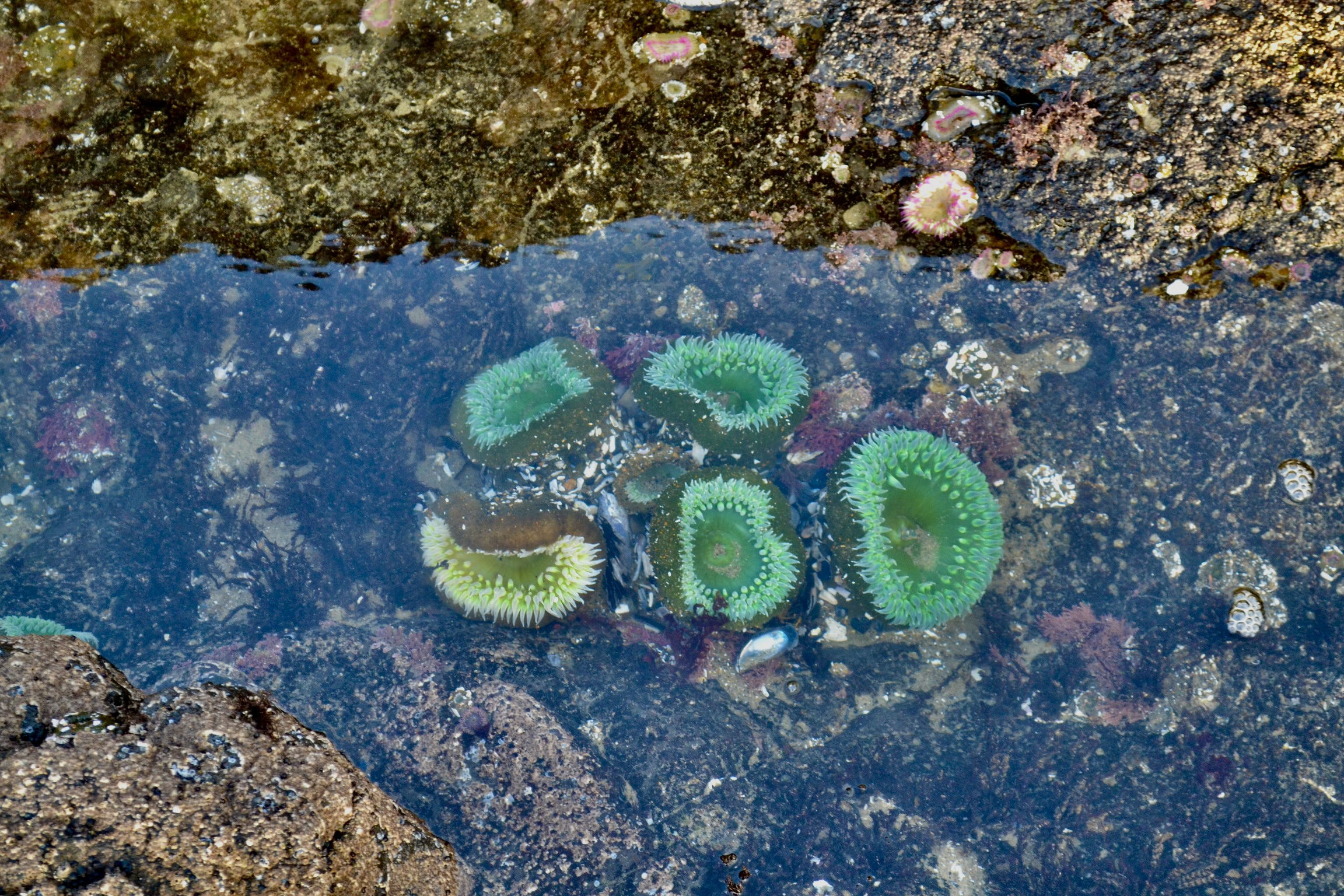
- Tide pools (best at low tide). The basalt shelf at Thor’s Well holds rich tide pools: ochre and purple sea stars, green and aggregating anemones, sea urchins, hermit crabs, sculpins, mussels, barnacles, and chitons. The Cape Perpetua Marine Reserve protects the entire intertidal here; look but don’t collect.
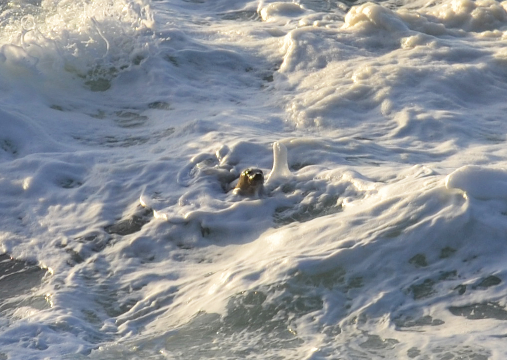
- Harbor seals in the surf. Harbor seals occasionally appear in the surf zone near Thor’s Well, riding the waves and hauling out on offshore rocks. They’re not always there, but when they are, they’re memorable.
- The Silent Sentinel of the Siuslaw. A short drive back inland from Cape Perpetua takes you to the Giant Spruce Trail and a 600-year-old Sitka spruce that stands 185 feet tall with a 40-foot circumference. It was designated an Oregon Heritage Tree in 2007.
The tide pools at Thor’s Well
If you arrive at low tide and the well isn’t doing much, the tide pools are exceptional. The basalt shelf to the north of the well holds a network of pools that fill at high tide and drain at low, leaving the marine life concentrated and visible. We’ve watched ochre sea stars wedge themselves into rock cracks, anemones close around fingers held just above the water, and sea urchins crowd into hollows worn smooth by the same waves that built the well. The Cape Perpetua Marine Reserve protects all of this; do not collect anything, and stay off the animals themselves.
Cape Perpetua Overlook (the opposite-perspective shot)
Most visitors to Thor’s Well never drive up to the Cape Perpetua Overlook, the highest point on the entire Oregon Coast accessible by car at 800 feet. From the small Highway 101 turnoff, Forest Road 55 climbs roughly 1.6 miles through old-growth Sitka spruce and Douglas fir to a top-of-cape parking area. From there, the short Whispering Spruce Trail (0.4 mi) loops past a CCC-built stone shelter with panoramic views 70 miles down the coast and 37 miles out to sea on a clear day. The shelter was used as a coastal observation post during World War II. It’s the best gray whale watching spot in the entire Cape Perpetua complex during winter and spring migrations, and the view straight down on Thor’s Well from the overlook is the photo nobody takes because they don’t realize you can. For a longer hike, the Saint Perpetua Trail (4.4 mi loop, 4.8 stars from over 1,400 AllTrails reviews) climbs from the Visitor Center to the same overlook on foot.
Green sea anemones
Aggregating green anemones cover the bottom of many of the deeper pools at Thor’s Well, opening into bright green flowers when submerged. They’re surprisingly vivid against the dark basalt. Touch them only with the back of a wet hand if at all; sunscreen, soap, or salt from your skin can damage them.
Purple sea urchins
Purple sea urchins burrow into the basalt itself, slowly grinding pits in the rock with their teeth over the course of decades. The pits often hold the same urchin for its entire 30+ year life. Look for them in the deeper pools and shaded crevices.
When the well is dry, the pools come alive
The same tide window that makes the well unimpressive is the perfect time to explore the rest of the basalt shelf. The pools hold an entire ecosystem that’s only accessible for a few hours a day. Plan your trip around both windows if you can: arrive at low tide, walk the pools and the trail, and stay until the rising tide brings the well to life.
Thor’s Well photography: tips & timing
The Drainpipe of the Pacific is one of the most photographed coastal features in Oregon, which means there are a thousand versions of the same shot online. Getting yours to stand out comes down to timing, weather, and a willingness to wait for the right moment.
- Sunset is the iconic shot. The classic Thor’s Well photo is taken at high tide right at sunset, with the sun setting directly behind the well and golden light backlighting the spout. Tide and light only line up like this a handful of times a year. Apps like PhotoPills will tell you when. When it does line up, expect a crowd of photographers on the rocks; arrive early.
- Use a fast shutter for the spout. 1/500 second or faster freezes the surge mid-air. Slower shutters (1/30) give you the silky-water effect you’ll see in landscape postcards. A neutral-density filter helps if you want long-exposure motion in daylight.
- Wide angle for context, telephoto for the surge. A 16 to 24mm lens captures Thor’s Well in its setting, with surrounding rocks and surf. A 70 to 200mm lets you isolate the spout against the horizon at high tide; this is the best lens for getting the geyser-like geometry without including a crowd of photographers in the frame.
- Bring more rain protection than you think you need. Cameras die at Thor’s Well. Salt spray and direct splashes from the spout will hit your gear unless you set up well back from the rim. Consider a cheap rain cover or a plastic bag, and have a microfiber cloth ready.
- Drone with extreme caution. Recreational drone use over Cape Perpetua is technically allowed but the airspace shares with seabirds, the wind off the Pacific is strong and unpredictable, and a crash into the surf is unrecoverable. Fly briefly, fly high enough to clear the platform, and don’t fly over the well itself.
- Cook’s Chasm makes a better video subject. If you brought video gear, Cook’s Chasm just south of Thor’s Well gives you continuous wave action funneling into a narrow slot, which photographs and videos beautifully. The Spouting Horn on the south side of the chasm sometimes erupts higher than Thor’s Well itself.
Want to see Will’s footage? Below is a TikTok clip from @oregontailsadventures showing Thor’s Well in action at high tide.
@oregontailsadventures The best of Thors Wells 💦😍💦 Read the full blog post at Oregontails.org #oregon #thorswelloregon #pnw #OscarsAtHome ♬ Love You So – The King Khan & BBQ Show
What to pack for Thor’s Well
Short list. The real design constraints are wet basalt, salt spray, and the chance that a sneaker wave hits you full-on.
Nearby stops to combine
The Drainpipe of the Pacific sits on one of the most scenic stretches of the Oregon Coast. Within a 30-minute drive you can reach a major sea lion haul-out, the Whale Watching Capital of the Oregon Coast, the Sea Lion Caves, and several other coastal attractions worth a half-day each.
Yachats is the closest food stop
Yachats (6 minutes north of Thor’s Well) is a small town with a tight cluster of cafes, brewpubs, and seafood restaurants on Highway 101. Luna Sea Fish House is known for fish and chips and ocean views. Yachats Brewing & Farmstore serves local beer and farm-to-table food. Green Salmon Coffee Company is the standard pre-tide-chart morning stop.
Florence (25 minutes south) and Newport (45 minutes north) both have wider sit-down dinner options. The Cape Perpetua area itself has no food or coffee outside the seasonal espresso stand at the Devil’s Churn lot.
Frequently asked questions
Where is Thor’s Well in Oregon?
What is Thor’s Well?
How was Thor’s Well formed?
How deep is Thor’s Well?
When is the best time to see Thor’s Well?
Is there a parking fee at Thor’s Well?
How long is the hike to Thor’s Well?
How dangerous is Thor’s Well?
What is Thor’s Well named after?
Is Thor’s Well dog friendly?
What wildlife can I see at Thor’s Well?
Is the Cape Perpetua Visitor Center open?
What other Cape Perpetua features are nearby?
How far is Thor’s Well from Portland?
Last updated: May 2026 · Tide windows, parking fees, and Visitor Center status can change quickly. Thor’s Well sits in the Cape Perpetua Scenic Area within Siuslaw National Forest; a $5 day-use fee or valid Forest Service pass is required at all parking lots. The Cape Perpetua Visitor Center building is closed mid-December through May 2026 for remodeling, but parking and trails remain open. For tide forecasts before your visit, check the Yachats tide chart.