
Oregon Geography: Mountains, Rivers & the Cascade Divide
Oregon is a state of two halves. West of the Cascades is temperate rainforest, fog-bound coast, and 100 inches of rain a year. East of the Cascades is high desert, sagebrush steppe, and snow-line volcanoes. A complete physical-geography guide to the 9th-largest state.
Oregon at a Glance
Oregon’s geography is famously contradictory. In a single state you can walk through a Pacific temperate rainforest at sunrise, drive across an alpine pass under glacier-fed snowfields by lunch, and stand in a sagebrush sea where the next house is 30 miles away by sunset. The state covers 98,381 square miles, ranks 9th in the U.S. by area, and contains 11 named mountain ranges, the deepest lake in the country, the longest entirely-public ocean coastline of any state, and one of the only true high deserts in North America. All within a single state border.
The reason for that variety is the Cascade Range: a chain of volcanic peaks running north to south through the middle of the state. The Cascades catch most of the rain coming off the Pacific and dump it on the western third of Oregon, then leave the eastern two-thirds in a permanent rain shadow. That single fact, more than any other, explains why the geography of Oregon looks the way it does.
Two Oregons, one state
If you draw a line down the spine of the Cascades, you split Oregon into two completely different worlds. West of the line: 40 to 100+ inches of rain per year, dense Douglas fir forests, the Willamette Valley farmlands, 95% of the state’s population. East of the line: 8 to 14 inches of rain per year, sagebrush, lava flows, ranchland, and the kind of empty horizon that takes most visitors by surprise. The state highway map looks like a single state. The climate map looks like two.
Where Oregon sits on the map
Oregon is a Pacific Northwest state in the northwestern United States, bordered by Washington to the north, Idaho to the east, Nevada and California to the south, and the Pacific Ocean to the west. The Columbia River forms most of the northern border with Washington, and the Snake River carves the eastern border with Idaho. The 42nd parallel marks the southern border with Nevada and California, a straight line surveyed in 1819 as part of the Adams-Onís Treaty between the United States and Spain.

Oregon is about 295 miles north to south and 395 miles east to west. It is the 9th-largest state by area but the 27th most populous, with about 4.2 million residents. About 70% of those residents live in the Willamette Valley, the agricultural lowland between the Cascades and the Coast Range. Outside the valley, the population thins out fast. Harney County in the southeast covers 10,228 square miles (larger than Massachusetts, Connecticut, and Rhode Island combined) and has fewer than 8,000 residents.
Geographically, Oregon is part of the larger Pacific Northwest region, which also includes Washington, Idaho, and (depending on how you draw the line) parts of Montana and British Columbia. The state’s three big organizing features are the Pacific coastline, the Cascade Range, and the Columbia River. Almost everything else, including the climate, the ecoregions, the population centers, and the highway map, follows from those three.
The Cascade divide
The Cascade Range is the single most important geographic feature in Oregon. It runs the entire length of the state, north to south, splitting Oregon into a wet maritime west and a dry continental east. Every climate map, every ecoregion map, and every population density map of Oregon is essentially a map of this one mountain range.
The range is volcanic in origin, part of the larger Cascade Volcanic Arc that extends from northern California to British Columbia. The arc exists because the Juan de Fuca tectonic plate is being slowly forced under the North American plate off the Oregon coast, melting as it descends and feeding magma to the surface as a chain of stratovolcanoes. The Oregon Cascades include Mt. Hood, Mt. Jefferson, Three Fingered Jack, Mt. Washington, the Three Sisters, Mt. Bachelor, Newberry Volcano, Mt. Thielsen, Mt. McLoughlin, and (formerly) Mt. Mazama, which collapsed about 7,700 years ago to form Crater Lake.

The crest of the Cascades is the climate border. Pacific air masses move east, hit the western slopes of the range, and dump 80 to 150 inches of precipitation per year on places like Government Camp and McKenzie Pass. The same air, drier and warmer after descending the eastern slope, reaches Bend with about 12 inches of precipitation per year and Burns with about 10. The contrast is sharp enough that you can drive from a moss-draped cedar forest into a sagebrush flat in under an hour on US-20 east of Sisters.
The range also splits Oregon into two cultural and economic worlds. West of the Cascades is the urbanized “Wet Side” of timber, agriculture, and tech. East of the Cascades is the rural “Dry Side” of cattle, hay, and dryland wheat. The political and cultural map of the state still tracks the rain map. Read more about the seven travel regions of Oregon →
Mountain ranges of Oregon
Oregon has 11 named mountain ranges, but the state is dominated by five major ones. Together they cover roughly half the surface area and define the watersheds, the climate, and the recreational character of the state.
1. The Cascade Range
The defining mountain range of Oregon. Runs about 350 miles north to south through the state, with peaks averaging 5,000 to 8,000 feet and a string of volcanic summits over 10,000 feet (Mt. Hood, Mt. Jefferson, the Three Sisters). The crest is the rain shadow line and the Pacific Crest Trail (PCT) follows it for 455 miles within Oregon. Silver Falls State Park, the Columbia River Gorge, and Crater Lake National Park are all part of the Cascades.
2. The Coast Range
A lower, older range parallel to the Pacific, 200 miles long and rarely exceeding 4,000 feet. The summits include Mary’s Peak (4,097 ft, the highest point in the Coast Range) and Saddle Mountain (3,290 ft). The range is densely forested with Douglas fir, western hemlock, and Sitka spruce, and receives some of the heaviest rainfall in the lower 48 states. The range catches Pacific moisture before it reaches the Willamette Valley, contributing to the valley’s milder, drier climate compared to the coast itself.

3. The Wallowa Mountains
The most dramatic range in Oregon and one of the most isolated. The “Alps of Oregon” sit in the far northeast corner, with granite peaks rising sharply above the surrounding plateau. Sacajawea Peak (9,838 ft) and the Matterhorn (9,826 ft) are the high points, and the Eagle Cap Wilderness contains 60+ alpine lakes carved by Pleistocene glaciers. The range is home to some of Oregon’s best backpacking and is a 6-hour drive from Portland, which keeps it less crowded than the Cascades.
4. The Blue Mountains
A complex range covering much of northeastern Oregon, 7,000 to 9,000 feet at the highest summits. The Blues include several sub-ranges (the Strawberry Mountains, the Elkhorn Mountains, the Greenhorn Mountains, the Ochocos) and contain the headwaters of the John Day, the Grande Ronde, and the Powder rivers. The Oregon Trail crossed the Blue Mountains as the last major obstacle before the Columbia River, a stretch infamous for its difficulty in the 1840s. Pendleton sits on the western flank.
5. The Klamath Mountains
The southwestern corner of Oregon, extending into northern California. The Klamaths are some of the oldest mountains in the Pacific Northwest, with rocks dating back 400+ million years, and they contain one of the most botanically diverse temperate forests in the world (over 3,500 native plant species). The Siskiyou Mountains are the Oregon section. The range is heavily forested, deeply dissected by canyons, and home to the Wild and Scenic Rogue and Umpqua rivers.
Beyond these five, Oregon has several smaller but locally important ranges: the Steens Mountain in the southeast (a single 9,733-foot fault-block ridge that towers above the Alvord Desert), the Ochoco Mountains (an extension of the Blues), the Calapooya Mountains (between the Willamette and Umpqua valleys), and the Mahogany Mountains in the southeastern corner near the Nevada border.
The Oregon Coast
Oregon has 363 miles of Pacific coastline, running from the Columbia River at Astoria south to the California border at Brookings. What makes the coast geographically distinctive isn’t the length, it’s the combination of volcanic sea stacks, steep headlands, sand dunes, and the fact that all of it is publicly owned. Every inch of wet sand on the Oregon Coast belongs to the public, the result of the 1967 Beach Bill signed by Governor Tom McCall.
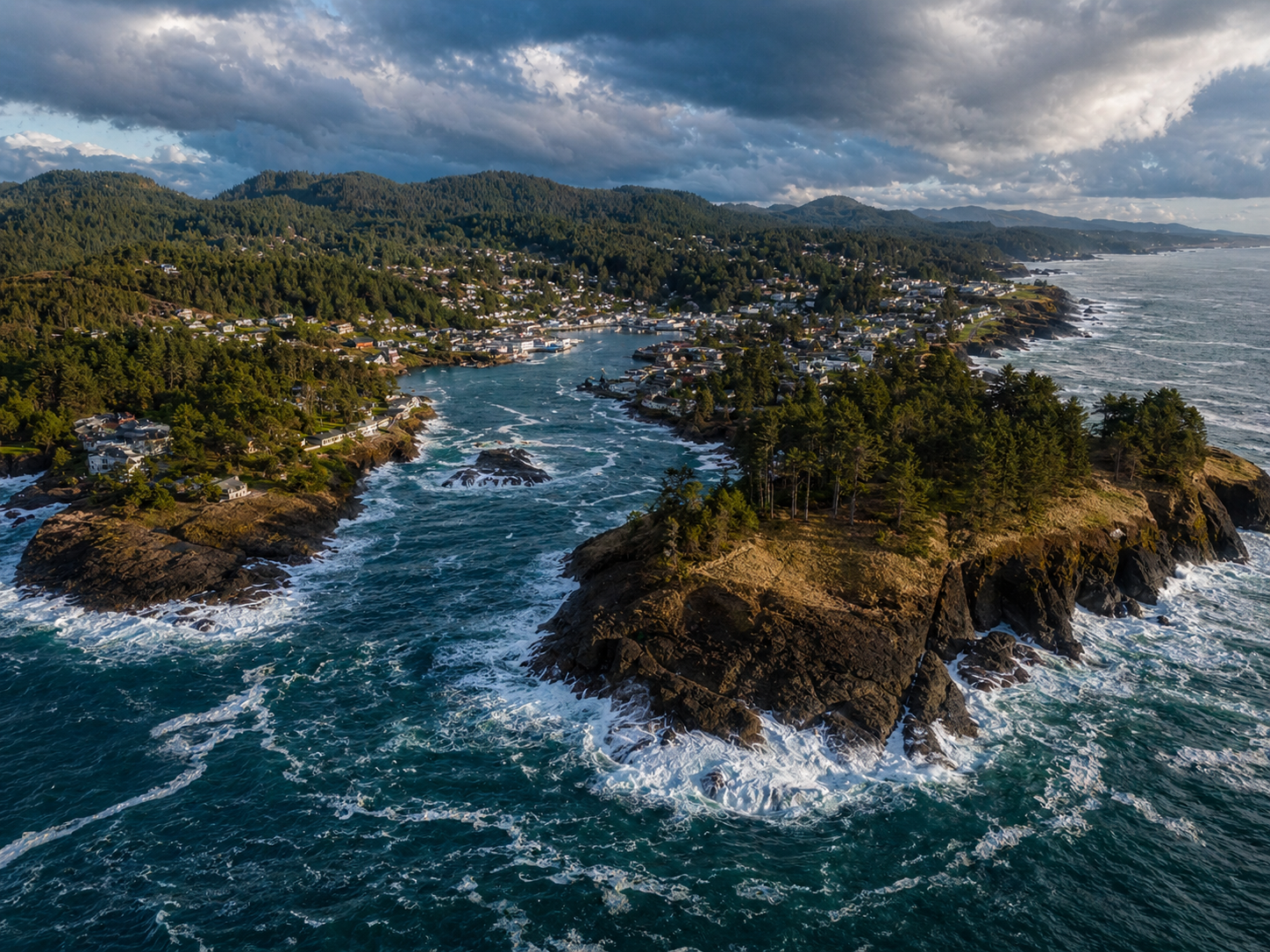
The coast is divided informally into three sections. The North Coast, from Astoria to Lincoln City, is dramatic and rocky, with prominent headlands (Tillamook Head, Cape Falcon, Cape Lookout) and the iconic sea stacks of Cannon Beach. The Central Coast, Lincoln City to Florence, has the heaviest concentration of state parks, lighthouses, and the only true sand dunes south of Florence. The South Coast, Florence to Brookings, is the wildest and most remote, with the famous Samuel H. Boardman State Scenic Corridor and the Wild Rivers Coast.
U.S. Highway 101 follows the coast for its entire length, often within sight of the water. Oregon has 80+ state parks and recreation sites along this stretch, more than any other coastal state per mile. Major coastal features include:
- Haystack Rock at Cannon Beach: a 235-foot basalt sea stack and one of the most photographed natural features on the West Coast.
- The Oregon Dunes National Recreation Area: 40 miles of coastal sand dunes between Florence and Coos Bay, the largest expanse of temperate coastal dunes in North America. Some dunes reach 500 feet above sea level.
- Cape Perpetua: at 800 feet, the highest viewpoint directly accessible by car on the Oregon Coast. Site of Thor’s Well, Devil’s Churn, and the Spouting Horn.
- Samuel H. Boardman State Scenic Corridor: 12 miles of cliff-top trail and viewpoints near Brookings, often considered the most scenic stretch of the entire coast.
- Heceta Head Lighthouse: built in 1894 on a 205-foot promontory, the strongest light on the Oregon Coast and one of the most photographed lighthouses in the U.S.
The Pacific climate at the coast is mild year-round (45 to 65°F most of the year) but very wet, with 60 to 100+ inches of rain annually. Summer fog is common, and storms in the winter regularly bring 50+ mph winds. Best hikes on the Oregon Coast →
Rivers and watersheds
Oregon’s rivers tell the story of the state’s geography in a single map. Almost everything west of the Cascades drains either north into the Columbia or directly to the Pacific. Almost everything east of the Cascades drains into the Snake or sinks into the Great Basin. Two watersheds, one mountain range.
| River | Length | Source | Mouth | Notable for |
|---|---|---|---|---|
| Columbia | 1,243 mi | British Columbia | Pacific (Astoria) | Largest river in PNW; OR/WA border |
| Snake | 1,078 mi | Wyoming | Columbia | OR/ID border; carves Hells Canyon |
| Willamette | 187 mi | Cascade Range | Columbia (Portland) | 13th-largest U.S. river by flow |
| John Day | 281 mi | Strawberry Mtns | Columbia | Longest free-flowing river entirely in OR |
| Deschutes | 252 mi | Little Lava Lake | Columbia | Spring-fed, world-class fishing |
| Rogue | 215 mi | Crater Lake area | Pacific (Gold Beach) | One of original 8 Wild & Scenic Rivers |
| Umpqua | 111 mi | Cascade Range | Pacific (Reedsport) | Famous summer steelhead |
The Columbia River
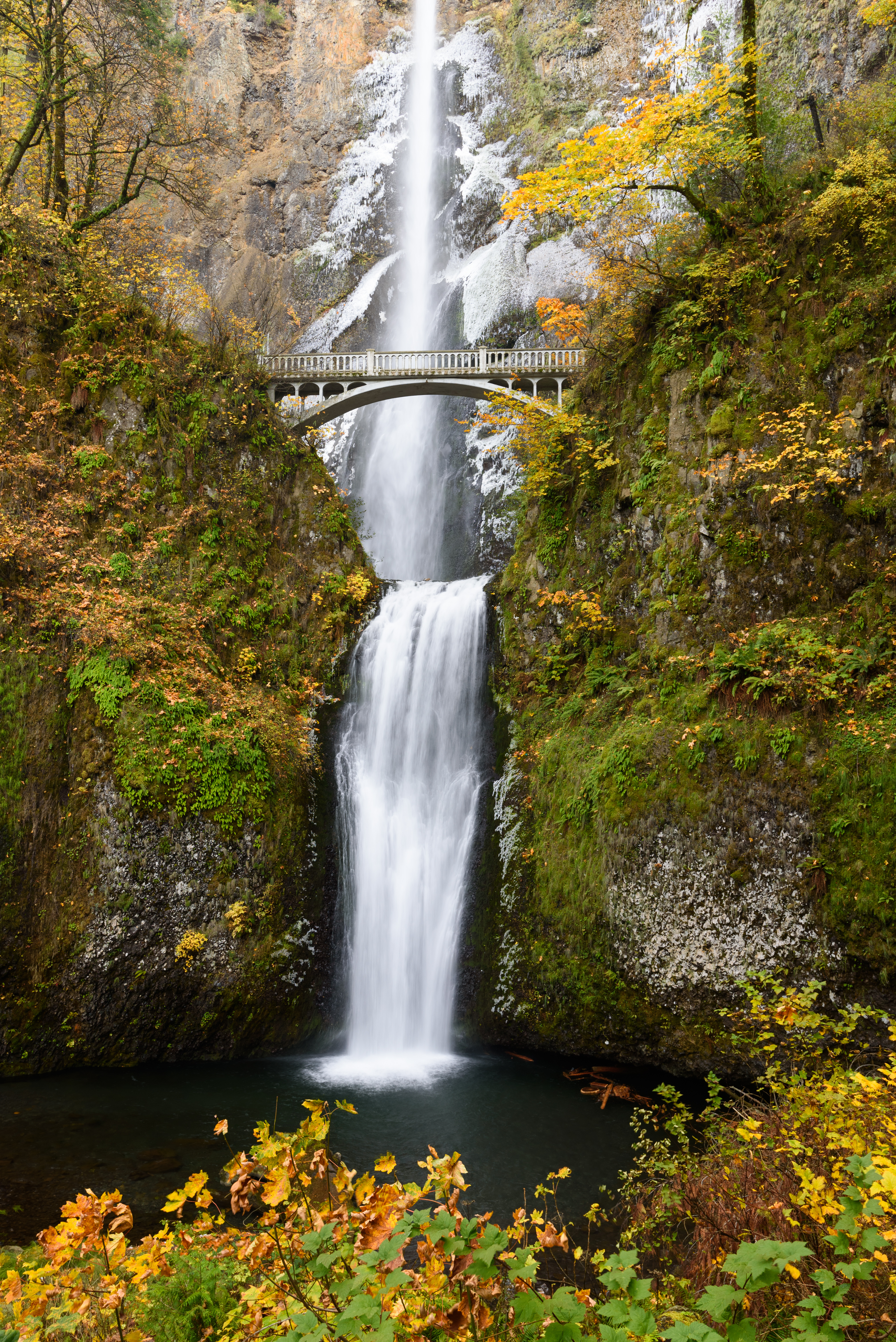
The Columbia is the largest river in the Pacific Northwest by volume and the 4th-largest in the U.S. It rises in British Columbia, flows about 1,243 miles total, and forms 309 miles of the Oregon-Washington border. The Columbia carved the Columbia River Gorge, an 80-mile river canyon between the Cascades that contains the highest concentration of waterfalls in North America (over 90 within a 20-mile stretch, including 620-foot Multnomah Falls). The Columbia is also the only river that cuts entirely through the Cascade Range, providing the lowest-elevation land route between the Pacific Northwest interior and the coast.
The Snake River and Hells Canyon
The Snake forms 216 miles of the Oregon-Idaho border, including Hells Canyon, the deepest river gorge in North America. The canyon reaches a depth of 7,993 feet from the rim of He Devil Peak to the river, deeper than the Grand Canyon. The Snake is part of the Columbia watershed and was a critical landmark on the Oregon Trail.
The Willamette and the valley
The Willamette is the river that built modern Oregon. It flows north 187 miles through the Willamette Valley, the agricultural heart of the state, and empties into the Columbia at Portland. About 70% of Oregon’s population lives within the Willamette watershed. The river’s flat-bottomed valley is the result of glacial Lake Missoula floods (the Bretz floods) at the end of the last ice age, which deposited rich sediment up to 30 feet deep across the valley floor. The Beaverton, Hillsboro, Salem, Albany, Corvallis, and Eugene metropolitan areas all sit on this sediment.
Eastside rivers
The Deschutes rises from springs in the high Cascades and runs north through Bend before joining the Columbia. It is one of the most famous trout and steelhead rivers in the country and has nearly constant year-round flow because most of its water comes from snowmelt-fed springs rather than direct runoff. The John Day is the longest free-flowing river entirely within Oregon (281 miles, no major dams) and runs through the painted rock formations of the John Day Fossil Beds. The Rogue rises near Crater Lake and runs west to the Pacific, and was one of the original eight rivers protected under the 1968 Wild and Scenic Rivers Act.
The Oregon high desert
About two-thirds of Oregon, everything east of the Cascade crest, is high desert and sagebrush steppe. This is the part of the state most visitors never see, and it’s where Oregon’s geography gets genuinely strange: dry lake beds, fault-block mountains, single-road counties, and night skies dark enough to see the Milky Way as a structured object.
The high desert sits at 4,000 to 5,000 feet of elevation. It looks like desert, but the elevation makes it cold in winter (it routinely drops below zero in January) and very hot in summer (95 to 105°F is typical in July). Annual precipitation is 8 to 14 inches, most of it falling as winter snow rather than rain. The dominant vegetation is big sagebrush, western juniper, and bunchgrass.
Key high desert features include:
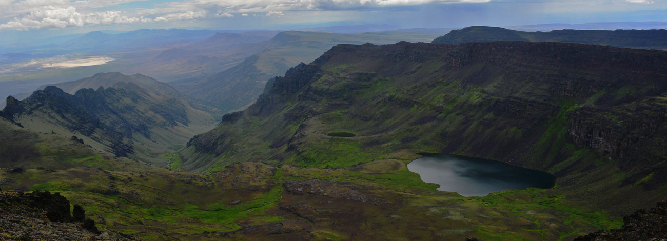
- Steens Mountain: a 50-mile-long fault-block ridge that tilts gently up from the west and drops 5,500 feet straight off the eastern face into the Alvord Desert. The summit at 9,733 feet is the highest point in the southeastern third of Oregon.
- The Alvord Desert: a dry alkali playa east of Steens Mountain, 12 miles long by 7 miles wide, hard-packed and flat enough that land-speed-record runs have been attempted there.
- Malheur National Wildlife Refuge: 187,000 acres of marshes and lakes that form a critical migration stopover on the Pacific Flyway. Birders see 320+ species over the course of a year.
- Hart Mountain National Antelope Refuge: 270,000 acres of high desert managed for pronghorn antelope and bighorn sheep. Has the only natural hot springs you can soak in within a national wildlife refuge.
- The Owyhee Canyonlands: 4.6 million acres of canyon country in southeastern Oregon, often called “Oregon’s Grand Canyon.” The Owyhee River has carved 1,000-foot canyons into rhyolite and basalt.
- Fort Rock: a 325-foot tuff ring in central Oregon, formed when a volcanic eruption met a Pleistocene-era lake. Some of the oldest sandals in the world (~10,000 years) were found in a nearby cave.
The high desert is part of the larger Great Basin, the only major U.S. region whose rivers don’t drain to an ocean. Rivers in the Great Basin flow into closed basins and either evaporate or sink into the ground. The Great Basin extends across most of Nevada, western Utah, and southeastern Oregon. Eastern Oregon hikes →
Climate & the rain shadow
Oregon is one of the few places where you can stand in two completely different climates within a single day’s drive. The Cascade Range creates one of the sharpest rain shadows in North America, and the difference shows up clearly in the numbers.
| City | Region | Annual rain | Avg high (Jul) | Avg low (Jan) |
|---|---|---|---|---|
| Astoria | North Coast | ~67 in | 69°F | 37°F |
| Portland | Willamette Valley | ~43 in | 82°F | 36°F |
| Eugene | South Willamette | ~46 in | 83°F | 34°F |
| Government Camp | Cascade crest | ~107 in | 69°F | 22°F |
| Bend | Central OR (E. side) | ~12 in | 83°F | 22°F |
| Burns | SE Oregon | ~10 in | 87°F | 17°F |
| Pendleton | NE Oregon | ~13 in | 89°F | 27°F |
The pattern is consistent: very wet on the coast and the western Cascades, mild and moderately wet in the Willamette Valley, drier and colder at high elevation, and dry and seasonally extreme on the east side. The wettest place in Oregon, Laurel Mountain in the Coast Range, averages over 200 inches of precipitation a year. The driest, in the Alvord Desert, averages under 7.
Oregon also gets meaningful summer wildfire activity, especially in the eastern and southern parts of the state. Fires typically peak in late July through September, and smoke can settle into the valleys for days at a time. The wildfire season has gotten longer and more intense over the past two decades. The state government posts daily updates at oregon.gov/odf/fire.
Volcanoes & geology
Almost every dramatic landform in Oregon is volcanic in origin. The state sits on the Cascade Volcanic Arc, part of the Pacific Ring of Fire, and has more than a dozen major volcanoes considered potentially active. The U.S. Geological Survey monitors all of them.
The biggest volcanoes in Oregon, north to south:
- Mt. Hood (11,249 ft): Oregon’s highest peak and most heavily monitored volcano. Last erupted around 1865. Active fumaroles near the summit. Skiing year-round at Timberline.
- Mt. Jefferson (10,497 ft): The most rugged Cascade volcano in Oregon. Heavily glaciated and considered active but dormant.
- Three Sisters (10,358 / 10,047 / 10,085 ft): Three closely spaced stratovolcanoes west of Bend. The South Sister has shown ground deformation since 2001, indicating subsurface magma movement.
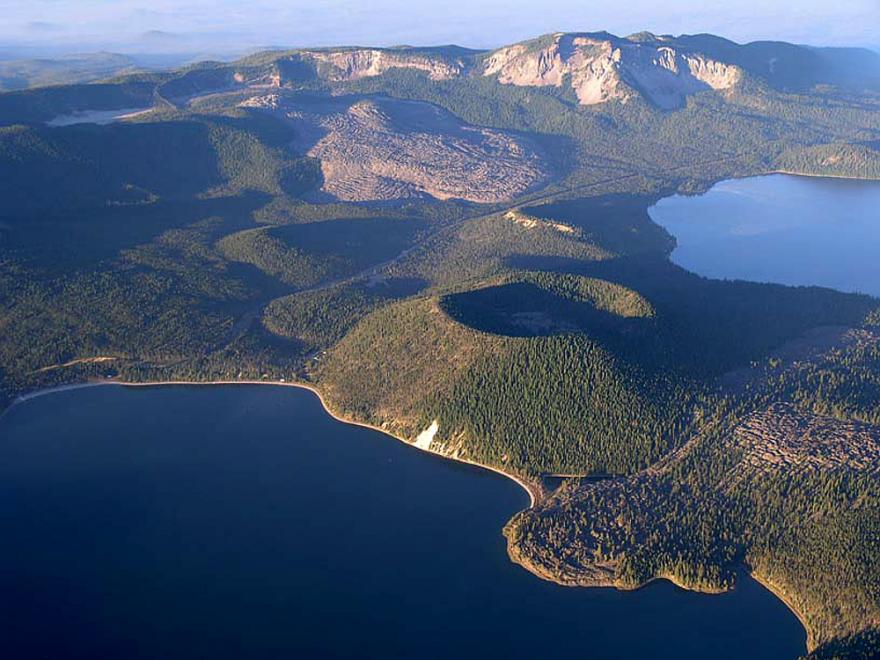
- Newberry Volcano (7,989 ft): A massive shield volcano with a 5-by-6-mile caldera containing East Lake and Paulina Lake. Last erupted about 1,300 years ago, the most recent eruption in Oregon.
- Mt. Bachelor (9,068 ft): A young stratovolcano that built up between 18,000 and 8,000 years ago. Now Oregon’s largest ski area.
- Crater Lake / Mt. Mazama (former 12,000 ft, now 1,949 ft deep caldera): Mazama collapsed catastrophically about 7,700 years ago, leaving the Crater Lake caldera. Witness accounts from Indigenous Klamath people preserve the eruption in oral tradition.
- Mt. Thielsen (9,184 ft): An eroded shield volcano known as the “Lightning Rod of the Cascades” because of how often its sharp summit attracts strikes.
- Mt. McLoughlin (9,495 ft): A symmetrical stratovolcano in southern Oregon, the dominant peak of the southern Cascades.
Beyond the stratovolcanoes, Oregon has extensive shield volcanoes, lava tubes, cinder cones, and basalt plateaus. The Columbia River Basalt Group, a series of massive flood-basalt eruptions between about 17 and 6 million years ago, covered roughly 81,000 square miles of the Pacific Northwest with lava up to 6,000 feet thick. Most of northeastern Oregon and the Columbia Plateau is built on these flows. The cliffs along the Columbia River Gorge are layers of these basalts, exposed by the river’s erosion.
Visible volcanic features you can hike include the Lava River Cave (a mile-long lava tube near Bend), Lava Butte (a 500-foot cinder cone with a paved road to the rim), the Big Obsidian Flow (Oregon’s youngest lava flow, 1,300 years old, in Newberry caldera), McKenzie Pass (a 75-square-mile lava field crossed by a scenic byway), and the Crooked River caldera at Smith Rock State Park (an ash-flow tuff carved by the Crooked River).
Lakes
Oregon has more than 1,400 named lakes, and most of them are products of either glaciation or volcanic activity. The largest by surface area is Upper Klamath Lake (96,000 acres) in southern Oregon. The deepest, by a long stretch, is Crater Lake.
Crater Lake
Oregon’s only national park and the deepest lake in the U.S. at 1,949 feet (the 9th-deepest in the world). The lake fills a 6-mile-wide caldera left after Mt. Mazama collapsed 7,700 years ago. Crater Lake has no rivers flowing in or out: the entire water budget is rain and snowmelt from inside the caldera, balanced by evaporation and seepage. The water is famously clear (visibility regularly exceeds 100 feet) and famously blue, the result of the depth and the lack of dissolved organic material. Things to do at Crater Lake →
Wallowa Lake
A classic moraine-dammed glacial lake at the foot of the Wallowa Mountains. Formed when retreating Pleistocene glaciers left behind a U-shaped valley dammed by terminal moraines. 5 miles long, 283 feet deep, and considered by many to be the most scenic lake in eastern Oregon. The Wallowa Lake Tramway climbs to 8,150 feet on Mt. Howard for views of the Eagle Cap Wilderness.
Waldo Lake
One of the purest lakes in the world. Waldo Lake sits high in the Cascades and has very little watershed feeding it, which means almost no dissolved organic matter or nutrients. Underwater visibility regularly exceeds 100 feet, comparable to Crater Lake. No motorized boats are allowed. The 6,300-acre lake is the second-largest natural lake entirely in Oregon.
Other significant Oregon lakes include Diamond Lake (between Mt. Bailey and Mt. Thielsen, popular for trout fishing), Detroit Lake (a Willamette tributary reservoir, popular for boating), Lake of the Woods in southern Oregon, the chain of Cascade Lakes along the Cascade Lakes Scenic Byway near Bend (Sparks Lake, Devils Lake, Elk Lake, Hosmer Lake, Cultus Lake), and Lake Owyhee, a long, narrow reservoir in the Owyhee Canyonlands. Full Oregon Lakes guide and map →
The 9 ecoregions of Oregon
The U.S. Environmental Protection Agency divides North America into nested ecoregions based on geology, soils, climate, vegetation, and wildlife. Oregon contains nine EPA Level III ecoregions, more than most states. Together they range from temperate rainforest to high-elevation alpine to true desert.
| Ecoregion | Where | Climate | Vegetation |
|---|---|---|---|
| Coast Range | Pacific to Willamette | Wet, mild | Doug fir, hemlock, spruce |
| Willamette Valley | I-5 corridor | Mild, moderate rain | Oak savanna, farmland |
| Cascades | N-S spine of state | Wet west, dry east, cold up | Doug fir, true firs, alpine |
| Klamath Mountains | SW corner | Mediterranean | 3,500+ plant species |
| Eastern Cascade Foothills | E. side of Cascades | Dry, sunny | Ponderosa pine, juniper |
| Columbia Plateau | NE Oregon plains | Semi-arid | Bunchgrass, dryland wheat |
| Blue Mountains | NE interior | Cool, snowy winters | Ponderosa, fir, lodgepole |
| Snake River Plain | Far E along Snake | Hot dry summers | Sagebrush, irrigated ag |
| Northern Basin & Range | SE corner | Cold desert | Sagebrush steppe, salt flats |
The 9-ecoregion split is the cleanest way to understand Oregon’s biological geography. The Coast Range and the western Cascades are temperate rainforest, with some of the highest biomass per acre of any forest type on Earth. The Willamette Valley is rich farmland that originally was oak savanna and prairie, now mostly converted. The Klamath Mountains in the southwest are a global biodiversity hotspot, home to plant species found nowhere else. The eastern ecoregions transition through ponderosa pine forest into sagebrush steppe and finally into the cold-desert Basin and Range.
The human geography of Oregon
The physical map of Oregon and the human map don’t line up the way most states’ do. Oregon is the 9th-largest state by area but only the 27th by population, which makes the population unusually concentrated. About 70% of Oregonians live in the Willamette Valley along the I-5 corridor, on roughly 8% of the state’s land. The remaining 92% of the state is home to the other 30%.
The reason, again, is the Cascade Range. The valley west of the Cascades is mild, fertile, and easy to settle. The desert east of them is dry, cold in winter, and hard to make a living on without irrigation or large grazing leases. Almost every population pattern in Oregon traces back to that single geographic fact.
Where Oregonians actually live
Portland metro accounts for roughly 2.5 million people, the largest urban area in the Pacific Northwest after Seattle. The next biggest population centers are Salem (the capital), Eugene, Gresham, Hillsboro, Beaverton, and Bend. All but Bend sit in the Willamette Valley. Bend is the only large city east of the Cascades and has been one of the fastest-growing cities in the U.S. for two decades, fueled by recreation and remote work.
Out in the high desert, the population density flips upside down. Harney County in the southeast covers 10,228 square miles (larger than Massachusetts, Connecticut, and Rhode Island combined) and is home to fewer than 8,000 people. That works out to about 0.7 people per square mile, one of the lowest densities in the lower 48.
About half of Oregon is publicly owned
Roughly 52% of Oregon’s land area is in public ownership, one of the highest percentages of any U.S. state. The Bureau of Land Management manages about 16 million acres, mostly the high-desert rangeland of eastern and southeastern Oregon. The U.S. Forest Service manages about 15 million acres across 12 national forests, mostly the wet western and Cascade slopes. Oregon also has one national park (Crater Lake), the John Day Fossil Beds National Monument, multiple national wildlife refuges, and 360+ state parks. The 1967 Beach Bill made all 363 miles of ocean coastline public, the only state where this is the case.
The practical implication: an enormous share of the state is hikeable, campable, or otherwise accessible. The trail-density map of Oregon and the public-land map are functionally the same map.
The nine tribal nations of Oregon
Oregon was densely populated for thousands of years before European contact, particularly along the Columbia River and the lower Willamette, where seasonal salmon runs supported some of the highest pre-Columbian population densities anywhere in North America. Today there are nine federally recognized tribes in Oregon: the Confederated Tribes of the Umatilla Indian Reservation, the Confederated Tribes of Warm Springs, the Confederated Tribes of Grand Ronde, the Confederated Tribes of Siletz Indians, the Confederated Tribes of Coos, Lower Umpqua and Siuslaw Indians, the Coquille Indian Tribe, the Cow Creek Band of Umpqua Tribe, the Klamath Tribes, and the Burns Paiute Tribe. Each maintains a reservation or trust lands within the state.
The east-west divide also shows up clearly on the economic map. West of the Cascades is a timber, agriculture, technology, and education economy: Intel and Nike in the Portland metro, the wine industry across the Willamette Valley, Oregon State University in Corvallis, the University of Oregon in Eugene. East of the Cascades is ranching, dryland wheat, hay, timber, and increasingly recreation tourism, especially around Bend, the Wallowas, and the southern Cascades. Oregon’s voting maps, school enrollment maps, and broadband-coverage maps all trace the same Cascade boundary the climate map does. See our seven travel regions of Oregon →
Oregon’s geographic records
A handful of Oregon places are best-in-class on a regional, national, or even global scale.
- Deepest lake in the United States: Crater Lake at 1,949 feet. 9th deepest in the world.
- Deepest river gorge in North America: Hells Canyon on the Snake River, 7,993 feet from rim to river. Deeper than the Grand Canyon.
- Most diverse temperate coniferous forest in the world: the Klamath Mountains, with over 30 native conifer species and 3,500+ native plants.
- Largest coastal sand dunes in North America: the Oregon Dunes, 40 miles long, with peaks up to 500 feet.
- Highest concentration of waterfalls on the continent: the Columbia River Gorge has 90+ named waterfalls within a 20-mile stretch.
- Tallest waterfall in Oregon: Multnomah Falls at 620 feet, the second-tallest year-round waterfall in the U.S.
- Smallest navigable harbor in the world: Depoe Bay, six acres, often called the “whale watching capital of the Oregon Coast.”
- Only entirely-public ocean coastline in the U.S.: all 363 miles, from Astoria to Brookings, since the 1967 Beach Bill.
- Oldest extant sandals: ~10,000 years old, found in Fort Rock Cave in central Oregon’s high desert.
- Largest fossil bed of its kind in the world: the John Day Fossil Beds, 50+ million years of paleontological record in three units.
- Longest free-flowing river in OR: the John Day, 281 miles, no major dams.
- Lowest population density in the lower 48 (by county): Harney County, with about 0.7 people per square mile.
The Seven Wonders of Oregon
In 2014, Travel Oregon named seven natural landmarks as the state’s most iconic destinations. The list is unofficial but widely accepted, and it doubles as a good shortlist of Oregon’s geographic highlights. All seven sit at the intersection of dramatic landscape and reasonable accessibility.
Frequently asked questions
What are the main geographic regions of Oregon?
How big is Oregon?
What is the highest point in Oregon?
Why is Eastern Oregon so different from Western Oregon?
How long is the Oregon Coast?
What states border Oregon?
What is the deepest lake in Oregon?
Are there volcanoes in Oregon?
What is the longest river in Oregon?
What is Oregon’s climate like?
How many ecoregions does Oregon have?
Where do most Oregonians live?
What percentage of Oregon is publicly owned?
How many Native American tribes are in Oregon?
Last updated: May 2026 · Oregon’s geography is stable; population, fire, and climate data update more frequently. Verify the latest at the State of Oregon and the U.S. Geological Survey as needed.