
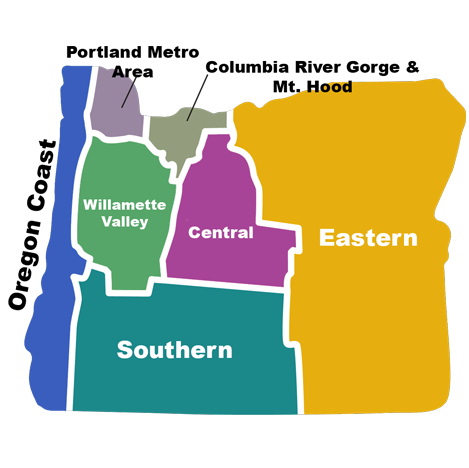
The 7 Regions of Oregon
Oregon is one of the most geographically varied states in the country. In about 350 miles you go from Pacific rainforest to high-desert canyon, separated by the Cascade Range. This guide covers the seven distinct regions: how they differ, what each is known for, and how to choose the right one for your trip.
Oregon at a glance
Oregon is the 9th-largest state by area but contains a dramatic range of climate, terrain, and ecology in a relatively small footprint. Per Travel Oregon’s official tourism framework, the state is divided across seven geographically distinct regions: the Portland Region, the Oregon Coast, the Willamette Valley, Mt. Hood & The Columbia River Gorge, Central Oregon, Southern Oregon, and Eastern Oregon. Each has its own climate, its own iconic landscapes, its own pace, and its own personality.
The reason for so much variation in such a small space is one geographic feature: the Cascade Range. Running north-south through the state, the Cascades create a dramatic rain-shadow effect: moisture-heavy storms from the Pacific dump 60-100+ inches of precipitation on the west side, then cross the mountains and arrive on the east side already wrung out. The result is that western Oregon is temperate rainforest and eastern Oregon is high desert, despite the two being only about 100 miles apart in places.
This guide breaks down each region in detail, explains what makes each one distinct, and provides a decision framework for choosing where to focus your trip. If you’re planning a first visit to Oregon, the “How to choose a region” section near the bottom of this page is the fastest way to figure out where to go based on what you want to do.
Why Oregon’s geography is so varied
Oregon packs a remarkable amount of climate and ecological diversity into a relatively small footprint. The reason is the Cascade Range, a chain of volcanic peaks that runs the length of the state north to south. The Cascades create one of the most dramatic rain-shadow effects on the continent (covered in detail by the Oregon Encyclopedia). (For a deeper dive into Oregon’s mountain ranges, river systems, and ecological zones, see our companion guide to Oregon’s geography.)
Pacific storms move east, hit the Cascades, and dump most of their moisture on the west side. Rainforest grows on the western slopes of the Cascades and along the coast (some areas average more than 100 inches of precipitation per year). Once the storms cross the Cascades, the air is dry. Eastern Oregon receives only 8 to 16 inches of precipitation in most places, and some Eastern Oregon basins are technically high desert.
The result: from the Oregon Coast to the high desert in the east, the state has nine recognized climate zones, the largest range of any state in the contiguous United States after California. Each of Oregon’s seven regions sits in a different climate niche.
- The Cascades are the biggest dividing line. West of the crest is wet and forested. East of the crest is dry and open.
- The Coast Range creates a smaller secondary rain shadow. The Willamette Valley sits in the gap between the Coast Range and the Cascades.
- The Wallowa, Blue, and Klamath ranges create their own local micro-climates with isolated alpine zones in otherwise dry country.
- The Pacific Ocean moderates the climate of the western third of the state. Coastal temperatures rarely exceed 75°F or drop below 35°F, even in the most extreme months.
Driving across Oregon east-to-west on Highway 26 (Portland to Ontario, about 380 miles) crosses the Coast Range, the Willamette Valley, the Cascades, the Central Oregon high desert, the Blue Mountains, and the dry plateaus along the Snake River. It is one of the most dramatic single-day drives in the United States for the sheer variety of landscape.
The 7 regions of Oregon
Oregon’s seven regions are each defined by a combination of geography and climate. The regions overlap at the edges (where exactly does the Willamette Valley end and the Cascades begin?), but the major boundaries are clear and consistent across travel guides, climate maps, and ecological surveys. Here is the framework we use throughout this guide:
1. Portland Region

Must-see in this region:
- Powell’s City of Books
- Forest Park (5,200 acres)
- Portland Japanese Garden
- Pittock Mansion (Mt. Hood views)
- The food cart pods + Voodoo Doughnut
Oregon’s largest metro and cultural capital. The Portland Region sits at the confluence of the Willamette and Columbia rivers in the far northwest corner of the state, and it’s where about 2.5 million Oregonians live, more than half the state’s population. Portland itself is the centerpiece, with Beaverton, Hillsboro, Lake Oswego, Tigard, and Gresham all part of the broader metro.
Major cities: Portland, Beaverton, Hillsboro, Gresham, Lake Oswego, Tigard, Oregon City.
Geography & climate: The region sits in the northern Willamette Valley with the Cascade Range to the east (Mt. Hood is visible on clear days from much of the metro) and the Coast Range to the west. Temperatures are mild year-round, summer highs around 80°F, winter lows in the upper 30s, with the famous gray drizzle from October through May. About 36 inches of annual rainfall, though most days are simply overcast rather than actively raining.
What it’s known for: Food carts, third-wave coffee, craft beer (more breweries than any city in the world per capita), the largest independent bookstore in the world (Powell’s), Forest Park (the largest urban forest in the U.S.), the Portland Japanese Garden, Voodoo Doughnut, the Saturday Market, the rose gardens at Washington Park, and a famously eccentric culture summarized by the unofficial motto “Keep Portland Weird.”
Iconic spots: Pittock Mansion (Mt. Hood views), the Portland Japanese Garden (rated the most authentic outside Japan), Powell’s City of Books, the International Rose Test Garden, the Tom McCall Waterfront Park, the Oregon Zoo, and the bridges across the Willamette (12 of them, each with its own personality).
Best months: Late June through early October. Summers are dry and warm. Spring (March-May) is rainy but offers cherry blossoms and rhododendrons. Winter is gray and damp; ski trips to Mt. Hood are an easy day trip from the city.
Day trips from Portland: Multnomah Falls and the Columbia River Gorge (45 min east), Cannon Beach (90 min west), Mt. Hood (75 min east), Willamette Valley wine country (45 min south), and Hood River (60 min east). Portland is the most common Oregon trip launching point because of Portland International Airport and its central position.
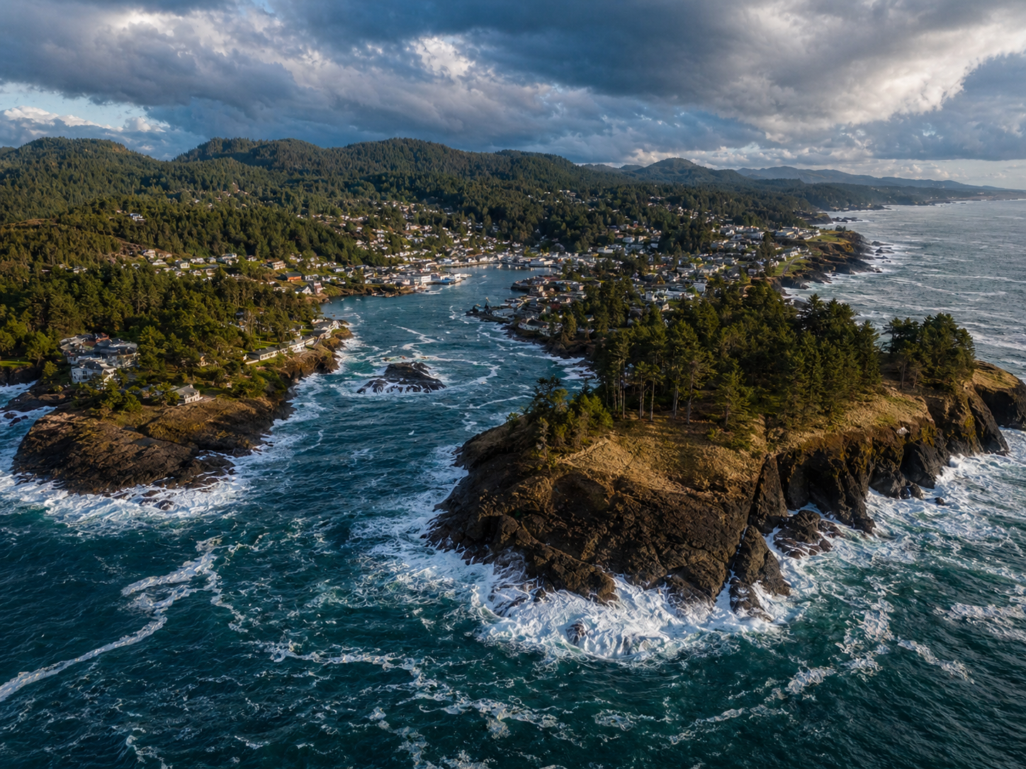
2. Oregon Coast
Must-see in this region:
- Haystack Rock at Cannon Beach
- Samuel H. Boardman Scenic Corridor
- Cape Perpetua & Thor’s Well
- The Oregon Dunes
- Yaquina Head Lighthouse
363 miles of fully-public coastline. By state law (the 1967 Oregon Beach Bill), every inch of the Oregon Coast is open to the public, all the way down to the high tide line. There are no private beaches, no resort-only stretches, no gated access points. This is one of the things that makes the Oregon Coast unique in the United States.
Major cities: Astoria (north), Cannon Beach, Tillamook, Lincoln City, Newport, Florence, Coos Bay, Bandon, Brookings (south).
Geography & climate: A narrow strip running 363 miles along the Pacific, backed by the Coast Range. Temperatures are remarkably stable: summer highs rarely exceed 70°F and winter lows rarely drop below 38°F. Rain is the defining feature: 60 to 100+ inches annually, with most falling October through April. Summer is dry, foggy in the morning, sunny by afternoon.
What it’s known for: Sea stacks (Haystack Rock, Cape Kiwanda, Pacific City), tide pools (Cape Perpetua, Yaquina Head), lighthouses (Heceta Head, Yaquina Head, Cape Blanco), surfing (Pacific City, Cape Kiwanda), the Samuel H. Boardman corridor with its sea-stack panoramas (Natural Bridges, Secret Beach), the Oregon Dunes National Recreation Area (40 miles of sand dunes), and Tillamook cheese. The southern coast (Brookings to Coos Bay) is the warmest and least crowded; the northern coast (Astoria to Lincoln City) is closest to Portland and busiest.
Best time to visit: July through September is the dry-warm-and-sunny season but also the most crowded. May, June, and October offer milder crowds with mostly-dry weather. Storm-watching season runs November through February (huge waves, dramatic skies, mostly-empty beaches). Avoid winter only if you specifically need warm weather.
Plan a coast trip: See our roundups of the best Oregon Coast hikes, the Oregon Dunes National Recreation Area, and our things to do in Astoria guide for the northern coast hub.
3. Willamette Valley

Must-see in this region:
- Silver Falls State Park (Trail of Ten Falls)
- Willamette Valley wineries
- Eugene & the University of Oregon
- McMinnville for wine tasting
- The Oregon Garden in Silverton
Oregon’s most populated region by far. Roughly 70 percent of Oregonians live in the Willamette Valley, including everyone in Portland (city pop. ~635,000; metro 2.5 million), Salem (~175,000), and Eugene (~175,000), plus the smaller hubs of Corvallis, Albany, Hillsboro, Beaverton, and McMinnville. The Willamette Valley is essentially the spine of Oregon’s economy, agriculture, and population.
Major cities: Portland, Salem (state capital), Eugene, Corvallis, Albany, Hillsboro, McMinnville.
Geography & climate: A 150-mile-long valley running north-south between the Coast Range (west) and the Cascades (east), drained by the Willamette River. Mild wet winters (35-45 inches of rain annually) and warm dry summers. Portland summer highs average 80-85°F; winter lows 35-40°F. Snow is rare in Portland (a few inches per year) but more common in the southern valley around Eugene.
What it’s known for: Pinot Noir wine country (Oregon is the third-largest wine-producing state, with most production in the Willamette Valley AVA), Multnomah Falls and the Columbia River Gorge waterfalls (technically on the boundary with the Cascades but accessed from Portland), Portland’s food and coffee scene, Powell’s City of Books, Voodoo Doughnut, Forest Park (5,200 acres of urban forest in Portland), the State Capitol in Salem, the University of Oregon in Eugene, and the western terminus of the historic Oregon Trail at Oregon City.
Best time to visit: June through September for the warmest dry weather. April and May for spring wildflowers and waterfall flow. October for fall colors in the valley vineyards. Avoid November through March if you don’t tolerate gray rainy weather.
Plan a Willamette Valley trip: Browse our Oregon wineries list, our Willamette Valley hikes, and our Trail of Ten Falls at Silver Falls State Park guide.
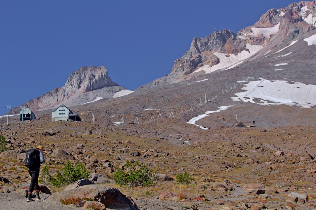
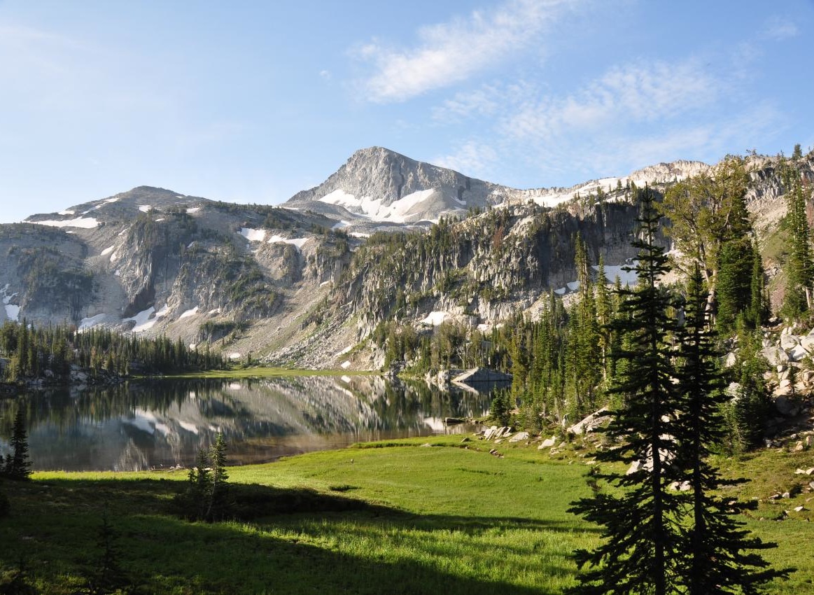
4. Mt. Hood & The Columbia River Gorge
Must-see in this region:
- Multnomah Falls
- Timberline Lodge on Mt. Hood
- Vista House at Crown Point
- Hood River for kiteboarding & orchards
- The Historic Columbia River Highway
The volcanic spine of Oregon. The Cascade Range runs the length of the state, north to south, from the Columbia River to the California border. It includes Oregon’s tallest mountain (Mt. Hood at 11,239 feet), the deepest lake in the United States (Crater Lake at 1,949 feet, technically in Southern Oregon but part of the southern Cascades), and the highest concentration of waterfalls in North America (the Columbia River Gorge).
Major cities & areas: Hood River, Government Camp, Sisters, Bend (technically east of the Cascades but the gateway), Detroit, Oakridge.
Geography & climate: A volcanic mountain chain with peaks ranging from 5,000 to 11,239 feet. The climate varies dramatically with elevation and which side of the crest you’re on. The west slopes (closer to Portland and the valley) get heavy snow (300-500+ inches annually at the highest elevations) and rain at lower elevations. The east slopes are drier. Mt. Hood Meadows averages 430 inches of snow per season; Mt. Hood National Forest manages over 1.1 million acres surrounding the peak, and Timberline Lodge has the only year-round skiing in North America.
What it’s known for: Mt. Hood (year-round skiing at Timberline; Mirror Lake hike; Trillium Lake; Mt. Hood Loop drive), the Columbia River Gorge (Multnomah Falls, Latourell Falls, Eagle Creek, Vista House at Crown Point, Hood River windsurfing), the Cascade volcanoes (Mt. Jefferson, Three Sisters, Three Fingered Jack, Mt. Washington, Mt. Bachelor), the Pacific Crest Trail (which runs the length of the Cascades), Sisters’ McKenzie Pass scenic byway, and Detroit Lake.
Best time to visit: July through September for hiking (the high country is snowed in until late June most years). December through March for skiing. May and October are shoulder seasons; trails open progressively as snow melts.
Plan a Cascades trip: See our Columbia River Gorge hikes, our Mirror Lake Trail at Mt. Hood, and our best Oregon waterfall hikes guide.
5. Central Oregon

Must-see in this region:
- Smith Rock State Park
- The Three Sisters Wilderness
- Cascade Lakes Scenic Byway
- Mt. Bachelor (skiing + summer chairlift)
- Tumalo Falls
Bend is the hub. Central Oregon is the high-desert plateau immediately east of the Cascades, anchored by Bend (population ~106,000, but it feels bigger due to tourism). Central Oregon gets about 300 days of sun annually, has low humidity, and offers a completely different climate from the wet western half of the state. It is the fastest-growing region of Oregon and a popular destination for outdoor recreation in all four seasons.
Major cities: Bend, Redmond, Sisters, Madras, Prineville, La Pine, Sunriver, Terrebonne.
Geography & climate: High desert plateau at 3,000 to 4,000 feet of elevation, sitting in the rain shadow of the Cascades. Bend gets only 12 inches of precipitation annually (compare to Portland’s 36″). Summer highs average 85°F, winter lows 18°F. Snow is moderate but not heavy (about 30 inches annually in Bend; resort areas at higher elevations get hundreds). Four distinct seasons.
What it’s known for: Bend (craft breweries, the Deschutes River, the Old Mill District, mountain biking on Phil’s Trail), Smith Rock State Park (the birthplace of modern American sport climbing; one of the 7 Wonders of Oregon), the Cascade Lakes Highway (a scenic drive through alpine lakes including Sparks, Devil’s, Cultus, and Elk Lake), Mt. Bachelor ski resort, Sunriver (resort destination), Sisters (small western-themed town with the Sisters Rodeo), the High Desert Museum, and Newberry National Volcanic Monument (Lava Lands, lava tubes, Paulina Lake).
Best time to visit: Almost any season. June through September is peak. May and October are quieter and still mostly-dry. December through February for skiing. The advantage of Central Oregon’s climate is that there’s no truly bad season.
Plan a Central Oregon trip: See our Central Oregon hikes, our Smith Rock State Park guide, and our things to do in Bend roundup.
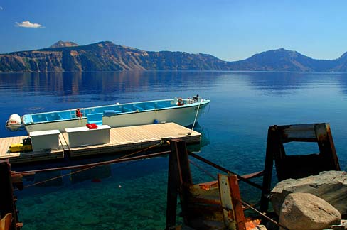
6. Southern Oregon
Must-see in this region:
- Crater Lake National Park
- Oregon Shakespeare Festival in Ashland
- The Rogue River (rafting + jet boats)
- Oregon Caves National Monument
- Mt. Thielsen + Diamond Lake
The state’s southern third. Southern Oregon stretches from the Cascades to the California border and includes Crater Lake National Park (Oregon’s only national park), the Rogue River, the Oregon Caves National Monument, and Ashland’s Oregon Shakespeare Festival. The climate is warmer and drier than the rest of western Oregon thanks to a more southerly latitude and the rain-shadowing effect of multiple ranges.
Major cities: Medford, Ashland, Grants Pass, Klamath Falls, Roseburg, Brookings (technically coast), Cave Junction.
Geography & climate: A mix of valleys, mountains, and high country. The Rogue Valley (Medford, Ashland) and Umpqua Valley (Roseburg) are warm and dry; Medford summer highs average 88°F and winter lows 32°F. The Cascades rise to the east (Crater Lake at 6,178 ft elevation, with snow on the rim from October through July). The Klamath Mountains in the southwest are unique geologically and ecologically (some of the most biodiverse forests in North America).
What it’s known for: Crater Lake National Park (deepest lake in the U.S., one of the 7 Wonders of Oregon, formed by the collapse of Mount Mazama 7,700 years ago), the Rogue River (white-water rafting, fishing, the Rogue River Trail), Oregon Shakespeare Festival in Ashland (running since 1935), the Oregon Caves National Monument, Crater Lake’s rim drive, Lithia Park in Ashland, the Umpqua Valley wine region (Pinot Noir and Tempranillo), the Britt Music Festival in Jacksonville, and Hellgate Canyon on the Rogue.
Best time to visit: July through September is peak (Crater Lake’s rim road is fully open, Shakespeare Festival is in full swing). May and June for waterfalls and lower crowds. October for fall colors in the Rogue Valley. Crater Lake’s south entrance road is open year-round, but the rim drive is closed by snow from late October through June most years.
Plan a Southern Oregon trip: Browse our Southern Oregon hikes, our Crater Lake National Park guide, and our Rogue-Umpqua Scenic Byway guide.
7. Eastern Oregon
Must-see in this region:
- The Painted Hills
- The Wallowa Mountains (Eagle Cap Wilderness)
- Hells Canyon (deeper than the Grand Canyon)
- Steens Mountain & the Alvord Desert
- John Day Fossil Beds (all 3 units)
The largest region by area, the smallest by population. Eastern Oregon covers about 56,000 square miles, more than 57 percent of the state’s total area, but contains only about 350,000 people: roughly 8 percent of the state population. It is the most remote, the driest, and the darkest region of Oregon, with almost no light pollution and some of the most dramatic geology in the United States.
Major cities: Pendleton, La Grande, Baker City, Ontario, Burns, John Day, Enterprise, Joseph (Wallowas), Mitchell, Dayville.
Geography & climate: High desert plateau (3,000-5,000 ft) intersected by mountain ranges (the Wallowas in the northeast, the Blue Mountains across the central section, Steens Mountain in the south). Precipitation is 8 to 16 inches annually in most places (though the Wallowas and Blues see much more). Summer highs are 85-100°F; winter lows are -10 to 25°F. Bigger temperature swings than any other Oregon region. Real snow in winter.
What it’s known for: The Painted Hills (one of the 7 Wonders of Oregon; part of John Day Fossil Beds National Monument), the Wallowa Mountains (the “Alps of Oregon”; granite peaks and alpine lakes; one of the 7 Wonders), Hells Canyon (the deepest river gorge in North America at 7,993 feet, on the Snake River along the Oregon-Idaho border), Steens Mountain (a 50-mile-long fault-block mountain rising to 9,738 feet over the Alvord Desert), the Alvord Desert (a flat dry lakebed used for land-speed records), Hart Mountain National Antelope Refuge, the Owyhee Canyonlands, ghost towns from the late-1800s gold rush (Granite, Sumpter), and dark-sky areas (most of Eastern Oregon qualifies as Bortle Class 1 or 2).
Best time to visit: May, June, September, and October. April for spring wildflowers in the Painted Hills. Summer is hot but works at higher elevations (the Wallowas, Steens). Avoid July and August at low elevations (110°F+ days are common).
Plan an Eastern Oregon trip: See our Eastern Oregon hikes, our Painted Hills guide, and our 3-day John Day Fossil Beds trip.
Climate comparison by region
Annual precipitation, summer high, winter low, sunshine, and best months for visiting, for all 7 regions of Oregon at a glance:
| Region | Annual rain | Summer high | Winter low | Climate | Best months |
|---|---|---|---|---|---|
| Portland Region | ~36 in | ~82°F | ~36°F | Marine, mild, gray winters | Jun-Oct |
| Oregon Coast | 60-100+ in | ~70°F | ~38°F | Marine, foggy, very moderate | Jul-Sep |
| Willamette Valley | 35-45 in | ~83°F | ~35°F | Mild wet winters, dry summers | May-Oct |
| Mt. Hood & The Gorge | 60-100+ in | ~75°F | ~25°F | Heavy snow, alpine, wet | Jun-Sep (ski Dec-Mar) |
| Central Oregon | 10-15 in | ~85°F | ~18°F | High desert, sunny, big swings | Jun-Oct |
| Southern Oregon | 15-25 in | ~88°F | ~32°F | Mediterranean-like, dry | Jun-Oct |
| Eastern Oregon | 8-16 in | ~92°F | ~15°F | High desert, biggest temp swings | May-Jun, Sep-Oct |
Two patterns to notice: the western regions (Coast, Portland, Willamette Valley, west Cascades) all get more than 35 inches of annual rain, while the eastern regions (Central, Southern, Eastern) get less than 25 inches in most places. And the temperature swing increases dramatically as you move east: the Coast has a 32°F annual range while Eastern Oregon has a 77°F range.
How to choose your region
If you’re planning a trip and trying to figure out where to focus, the fastest way is to identify what kind of trip you actually want. (For an official tourism overview by region, Travel Oregon’s region pages are useful too.) Here is the matchmaking framework we use most often:
| If you want… | Best region | Anchor town |
|---|---|---|
| Beaches & sea stacks | Oregon Coast | Cannon Beach or Newport |
| Wineries & Portland food scene | Willamette Valley | Portland or McMinnville |
| Waterfalls | Cascades / Columbia Gorge | Hood River |
| Skiing or snowboarding | The Cascades | Government Camp or Bend |
| Sunshine year-round | Central Oregon | Bend |
| Rock climbing | Central Oregon | Terrebonne (Smith Rock) |
| National parks | Southern Oregon | Klamath Falls or Medford |
| Theater & arts | Southern Oregon | Ashland |
| Solitude & wilderness | Eastern Oregon | Joseph or Frenchglen |
| Dark-sky stargazing | Eastern Oregon | Mitchell or Frenchglen |
| Geology & fossils | Eastern Oregon | Mitchell or Dayville |
| First-time Oregon visit | Willamette Valley + Coast + Cascades | Portland (5-7 day road trip) |
For first-time visitors, the Portland-Coast-Mt. Hood loop is the highest-density combination of Oregon’s most photographed attractions. From Portland you can do day trips to Cannon Beach (1.5 hours), Multnomah Falls (40 min), and Mt. Hood (1 hour), with overnights for Crater Lake (4 hours) or the Painted Hills (4 hours) requiring a separate trip. For repeat visitors, Eastern Oregon is the most underrated region, with the most dramatic geology and the lowest crowds. Central Oregon is the easiest year-round destination because of its consistently good weather.
More from the Oregon Guide
This Regions of Oregon page is one chapter in our complete guide to Oregon. Other chapters cover:
Frequently asked questions
How many regions does Oregon have?
What is the most populated region of Oregon?
What is the largest region of Oregon by area?
Which region of Oregon gets the most rain?
Which Oregon region has the best weather?
What region is Mt. Hood in?
What region is Crater Lake in?
What region are the Painted Hills in?
Why is Oregon’s geography so varied?
What is the best Oregon region for first-time visitors?
Which Oregon region is best for outdoor recreation?
Is Portland a separate region from the Willamette Valley?
Which Oregon region has the darkest skies for stargazing?
What is the smallest Oregon region by area?
Last updated: May 2026 · Climate stats are pulled from Oregon Climate Service data and the National Weather Service. City populations are 2023 U.S. Census estimates. Region boundaries follow the official seven-region tourism framework used by Travel Oregon, the Oregon Encyclopedia, and most state tourism resources.